San Bernardino Optimal Basin Management
Study Area
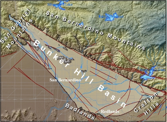
The San Bernardino area is a semiarid inland valley of about 120 square miles in southwestern San Bernardino County, about 60 miles east of Los Angeles, in the upper part of the Santa Ana River drainage basin. The San Bernardino area was defined by Dutcher and Garrett (1963) as a northwest-trending area between the San Andreas and San Jacinto faults. The area is bordered on the northwest by the San Gabriel Mountains, on the northeast by the San Bernardino Mountains, on the south by the badlands and Crafton Hills, and on the southwest by a low, east-facing escarpment of the San Jacinto fault. Alluvial fans extend from the base of the mountains and hills that surround the valley and coalesce to form a broad, sloping alluvial plain in the central part of the valley. Altitude ranges from about 1,000 feet (ft) near the city of San Bernardino to more than 10,000 ft in the San Bernardino Mountains.
San Bernardino Optimal Basin Management
Welcome to the U.S. Geological Survey (USGS) San Bernardino Optimal Basin Management website. This site provides hydrologic data collected or compiled by the USGS in the San Bernardino area; some additional data may be available from the USGS database National Water Information System (NWIS).
Project Chief: Wes Danskin
Phone: 619-225-6132
Email: wdanskin@usgs.gov
Questions about Optimal Basin Management? Please contact Wes Danskin (email: wdanskin@usgs.gov or send a letter). 619.225.6132