San Bernardino Optimal Basin Management
Overview
Problem
Historically, water purveyors have applied various techniques to solve water-supply and water-quality problems. Although most purveyors rely on some form of conjunctive use of surface and ground water, seldom is there optimal management of an entire water system. Improved management of complex hydrologic systems should be possible by developing and applying mathematical optimization techniques. But, to date, there has been little actual use of formal optimization to solve real-world water-supply and water-quality problems. The San Bernardino area of southern California was chosen to test the application of constrained optimization techniques to help solve complex water-management problems.
Click on image for a larger view.
Objective
Develop and apply constrained optimization techniques to demonstrate their usefulness in a real-world setting for conjunctive management of ground-water pumpage, ground-water levels, ground-water quality, and artificial recharge of surface water.
Relevance and Benefits
This project focuses on several contemporary hydrologic issues and provides a number of important benefits to the public. For example, it will:
- Advance knowledge of the hydrologic system in the San Bernardino area. Much of this knowledge will be gained from development and calibration of a linked surface-water and ground-water flow model. Additional insight will be gained from evaluation of the hydrologic system using the model in combination with constrained optimization techniques.
- Advance the methodology of applying constrained optimization techniques to help manage a surface-water and ground-water system. Significant technical and philosophical questions still exist about how to best use these mathematical techniques to achieve real public benefit. This project will help define how to accomplish this goal.
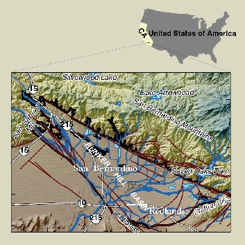
- Advance understanding of the hydrologic processes governing the shallow, mostly fine-grained hydrogeologic unit located in the historical discharge area of the Bunker Hill basin. In particular, quantify the relation between the shallow system and the underlying valley-fill aquifer. This hydrogeologic setting is common in the arid western United States and plays a major role in environmental issues involving soil liquefaction and maintenance of native vegetation.
- Provide unbiased data and results that will be used by the more than 20 water agencies in the area so that they can better resolve their multiple and continuing water issues.
- Provide water-resources information that will improve operation of local artificial-recharge basins, ground-water extractions, and ground-water cleanup facilities.
- Aid in protecting life and property in the San Bernardino area by providing hydrologic data and information. In particular, this study focuses on minimizing damage from possible soil liquefaction and land subsidence.
- Contribute to national databases used to develop and assess global climatological models.
Approach
Key aspects of the ground-water system will be verified to ensure accurate simulation with the existing ground-water-flow model. A surface-water distribution model will be designed and constructed. Critical water-quality problems and potential management options will be identified. A constrained optimization model will be developed that combines the surface-water and ground-water models with the water-quality issues. New methods of water management will be evaluated.
Significant Results
- Created the first real-time, ground-water-level monitoring wells in California. Pressure transducers measure ground-water levels every hour. Data is transferred via satellite every four hours to an internet accessible database.
- Identified vertical head gradients are downward over most of the basin. This result infers that near-surface contaminants will tend to migrate downward toward producing zones.
- Found that most ground water in the basin was recharged recently. Water samples from multiple-depth wells was found to have measurable tritium concentrations, indicating that at least some of the water was recharged fewer than 50 years ago.
- Developed a characteristic cross-section for the basin that includes geologic units, hydrogeologic units, geochemistry, and age of ground water.
- Created a comprehensive pumpage dataset for all wells in the basin for 1945-98.
- Created a geographic system (GIS) of geologic and hydrologic data.
- Determined that natural recharge can be mapped via satellites. InSAR images were created that showed a 3 to 7 cm rise in land-surface altitude resulting from abundant recharge in 1993.
- Initiated real-time basinwide monitoring as a way to facilitate management of the entire basin. Real-time monitoring include surface-water discharge at gaging stations and ground-water levels at multiple-depth well sites.
San Bernardino Optimal Basin Management
Welcome to the U.S. Geological Survey (USGS) San Bernardino Optimal Basin Management website. This site provides hydrologic data collected or compiled by the USGS in the San Bernardino area; some additional data may be available from the USGS database National Water Information System (NWIS).
Project Chief: Wes Danskin
Phone: 619-225-6132
Email: wdanskin@usgs.gov
Questions about Optimal Basin Management? Please contact Wes Danskin (email: wdanskin@usgs.gov or send a letter). 619.225.6132