Sustainable Groundwater
Groundwater-Level Declines
The California Department of Water Resources (DWR) has drafted Best Management Practices (BMPs) for monitoring groundwater levels. This USGS site includes information, tools, and data relevant to DWR's BMPs, and additional resources, to help water managers address key components of the required Groundwater Sustainability Plans (GSPs), including monitoring. Resources are listed on the Resources page of this site, and relevant resources are also listed in bullet points at the conclusion of each section.
Water-level measurements are the principal source of information about changes in groundwater storage and movement in a basin, and how these are affected by various forms of recharge (e.g., precipitation, seepage from streams, irrigation return) and discharge (e.g., seepage to streams, groundwater pumping).
Water-Level Monitoring Networks
Water-level monitoring is a fundamental way of gaining an understanding of a groundwater basin, determining directions of groundwater movement and trends in groundwater storage, and evaluating progress toward meeting water resource management goals. DWR advises that, in order to be SGMA compliant, each GSP must include a sufficient monitoring network to provide data needed to demonstrate progress toward achievement of the Plan’s sustainability goal.
Data obtained from monitoring-well networks can be used, along with other information or tools, to determine many aspects of groundwater systems, including:
- Directions of groundwater movement,
- The effect of withdrawals on recharge and natural discharge conditions,
- Hydraulic characteristics of aquifer-system materials, and
- The extent and degree of confinement of aquifers.
Wells in a water-level monitoring network for a GSP may have a variety of purposes, including those needed to monitor:
- Water-level changes over the lateral and vertical extent of aquifers;
- For exceedance of minimum thresholds associated with land subsidence, seawater intrusion, or other sustainability indicators; and
- The response of groundwater systems to water management actions, to determine the effectiveness of these actions.
Measuring Water Levels
Water-level monitoring involves "continuous" or periodic measurements. Continuous monitoring makes use of automatic water-level sensing and recording instruments that are programmed to make scheduled measurements in wells. This provides a high-resolution record of water-level fluctuations. Resulting hydrographs can accurately identify the effects of various stresses on the aquifer system and provide measurements of maximum and minimum water levels in aquifers. Continuous monitoring may be the best technique to use for monitoring fluctuations in groundwater levels during droughts and other critical periods when hydraulic stresses may change at relatively rapid rates, or when real-time data are needed for making water management decisions. Near-real-time data collection can be accomplished by adding telecommunication or radio transmitter equipment to a continuous monitoring site.
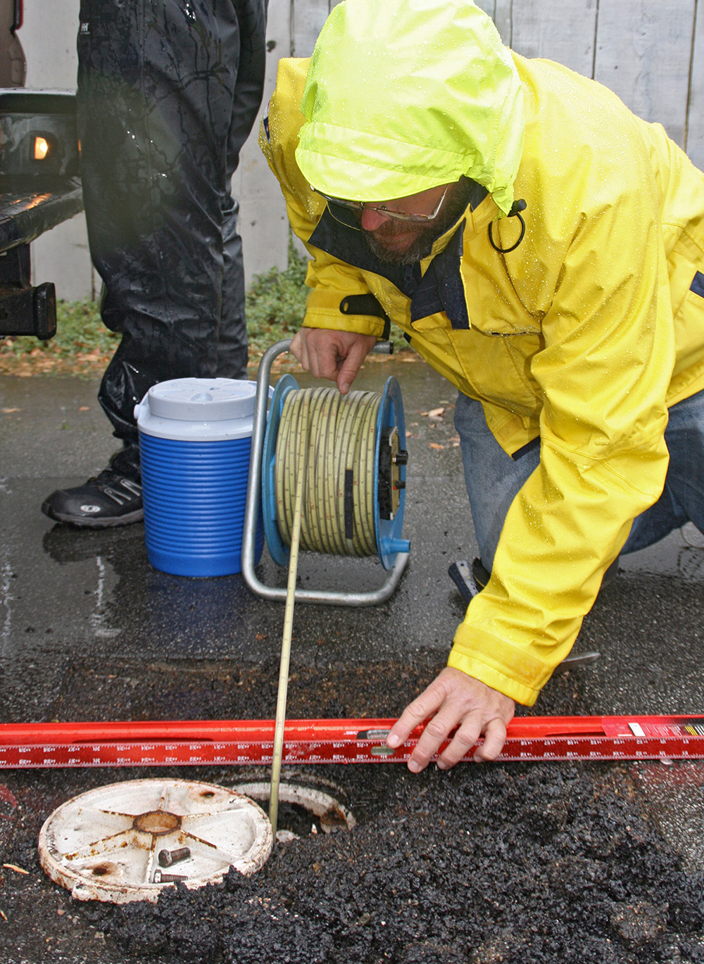
A USGS hydrologist conducts a manual water-level measurement in Santa Barbara, CA.
Water-level monitoring involves "continuous" or periodic measurements. Continuous monitoring makes use of automatic water-level sensing and recording instruments that are programmed to make scheduled measurements in wells. This provides a high-resolution record of water-level fluctuations. Resulting hydrographs can accurately identify the effects of various stresses on the aquifer system and provide measurements of maximum and minimum water levels in aquifers. Continuous monitoring may be the best technique to use for monitoring fluctuations in groundwater levels during droughts and other critical periods when hydraulic stresses may change at relatively rapid rates, or when real-time data are needed for making water management decisions. Near-real-time data collection can be accomplished by adding telecommunication or radio transmitter equipment to a continuous monitoring site.
The USGS has released a series of groundwater technical procedures documents (GWPDs) for general use by the public. These address the need for standardized technical procedures for applying groundwater science. To supplement these technical documents, USGS is producing aseries of videos demonstrating some of the technical procedures outlined in the GWPDs.
Approaches to Monitoring Network Design
A robust database from long-term systematic measurements of groundwater levels from a network of monitoring wells is ideal to evaluate changes in the resource over time, to develop groundwater models and forecast trends, and to design, implement, and monitor the effectiveness of groundwater management and sustainability programs.However, for a particular basin, sufficient water-level data may not exist, or current monitoring networks may need to be enhanced or expanded depending on program goals. Data gaps can result from monitoring information that is not of sufficient quantity or quality. It is important to clearly define what wells are needed to meet management objectives. When developing or expanding a monitoring program, a phased approach is often useful so that initial data can provide a better understanding of the groundwater-flow system and data limitations, and reveal where more information gathering is needed. This approach can yield a network with targeted aerial and depth distribution for pointed monitoring of aquifer system complexities. Moreover, it can allow for more efficient use of available funds and other resources.
- Groundwater-Level Monitoring and the Importance of Long-Term Water-Level Data
- Framework for Ground-Water Monitoring in the United States -- This Fact Sheet and report describe a collaborative effort between the USGS and State, Tribal and other local agencies to monitor groundwater levels and quality nationwide. Cooperating entities monitor wells in their regions, enter these data into local databases, and the relevant data are automatically made available as data queries are made. As part of this effort, data standards and tools were developed to make this possible.
- Statistical Design of Water-Level Monitoring Networks
- Design of Ground-Water Level Observation-Well Programs
- An Approach to the Design of Statewide or Regional Groundwater Information Systems
- Criteria for Groundwater Level Data Networks for Hydrologic and Modeling Purposes
- Optimization of Water-Level Monitoring Networks in the Eastern Snake River Plain Aquifer Using a Kriging-Based Genetic Algorithm Method
-- This USGS Circular, written in lay terms, describes the basics of groundwater-level monitoring and associated well networks, and includes many case studies demonstrating various approaches for monitoring a wide range of hydrologic settings.
-- This report describes the components of groundwater-level monitoring programs, including well selection, measurement frequency, quality assurance, and reporting of the data. It also describes the uses and importance of long-term data, and includes many case studies demonstrating these concepts.
This paper focuses on the design of well networks, and on specifically defining the objectives of each network and each well within the network for efficient groundwater management.
Developing a Water-Level Monitoring Network
Key components involved in developing a water-level monitoring network, or expanding an existing network, include:
- Defining the network objective,
- Selecting observation wells,
- Determining the frequency of water-level measurements,
- Establishing quality- assurance protocol, and
- Establishing effective practices for data reporting.
Selection of Observation Wells
Decisions made about the number and locations of observation wells are crucial to any water-level data collection program. Ideally, the wells chosen for an observation well network will provide data representative of various topographic, geologic, climatic, and land-use environments. Decisions about the areal distribution and depth of completion of observation wells also should consider the physical boundaries and geologic complexity of aquifers under study. Water-level monitoring programs for complex, multilayer aquifer systems may require measurements in wells completed at multiple depths in different geologic units. Large, regional aquifers that extend beyond State boundaries require a network of observation wells distributed among one or more States. If one of the purposes of a network is to monitor ambient groundwater conditions, or the effects of natural, climatic-induced hydrologic stresses, the observation network will require wells that are unaffected by pumping, irrigation, and land uses that affect groundwater recharge.
To find existing well-data for your area, the following resources are available:
- USGS National Water Information System: Mapper
- USGS California Real-Time Groundwater Level Network
- USGS Mojave Groundwater Data Map
- California Department of Water Resources (DWR): Groundwater Information Center
- DWR California Statewide Groundwater Elevation Monitoring (CASGEM) Program
Determining the frequency of Water-Level Measurements
The frequency of water-level measurements is among the most important components of a water-level monitoring program. Although often influenced by economic considerations, the frequency of measurements should be determined to the extent possible with regard to the anticipated variability of water-level fluctuations in the observation wells and the data resolution or amount of detail needed to fully characterize the hydrologic behavior of the aquifer.
Typically, collection of water-level data over one or more decades is required to compile a hydrologic record that encompasses the potential range of water-level fluctuations in an observation well and to track trends with time. Systematic, long-term collection of water-level data offers the greatest likelihood that water-level fluctuations caused by variations in climatic conditions and water-level trends caused by changes in land-use or water-management practices will be “sampled.” The availability of long-term water-level records greatly enhances the ability to forecast future water levels. Therefore, observation wells should be selected with an emphasis on wells for which measurements can be made for an indefinite time.
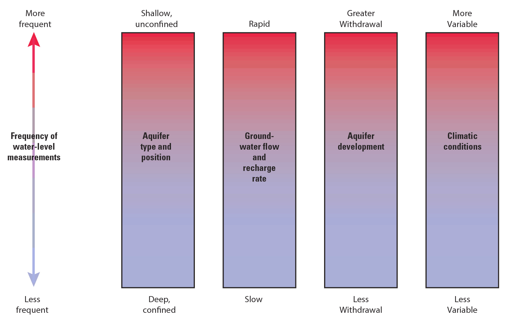
Common environmental factors that influence the choice of frequency of water-level measurements in observation wells.
Water-level data are collected over various lengths of time, dependent on their intended use(s). Short-term water-level data are collected over periods of days, weeks, or months during many types of groundwater investigations. For example, tests done to determine the hydraulic properties of wells or aquifers typically involve the collection of short-term data. Water-level measurements needed to map the altitude of the water table or potentiometric surface of an aquifer are generally collected within the shortest possible period of time so that hydraulic heads in the aquifer are measured under the same hydrologic conditions. Usually, water-level data intended for this use are collected over a period of days or weeks, depending on the logistics of making measurements at different observation-well locations.
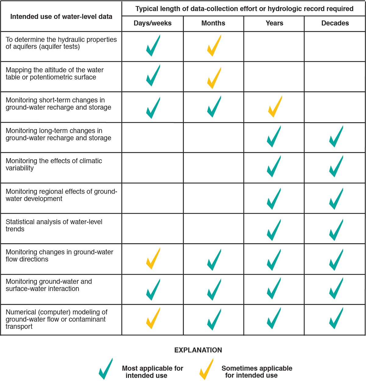
Typical length-of water-level data collection as a function of the intended use of the data.
Establishing Quality Assurance Protocols
Good quality-assurance practices help to maintain the accuracy and precision of water-level measurements, ensure that observation wells reflect conditions in the aquifer being monitored, and provide data that can be relied upon for many intended uses. Therefore, field and office practices that will provide the needed levels of quality assurance for water-level data should be carefully thought out and consistently employed.
Some important field practices that will ensure the quality of groundwater-level data include the establishment of permanent datums (reference points for water-level measurements) for observation wells, periodic inspection of the well structure, and periodic hydraulic testing of the well to ensure its communication with the aquifer. The locations and the altitudes of all observation wells should be accurately surveyed to establish horizontal and vertical datums for long-term data collection. Inaccurate datums are a major source of error for water-level measurements used as control points for contoured water-level or potentiometric surface maps and in the calibration and sensitivity analysis of numerical groundwater models. Advances in the portability and operation of traditional surveying equipment, and in Global Positioning System (GPS) technology, have simplified the process of obtaining a fast, accurate survey of well location coordinates and datums.
Existing wells selected and used for long-term water-level monitoring should be carefully examined to ensure that no construction defects are present that might affect the accuracy of water-level measurements. This may entail the use of a downhole video camera to inspect the well screen and casing construction. Over time, silting, corrosion, or bacterial growth may adversely affect the way the well responds to changes in the aquifer. Any well selected for inclusion in an observation network should be hydraulically tested to ensure it is in good communication with the aquifer of interest. Hydraulic tests should be repeated periodically to ensure that hydraulic communication between the well and the aquifer remains optimal and that the hydraulic response of the well reflects water-level (head) fluctuations in the aquifer as accurately as possible.
To help maintain quality assurance, a permanent file or database entry that contains a physical description of well construction, location coordinates, the datum used for water-level measurements, and results of hydraulic tests should be established for each observation well. Recent water-level measurements should be compared with previous measurements made under similar hydrologic conditions to identify potential anomalies in water-level fluctuations that may indicate a malfunction of measuring equipment or a defect in observation well construction.
Establishing effective practices for data reporting
Water-level data reporting techniques vary greatly depending on the intended use of the data. Simple tabulation is useful for the determination of average, maximum, and minimum water levels but does not easily reveal changes or trends caused by seasonal and annual differences in precipitation, water use, or other hydrologic stresses.
Water-level hydrographs—graphical plots showing changes in water levels over time—are a particularly useful form of data reporting. Such hydrographs provide a visual depiction of the range in water-level fluctuations, seasonal water-level variations, and the cumulative effects of short-term and long-term hydrologic stresses. In general, the value and reliability of the information presented by a water-level hydrograph improves with increasing frequency of measurement and period of record. Hydrographs that are constructed from infrequent water-level measurements, or that have significant gaps in time between the measurements, generally are difficult to interpret and may lead to biased or mistaken interpretations about the frequency and magnitude of water-level fluctuations and their causes. Depending on the frequency of water-level measurement and period of hydrologic record, water-level hydrographs can be constructed to illustrate historical water levels, compare recent and historical water-level data, and present descriptive statistics for water-level measurements.
Web-based Display of Monitoring Network Data
The accessibility of water-level data is greatly enhanced by the use of electronic databases, especially those that incorporate Geographic Information System (GIS) technology to visually depict the locations of observation wells relative to pertinent geographic, geologic, or hydrologic features. The availability of electronic information transfer on the Internet greatly enhances the capability for rapid retrieval and transmittal of water-level data to potential users. Water-level hydrographs, maps of observation-well networks, tabulated water-level measurements, and other pertinent information all can be configured for access on the Internet. A significant advantage of this method of data reporting is the ease and speed with which groundwater-level data can be updated and made available to users. As an example see USGS Mojave Groundwater Resources website.
Other Hydrologic Information
In addition to water levels, other types of hydrologic information are also important in order to carry out an effective water-level monitoring program. Data such as precipitation, streamflow, and water use can greatly enhance the interpretation of trends observed in water levels, and help explain changes in the storage and availability of groundwater that result from water withdrawals over time.
Modeling and Analysis
Water-level measurements serve as primary data for calibration and testing of groundwater flow models. Model development not only enhanced understanding of the groundwater-flow system, but also highlights the the limitations of existing water-level data, providing insights into the most critical needs for future water-level monitoring.
Combining USGS data with other quality-assured data can assist water managers and GSAs with basin-wide assessments and water-level mapping.
Long-Term Monitoring in Mojave River and Morongo Groundwater Basins
Since 1992, the USGS, in cooperation with the Mojave Water Agency, has constructed a series of regional water-table maps for intermittent years in a continuing effort to monitor groundwater conditions in the Mojave River and Morongo groundwater basins.
Water-level declines in this region have been associated with land subsidence. Spatially detailed maps of subsidence, measured using InSAR, were used to characterize land subsidence processes.
Mapping of water-level contours, water-level change, water-quality measurements, and numerous InSAR images were combined into an interactive map. Through monitoring and visualizing each of these components of the aquifer system, the USGS and Mojave Water Agency can better understand the interaction between them, and predict future trends.
Hydrologic Models to Study Water Availability in Cuyama Valley
Groundwater is the only source for domestic, agricultural and municipal water use in the Cuyama Valley groundwater basin in Santa Barbara County. Groundwater withdrawals, mainly to irrigate agricultural crops, have resulted in water-level declines of as much as 300 feet in the area since the 1940s. To plan for sustainable future use of the groundwater, the USGS, in cooperation with the Santa Barbara County Water Agency have established tools to allow users to plan for efficient use of the available groundwater resources. Data and analyses from the in-depth study of the geologic framework of Cuyama Valley’s aquifer system were used to update and improve a three-dimensional geologic and hydrologic framework of the Cuyama Valley basin, and associated hydrologic model. The hydrologic model is able to simulate a variety of potential future water-supply scenarios and assess associated relative changes in groundwater supply.
San Bernardino Valley Optimal Basin Management
The San Bernardino area of southern California has complex water-management issues. The USGS San Bernardino Optimal Basin Management website provides all data associated with seven multi-depth monitoring well installations, including site description, lithologic and geophysical logs, data from core samples, and links to the water-level and water-quality data.
TThis project will also support the development and calibration of a linked surface-water and groundwater flow model. Additional insight into water supply and water-quality problems will be gained from evaluation of the hydrologic system using the model in combination with the application of constrained mathematical optimization techniques.
Search All Resources >>
Have a SGMA science question or collaboration idea?
The USGS California Water Science Center works with Local, State and other Federal agencies to conduct studies that will help give water managers the knowledge they need to effectively allocate water resources under increasing demands.
USGS Data & Conditions
- Real-Time Data
- Streamflow
- WaterWatch
- USGS Data Mapper
- Groundwater
- Data | Watch | Regional
- Surface Water
- Data | Watch
- Water-Quality
- Data | Watch | Mapper
- USGS WaterNow
- Current-conditions for water data directly to your mobile phone or email.