Sustainable Groundwater
Groundwater-Storage Reductions
The California Department of Water Resources (DWR) has drafted Best Management Practices (BMPs) for monitoring groundwater storage.This USGS site includes information, tools, and data relevant to DWR's BMPs, and additional resources, to help water managers address key components of the required Groundwater Sustainability Plans (GSPs), including monitoring. Resources are listed on the Resources page of this site, and relevant resources are also listed in bullet points at the conclusion of each section.
Estimates of changes in groundwater storage rely heavily on the collection of groundwater level data and knowledge of the hydrogeologic properties of an aquifer system. Changes in groundwater storage can be estimated by using direct measurements such as measuring groundwater levels, and indirect measurements such as remote sensing, coupled with modeling tools.
Groundwater Levels
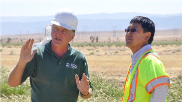
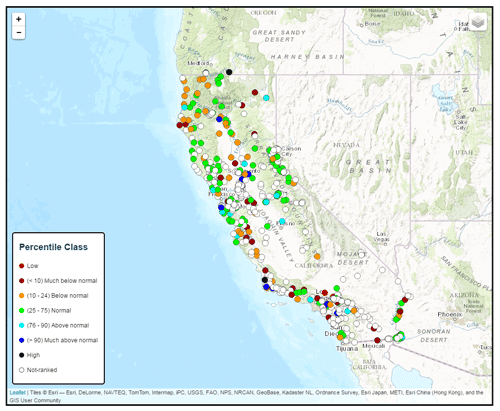
Groundwater-level measurements are the principal source of information about the hydrologic stresses acting on aquifers and how these stresses affect groundwater recharge, storage, and discharge.
Gravity Methods
Land-based, airborne, and satellite estimates of changes in groundwater storage are available. The National Aeronautics and Space Administration (NASA) mission, Gravity Recovery and Climate Experiment (GRACE) satellites, provides analysis results of differential gravity response associated with changes in groundwater occurrence and terrestrial water storage over large regions. These measurements are useful to rapidly show broad changes and trends across the landscape. Satellite estimates should be used cautiously, as they are more regional in nature and may not provide the level of accuracy necessary to fully determine the conditions within the basin, and may limit an agency’s ability to exercise the basin to meet sustainability goals defined by DWR.
Land-based gravity methods can measure changes in groundwater storage locally and are more accurate than satellite estimates. Gravity surveys offer a means to directly measure groundwater overdraft through measurement of changes in the gravitational field of the Earth, which are caused by changes in the amount of water stored in the subsurface.
Modeling and Analysis
Groundwater modeling tools, often part of integrated hydrologic models, are available to help water managers analyze historical and predict future storage changes as a result of various water-use scenarios. The successful application of a groundwater model requires the availability of sufficient groundwater-level data, and an understanding of the hydrologic and geologic characteristics of aquifers used for groundwater storage.
Central Valley Hydrologic Model (CVHM)
The CVHM is a regional three-dimensional (3D) computer model of the integrated hydrologic system of the Central Valley. The CVHM simultaneously accounts for changing water supply and demand across the landscape, and simulates surface water and groundwater flow and subsidence across the entire Central Valley. The model can be used by water managers to understand how water moves through the aquifer system, predict changes based on various water-supply and demand scenarios, and address specific issues related to water competition in the regional system. The CVHM has provided estimates of long term storage changes in different portions of the Valley.
- Central Valley Hydrologic Model (CVHM)
- Groundwater Availability of the Central Valley Aquifer, California
Borrego Valley Hydrologic Model (BVHM)
The Borrego Valley Hydrologic Model (BVHM) was developed to address the issue of groundwater availability in the Borrego groundwater basin. The BVHM is a tool that can be used to evaluate the effects of temporal changes in recharge and pumping, and to compare the relative effects of different water-management scenarios. Overall, the development of the BVHM, along with data networks and hydrologic analysis, provides a basis for assessing groundwater availability, groundwater storage changes, and potential water-resource management guidelines.
- The Borrego Valley Hydrologic Model (BVHM)
- Hydrogeology, Hydrologic Effects of Development, and Simulation of Groundwater Flow in the Borrego Valley, San Diego County, California
Pajaro Valley Hydrologic Model (PVHM)
Increasing population, agricultural development, and climate variability are placing increasingly larger demands on available groundwater resources in the Pajaro Valley, one of the most productive agricultural regions in the world. The Pajaro Valley Hydrologic Model (PVHM) reproduces the natural and human components of the region’s hydrologic system, as well as related climatic factors. This allows for an accurate assessment of groundwater conditions, and processes to inform revisions and updates to the area’s Basin Management Plan (BMP) for long-term sustainability of water resources.
Hydrologic Models to Study Water Availability in Cuyama Valley
Groundwater is the main source of water for domestic, agricultural, and municipal water use in the Cuyama Valley groundwater basin in Santa Barbara County. Groundwater withdrawals, mainly to irrigate agricultural crops, have resulted in water-level declines of as much as 300 feet in the area since the 1940s. To plan for sustainable future use of the groundwater, the USGS, in cooperation with the Santa Barbara County Water Agency, has established tools to allow users to efficiently utilize available groundwater resources. The hydrologic model is able to simulate a number of water-supply scenarios and assess possible changes in groundwater supply.
Managed Aquifer Storage and Recovery, Artificial Recharge
Managed aquifer storage and recovery, artificial recharge, and related water management practices are evolving rapidly to help meet present and future demands for water. There is great potential for managed aquifer storage and recovery, used in conjunction with other water management techniques, to make more efficient use of existing water resources and to reuse more water. To be effective, increasingly intensive management of water resources requires a greater knowledge and understanding of the hydrologic and geologic characteristics of aquifers used for water storage.
Injection, Storage, and Recovery Tests at Lancaster, Antelope Valley
To address concerns about storage depletion and subsidence in the Lancaster area of the Antelope Valley, the USGS, in cooperation with the Los Angeles County Department of Public Works (LACDPW) and the Antelope Valley–East Kern Water Agency (AVEK), conducted a series of freshwater injection, storage, and recovery tests in the area as part of a study to evaluate the feasibility of artificially recharging the groundwater system in the area. The USGS worked with LACDPW and AVEK to develop a better understanding of the aquifer system, assess the effects of injection, storage, and recovery on the aquifer system, and develop tools to help plan and manage a larger injection program.
Feasibility and Potential Effects of the Proposed Amargosa Creek Recharge Project, Palmdale, California
Historically, the city of Palmdale and vicinity has relied on groundwater as the primary source of water, owing, in large part, to the scarcity of surface water in the region. Despite recent importing of surface water, groundwater withdrawal for municipal, industrial, and agricultural use has resulted in groundwater-level declines near the city of Palmdale in excess of 200 feet since the early 1900s. To meet the growing water demand and replenish groundwater storage in the area, the city of Palmdale has proposed the Amargosa Creek Recharge Project (ACRP). The objective of this study was to evaluate the long-term feasibility of recharging the Antelope Valley aquifer system by using infiltration of imported surface water from the California State Water Project in percolation basins at the ACRP.
Lithostratigraphic, Borehole-Geophysical, Hydrogeologic, and Hydrochemical Data from the East Bay Plain, Alameda County, California
The USGS, in cooperation with the East Bay Municipal Utility District, carried out an investigation of aquifer-system deformation associated with groundwater-level changes at the Bayside Groundwater Project near the modern San Francisco Bay shore in San Lorenzo, California. As a part of the Bayside Groundwater Project, East Bay Municipal Utility District proposed an aquifer storage and recovery program for 1 million gallons of water per day. The potential for aquifer-system compaction and expansion, and related subsidence, uplift, or both, resulting from aquifer storage and recovery activities were investigated and monitored in the Bayside Groundwater Project. The results are being used to evaluate the chemical and mechanical responses of aquifers underlying the East Bay Plain to the future injection and recovery of imported water.
Search All Resources >>
Have a SGMA science question or collaboration idea?
The USGS California Water Science Center works with Local, State and other Federal agencies to conduct studies that will help give water managers the knowledge they need to effectively allocate water resources under increasing demands.
USGS Data & Conditions
- Real-Time Data
- Streamflow
- WaterWatch
- USGS Data Mapper
- Groundwater
- Data | Watch | Regional
- Surface Water
- Data | Watch
- Water-Quality
- Data | Watch | Mapper
- USGS WaterNow
- Current-conditions for water data directly to your mobile phone or email.