Sustainable Groundwater
Seawater Intrusion
The California Department of Water Resources (DWR) has drafted Best Management Practices (BMPs) for monitoring seawater intrusion. This USGS site includes information, tools, and data relevant to DWR's BMPs, and additional resources, to help water managers address key components of the required Groundwater Sustainability Plans (GSPs), including monitoring. Resources are listed on the Resources page of this site, and relevant resources are also listed in bullet points at the conclusion of each section.
Seawater intrusion associated with groundwater overdraft and lowering of groundwater levels has occurred in many of the coastal aquifers of the United States. The extent of seawater intrusion varies widely among localities and hydrogeological settings. Quantifying the extent and rate of seawater intrusion is key to sustainable management and use of groundwater resources. This involves understanding the aquifer-ocean interconnection, and distinguishing among multiple sources of saline water.
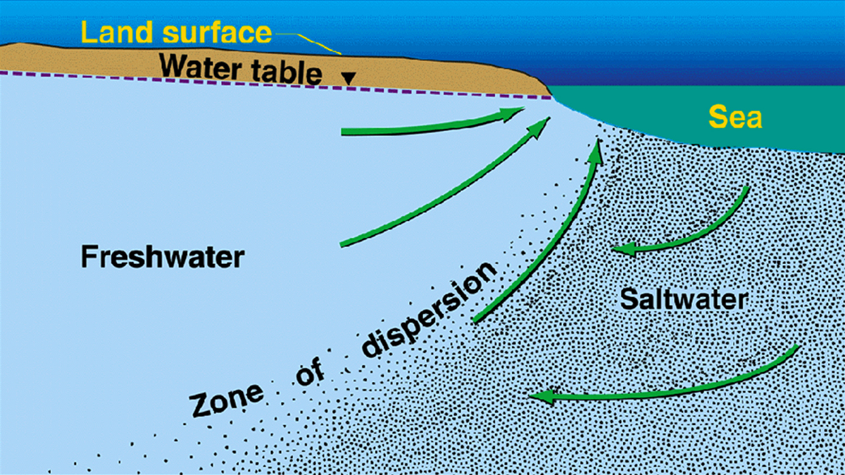
Groundwater flow patterns in an idealized, homogeneous coastal aquifer.
In general, under natural conditions, the seaward movement of freshwater prevents seawater from encroaching coastal aquifers. An interface between freshwater and seawater is maintained with denser seawater underlying freshwater. When groundwater is pumped from a coastal aquifer, lowered water levels can cause seawater to be drawn toward the freshwater zones of the aquifer. The intruding seawater decreases the freshwater storage in the aquifers. Without treatment, this groundwater does not conform to drinking-water or agricultural water-quality standards.
In real-world coastal conditions, the variability of hydrogeologic settings, three-dimensional distribution of saline water, and the history of groundwater withdrawals and freshwater drainage, results in a variety of modes of saltwater intrusion into coastal aquifers with varying complexities (See Los Angeles Basin examples on the Analysis tab).These include lateral intrusion from the ocean; upward intrusion from deeper, more saline zones of a groundwater system; and downward intrusion from coastal waters. Saltwater contamination may also occur along open boreholes and within abandoned, improperly constructed, or corroded wells that provide pathways for vertical migration across interconnected aquifers.
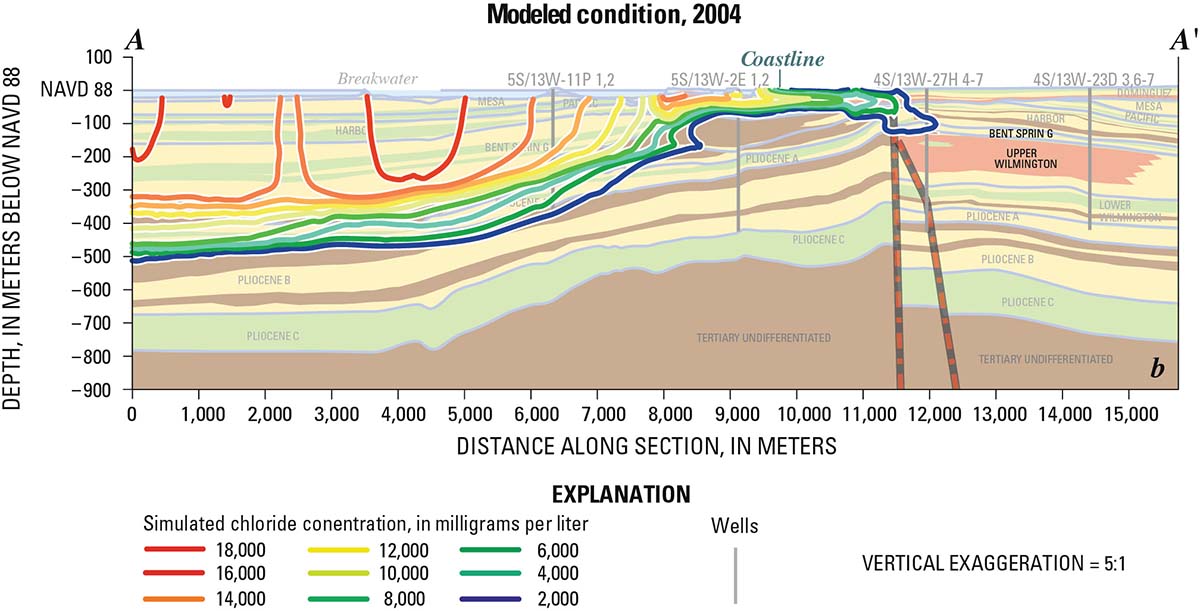
USGS studies show that the geology of the Los Angeles Basin is highly complex, as shown by this modeled figure of Los Angeles seawater intrusion. Dominguez Gap area stratigraphic profile Understanding this geology helps determine where and how fast water moves within the various beds of sediment both onshore and offshore to inform more effective management strategies.
The extent of saltwater intrusion into an aquifer depends on several factors, including the total rate of groundwater that is withdrawn from an aquifer compared to the total freshwater recharge to the aquifer; the distance between the locations of groundwater discharge – such as pumpage from wells and drainage to canals – and the sources of saltwater; the geologic structure of an aquifer or aquifer systems; the distribution of hydraulic properties of an aquifer; and the presence of fine-grained confining units that may limit saltwater from moving vertically toward or within the aquifer.
Potential pathways for seawater intrusion include hydraulic connection to aquifer beds exposed at the sea floor, flow along buried ancient stream channels, and flow through crushed rock in fault zones.
Related Resources
- Saltwater Intrusion in Los Angeles Area Coastal Aquifers—the Marine Connection
- Ground-Water Quality of Coastal Aquifer Systems in the West Coast Basin, Los Angeles County, California, 1999–2002
- Saltwater intrusion in coastal regions of North America
- Seawater Intrusion in a Coastal California Aquifer
- Freshwater-Saltwater Interactions along the Atlantic Coast
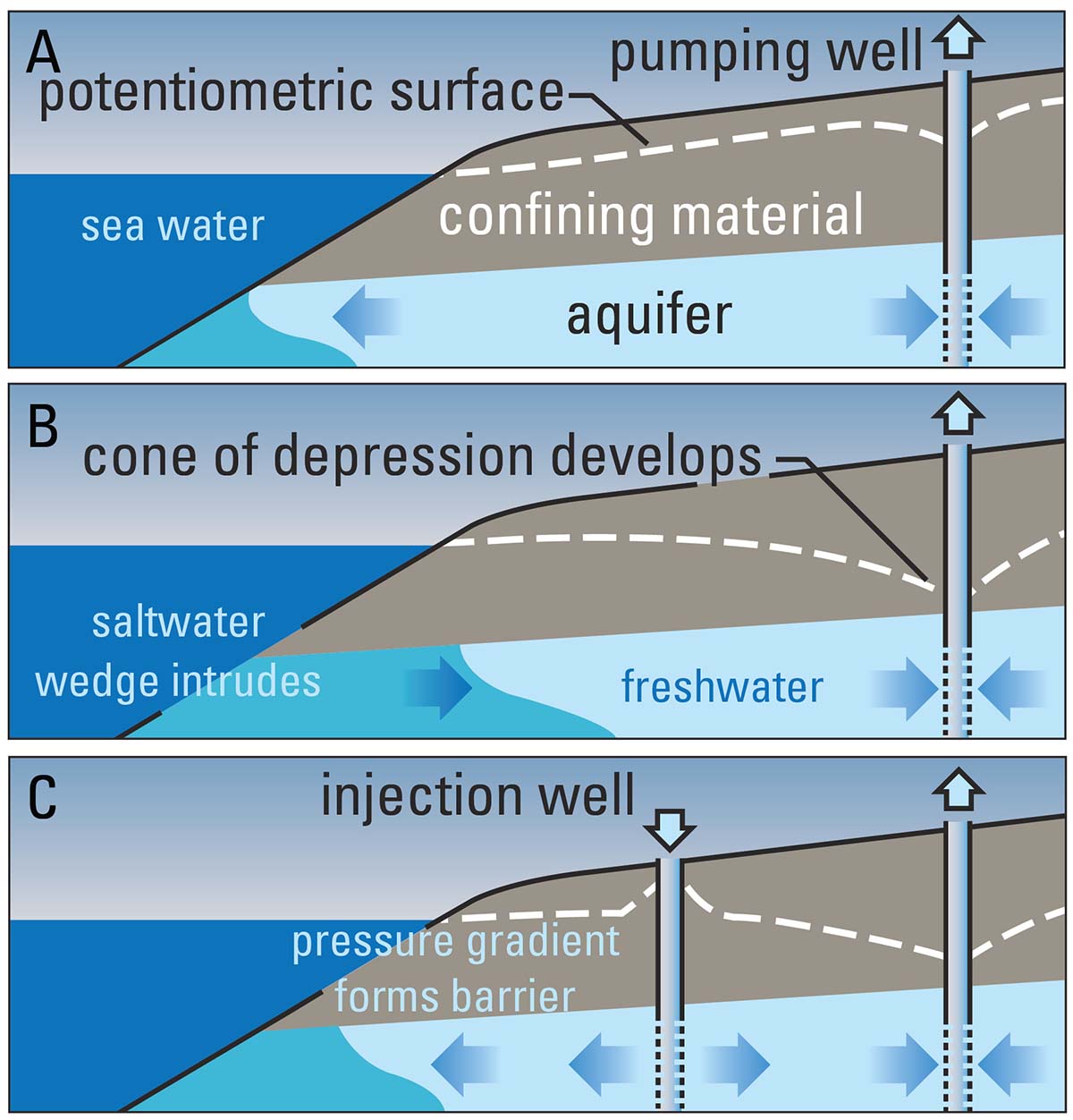
Conceptual figures of Los Angeles seawater intrusion: A. In Los Angeles in the 1800s, the potentiometric surface of groundwater (the levels to which pressure in the aquifer would make water rise in cased wells) was above sea level causing net seaward freshwater discharge from the aquifer. B. Potentiometric surface drops below sea level due to pumping as early as the 1920’s causing landward seawater intrusion into the aquifer. C. In the 1950’s sets of closely spaced wells were installed to inject high-quality fresh water into aquifers – ideally to stem the flow of seawater into coastal aquifers.
Monitoring Seawater Intrusion
Scientific monitoring and assessment provide basic characterization of the groundwater resources of an area, an understanding of the different pathways by which seawater may intrude an aquifer, and a basis for sustainable management of water supplies. Some common approaches for monitoring, often used in combination are: measuring depth-to-water (groundwater levels) and hydrograph analysis; water quality sampling; and, geophysical logging. Water-quality monitoring networks are particularly important to serve as early-warning systems of seawater movement toward freshwater supply wells, as well as providing information on the rates of seawater encroachment. Multiple-well monitoring sites that are designed with discrete, depth-dependent perforations are invaluable for providing a three-dimensional characterization of the extent of seawater within an aquifer system. These types of monitoring wells have been particularly important in the complex aquifer systems along the Pacific Coast, where saltwater may be present within relatively thin, discrete, coarse-grained zones.
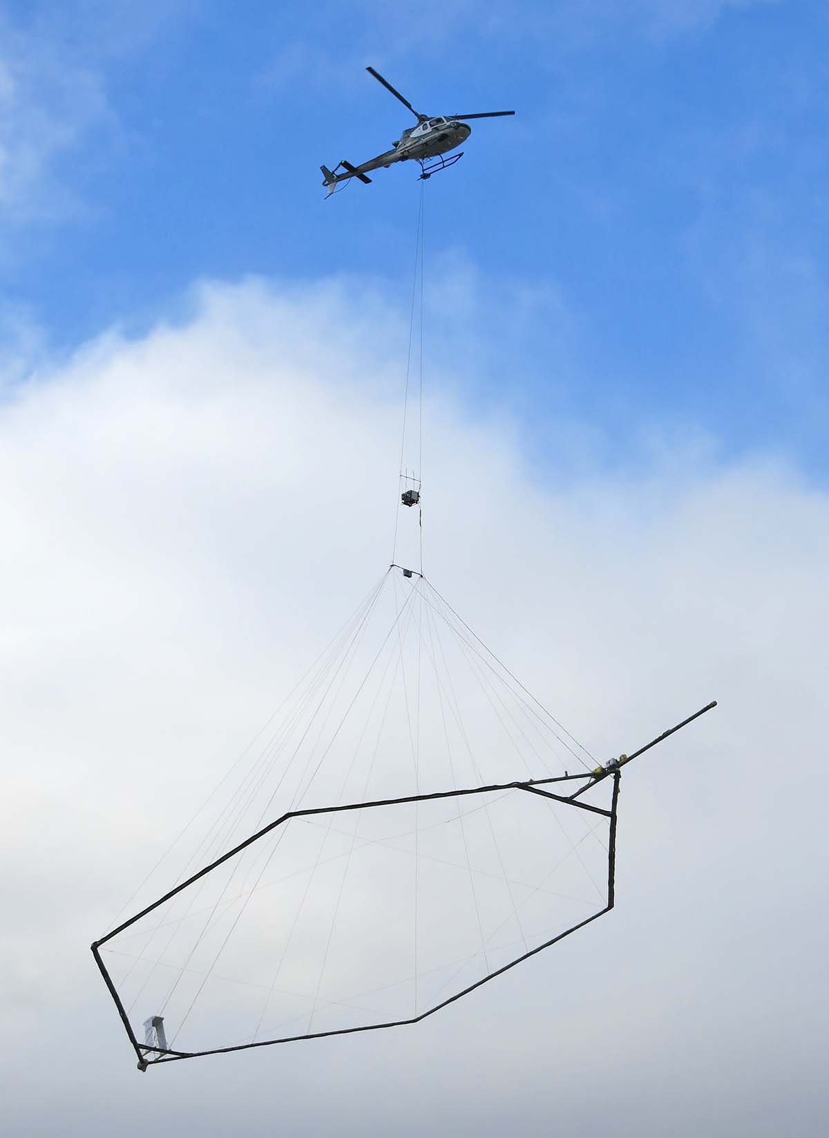
Airborne geophysical measurements can be used to map seawater intrusion. Because the helicopter can cover more than 100 miles in a day, the system is able to collect nearly continuous data over large areas and signals can potentially penetrate up to depths of 1,500 feet.
The traditional approach for monitoring the location and movement of saltwater contamination has been to periodically collect groundwater samples from discrete sampling horizons for analysis of the chloride or dissolved solids concentration of the water. Additional approaches include the use of borehole electromagnetic (EM) logs, which provide detailed vertical profiles of electromagnetic conductance, which can be correlated with salinity. Automated sample systems provide real-time monitoring of seawater intrusion. Recently, airborne (helicopter) electromagnetic measurements have been used to map electrical resistivity, which can be correlated with water quality and can provide valuable information for hydrologic modeling of seawater intrusion. While the data requires careful processing and interpretation, used with other geological/ hydrological information it can provide valuable input for characterizing seawater intrusion.
DWR advises resource managers to monitor seawater intrusion using chloride concentrations, or other measurements convertible to chloride concentrations, so that the current and projected rate and extent of seawater intrusion for each applicable principal aquifer may be calculated. DWR’s list of management practices that should be considered in order to provide data to support assessment of seawater intrusion can be found on page 13 of Monitoring Networks and Identification of Data Gaps: Best management practice.
Related Resources
- Electrical resistivity imaging of seawater intrusion into the Monterey Bay aquifer system
- Geophysical Mapping Of Saltwater Intrusion In Everglades National Park
- Chapter 7 Airborne Transient EM Methods and Their Applications for Coastal Groundwater Investigations
- Borehole Geophysical Logging of Water-Supply Wells in the Piedmont, Blue Ridge, and Valley and Ridge, Georgia
Modeling and Analysis
A number of computer codes exist for the simulation of seawater intrusion in coastal aquifers. In general, variable-density seawater intrusion models that track saltwater movement may be divided into sharp-interface and dispersive solute-transport models. In sharp-interface models, freshwater and seawater are assumed to be separated by an interface (for example, SHARP ( Essaid, 1990)). In dispersive solute-transport models, fluid density can vary continuously or from cell to cell in a model domain and transport resulting from hydrodynamic dispersion is simulated explicitly. Some programs solve the flow and transport equations simultaneously, such as, SUTRA (Voss and Provost, 2010) and FEFLOW (Diersch and Kolditz, 2002), MOCDENSE (Sanford and Konikow, 1995) and SEAWAT (Langevin and others, 2008).
USGS Seawater Intrusion related models and general flow models
- MODFLOW: USGS three-dimensional finite-difference groundwater model
- Seawater Intrusion (SWI2) Package for MODFLOW (USGS)
- SHARP: A quasi-three-dimensional, numerical finite-difference model to simulate freshwater and saltwater flow separated by a sharp interface in layered coastal aquifer systems
- SUTRA and related programs (SutraSuite)
- MOCDENSE: A two-constituent solute transport model for groundwater having variable density
- SEAWAT: A Computer Program for Simulation of Three-Dimensional Variable-Density Groundwater Flow and Transport
- FEFLOW: All-in-one groundwater modeling solution
- All USGS Water Resources Groundwater Software
Seawater Intrusion in Los Angeles
Groundwater pumping has led to extensive water-level declines and seawater intrusion in coastal Los Angeles, California. The USGS in cooperation with the Water Replenishment District of Southern California (WRD) has conducted detailed hydrogeologic modeling and analyses of chloride, as well as other constituents, to characterize the three-dimensional extent of seawater intrusion and the effectiveness of injection barrier operations.
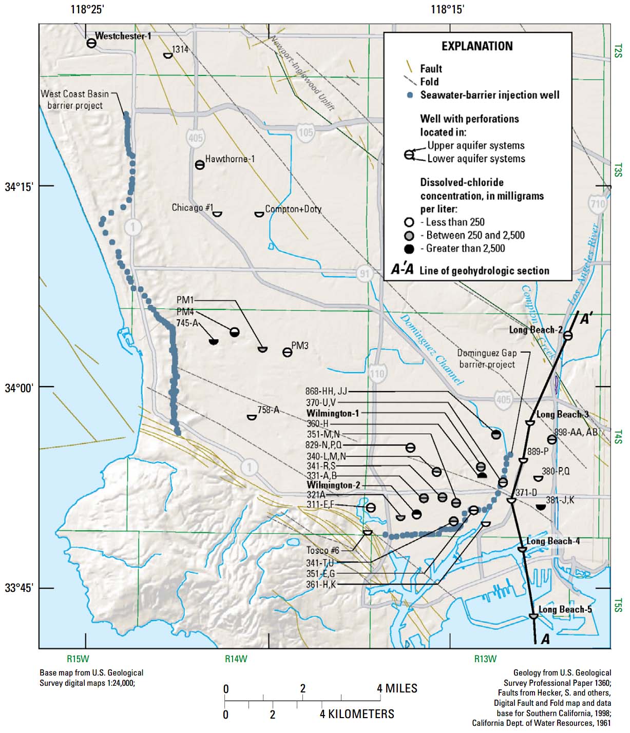
Results, dissolved chloride concentrations for wells sampled in the study area.
The USGS collected and analyzed data that described groundwater quality conditions of the major aquifer systems in the West Coast Basin, with an emphasis on the Dominguez Gap area. The scope of this study included (1) collecting and analyzing water samples for major- and minor-ion chemistry, trace elements, and various isotopes; (2) collecting and analyzing pore fluids at continuously cored monitoring sites; (3) characterizing lateral and vertical differences in ground-water chemistry; (4) interpreting the source, movement, and relative age of groundwater, with a focus on discriminating between native groundwater, seawater, injected water from the Dominguez Gap Barrier Project (DGBP), and oil-field brine; and (5) collecting and analyzing a suite of geophysical logs.
A few of the study results include:
- Elevated chloride concentrations were measured at many of the wells (in both the Upper and Lower aquifer systems) inland from the DGBP. Relatively low chloride concentrations were measured at several Lower aquifer system wells east of the DGBP. A review of historic data indicates that although many wells have had increasing water levels resulting from injection and decreased pumpage over the last 30 years, some of them do not show a corresponding decrease in dissolved chloride.
- Geophysical data, including EM-conductivity, temperature, and specific-conductance logs, provided an independent means for identifying high-salinity water and injection water. EM conductivity, combined with gamma-ray logs, identified likely saline zones along the entire well depth. This was especially valuable for identifying intruded zones that are not being monitored. EM logs from most wells in the Upper aquifer systems showed zones of elevated EM log conductivities; data were variable within the Lower aquifer systems. Several wells showed elevated EM conductivity in the uppermost part of the Lower aquifer systems. Because of the temperature differences between injection water, seawater, and the surrounding formations, temperature profiles provided additional information on zones affected by both injection water and intruding seawater.
Related Resources
- Saltwater Intrusion in Los Angeles Area Coastal Aquifers— the Marine Connection
- Ground-Water Quality of Coastal Aquifer Systems in the West Coast Basin, Los Angeles County, California, 1999–2002
- Characteristics of Southern California coastal aquifer systems
- Comparison of groundwater flow in Southern California aquifers
Stratigraphic Modeling for understanding seawater intrusion and groundwater management implications, Dominguez Gap area of Los Angeles, California

Map of Dominguez Gap study area.
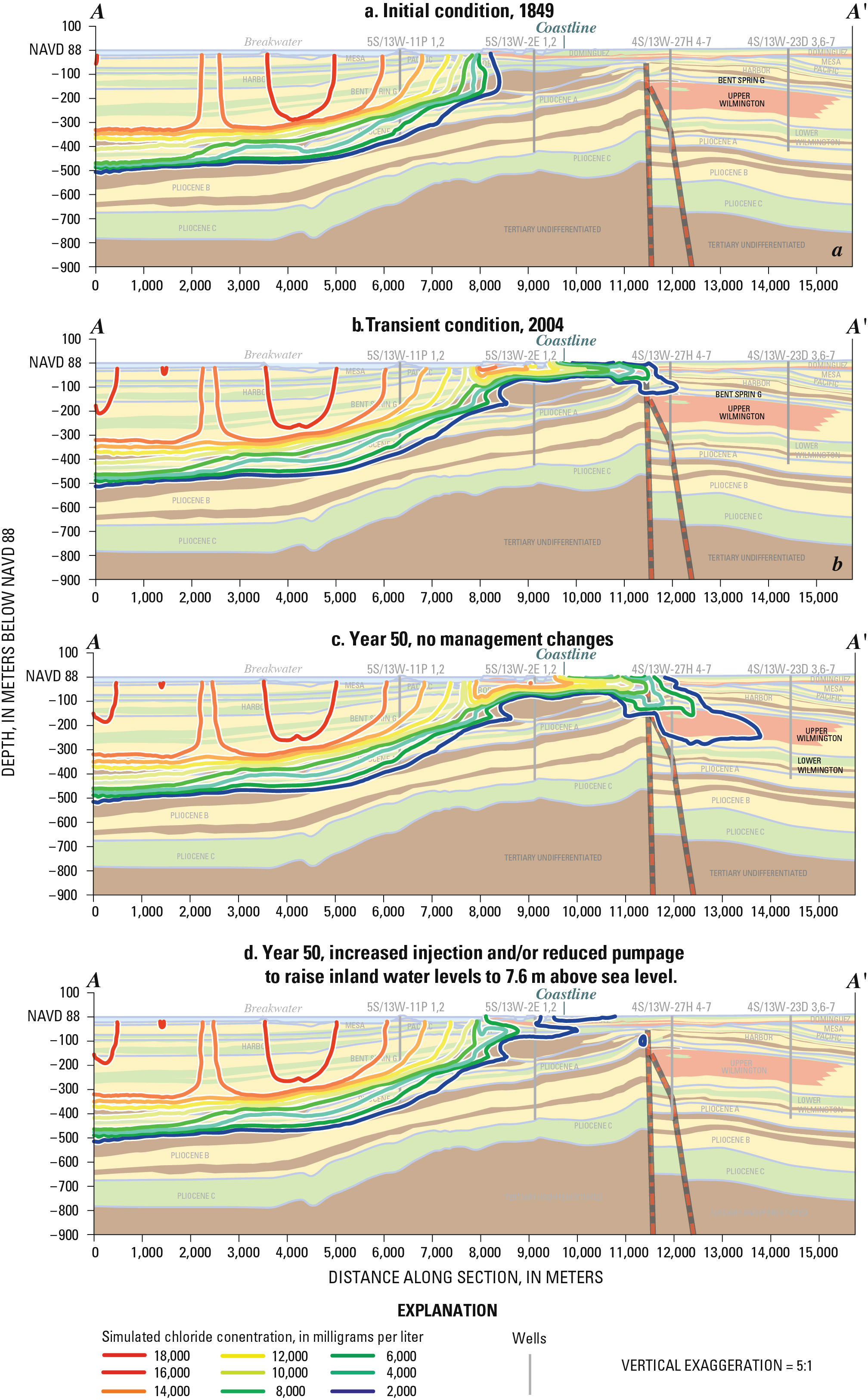
A selection of stratigraphic model results.
A SUTRA-based solute-transport model was developed to test the hydraulic implications of a sequence-stratigraphic model of the Dominguez Gap area and to assess the effects of water-management scenarios. The model is two-dimensional, vertical and follows an approximate flow line extending from the Pacific Ocean through the Dominguez Gap area. The modeling considered flow and transport along an approximate flow line; however, the true groundwater flow and transport system is three-dimensional.
Results indicate that a newly identified fault system can provide a pathway for transport of seawater and that a stratigraphic sequence boundary may control the vertical movement of seawater. Three 50- year water-management scenarios were considered: (1) no change in water-management practices; (2) installation of a slurry wall; and (3) raising inland water levels to 7.6m above sea level. Scenario 3 was the most effective by reversing seawater intrusion. The effects of an instantaneous 1-m sea level rise were also tested using water-management scenarios 1 and 3. Results from two 100-year simulations indicate that a 1-m sea-level rise may accelerate seawater intrusion for scenario 1; however, scenario 3 remains effective for controlling seawater intrusion.
Related Resources
- Stratigraphic controls on seawater intrusion and implications for groundwater management, Dominguez Gap area of Los Angeles, California, USA
- Geohydrology, Geochemistry, and Ground-Water Simulation-Optimization of the Central and West Coast Basins, Los Angeles County, California
- Saltwater intrusion in coastal regions of North America
- Geohydrologic Study of the Central and West Coast Basins of Los Angeles County
Have a SGMA science question or collaboration idea?
The USGS California Water Science Center works with Local, State and other Federal agencies to conduct studies that will help give water managers the knowledge they need to effectively allocate water resources under increasing demands.
USGS Data & Conditions
- Real-Time Data
- Streamflow
- WaterWatch
- USGS Data Mapper
- Groundwater
- Data | Watch | Regional
- Surface Water
- Data | Watch
- Water-Quality
- Data | Watch | Mapper
- USGS WaterNow
- Current-conditions for water data directly to your mobile phone or email.