Loading...
Legend
Mojave River Groundwater Basin (Mojave River area)
Morongo Groundwater Basin (Morongo area)
Mojave Water Agency Management Area
Mojave Water Agency Subareas
Morongo area subbasins
Township/Range/Sections
Mojave River
Mojave River Drainage Basin
Faults
Groundwater Data - 2016
Groundwater Data - 2014
Groundwater Data - 2012
Groundwater Data - 2010
Groundwater Data - 2008
Groundwater Data - 2006
Groundwater Data - 2004
Groundwater Data - 2002
Groundwater Data - 2000
Groundwater Data - 1998
Groundwater Data - 1996
Groundwater Data - 1994
Groundwater Data - 1992
Line Type: Dashed where approximately located; hachures indicate depression.
Water-level Contours - 2016
Water-level Contours - 2014
Water-level Contours - 2012
Water-level Contours - 2010
Water-level Contours - 2008
Water-level Contours - 2006
Water-level Contours - 2004
Water-level Contours - 2002
Water-level Contours - 2000
Water-level Contours - 1998
Water-level Contours - 1996
Water-level Contours - 1994
Water-level Contours - 1992
 Rise, > 30'
 Rise, > 15' - ≤ 30'
 Rise, > 5' - ≤ 15'
 Rise, > 0.5' - ≤ 5'
 Change ≤ 0.5'
 Decline, > 0.5' - ≤ 5'
 Decline, > 5' - ≤ 15'
 Decline, > 15' - ≤ 30'
 Decline, > 30'
El Mirage (Western)
Troy Lake/Newberry Springs (Central & Eastern)
Lucerne Lake (Central)
Coyote Lake (Central)
Harper Lake (Western & Central)
InSAR Study Images: 2014-2019
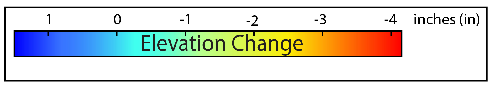
InSAR Study Images: 2004-2009
InSAR Study Images: 1999-2004
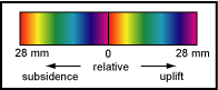
Contours of Subsidence for Selected InSAR Images
5mm10mm
15mm
20mm
25mm
Water-quality Data
Concentration symbology for Multiple Sample Point sites sometimes disappears while zooming. Click on the Multiple Sample Point of interest for detailed water quality information for individual sites.
Multiple Sample Points
Low
Moderate
High
Very High
Low
Moderate
High
Very High
Arsenic
Boron
Chromium (Total)
Dissolved Oxygen
Fluoride
Iron
Manganese
Nitrate plus Nitrite (as N)
Total Dissolved Solids (TDS)
Managed Recharge Sites
GPS Sites
Multi-Depth Well
Precipitation Stations
Surface Water Sites
Transducer Wells
Multi-port (Westbay) Well
Current Hydrograph Sites
Historical Hydrograph Sites
Perched Groundwater (Approx. area)
Perched-water Wells
Contours of Subsidence for Selected InSAR Images
Contours of subsidence are lines of equal displacement interpreted from InSAR intrerferograms. This technique is useful for the visualization of the extent and magnitude of subsidence in an area. The contour interval, which is the difference in subsidence between successive contour lines, is 5 mm.
Viewing the contours of subsidence for selected InSAR images
- Check the box next to the date of the desired subsidence contour in the "Contours of subsidence for selected InSAR images" column.
- Select the InSAR image with the corresponding date in the "View InSAR images" box. Note: not all InSAR images have been contoured.
- Click on the "Update Display" button and the display will zoom to the appropriate area(s).