Sustainable Groundwater
Interconnected Surface-Water Depletion
The California Department of Water Resources (DWR) has drafted Best Management Practices (BMPs) for monitoring interconnected surface-water depletions. This USGS site includes information, tools, and data relevant to DWR's BMPs, and additional resources, to help water managers address key components of the required Groundwater Sustainability Plans (GSPs), including monitoring. Resources are listed on the Resources page of this site, and relevant resources are also listed in bullet points at the conclusion of each section.
Surface water bodies interact with groundwater in all types of landscapes. This interaction takes place in three basic ways: surface-water bodies gain water from inflow of groundwater through their bed, they lose water to groundwater by outflow through the bed, or they do both, gaining in some reaches and losing in other reaches. For groundwater to discharge into a body, the altitude of the water table in the vicinity of the body must be higher than the altitude of the surface-water surface. Conversely, for surface water to seep into groundwater, the altitude of the water table in the vicinity of the stream must be lower than the altitude of the surface-water surface. Surface-water depletion is directly associated with chronic lowering of groundwater levels. Groundwater/surface-water interactions include the exchange of fluids and solutes, which can affect water quality and water supply.
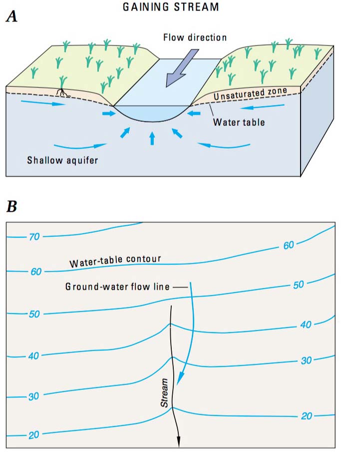
A. Gaining streams receive water from the groundwater system. B. This can be determined from water-table contour maps because the contour lines point in the upstream direction where they cross the stream.
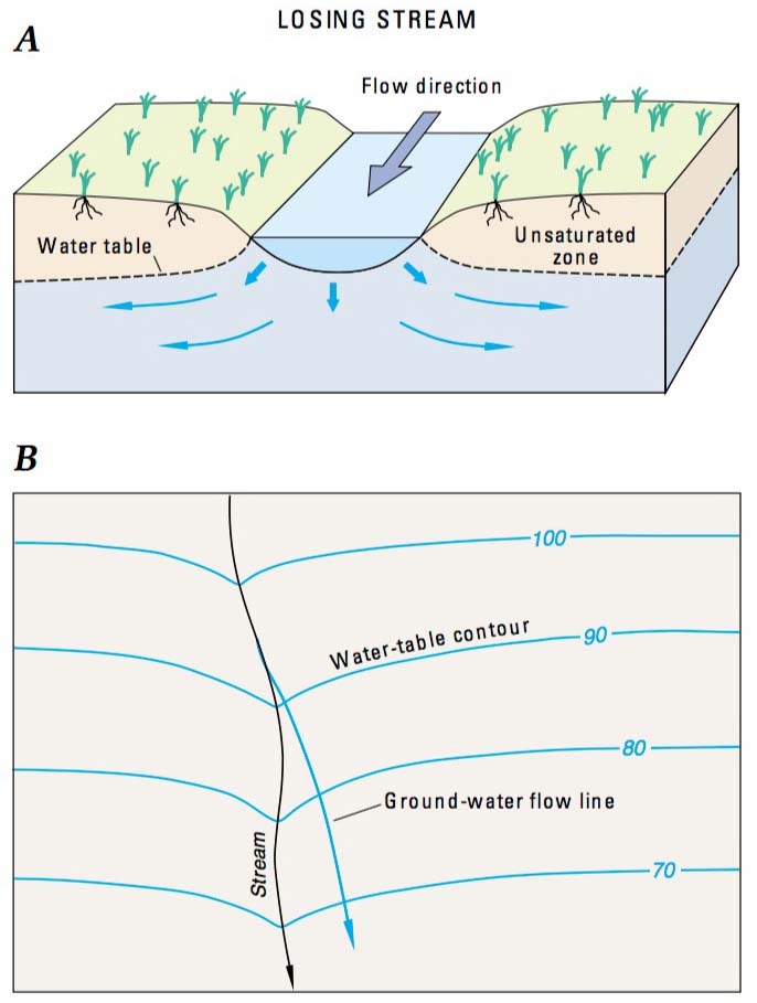
A. Losing streams lose water to the groundwater system. B. This can be determined from water-table contour maps because the contour lines point in the downstream direction where they cross the stream.
While natural processes like rainstorms and drought can impact surface-water/groundwater interactions, human-made processes also have a direct impact on this process:
- Pumping can intercept groundwater that would otherwise have discharged to a gaining stream, or, at higher pumping rates, it can induce flow from the stream resulting in the interception of surface water and the transformation of a gaining section to a losing section of the stream.
- Withdrawing water from shallow aquifers that are directly connected to surface-water bodies can have a significant effect on the movement of water between these two water bodies.
- Withdrawing water from shallow aquifers near surface-water bodies can diminish the available surface-water supply by capturing some of the groundwater flow that otherwise would have discharged to surface water, or intercepting surface water that would otherwise recharge the aquifer increasing the flow of surface water to the aquifer.
- Changes in the direction of water can impact both groundwater and surface water sources by changing the quantity of water exchanged, and also affect the transport of contaminants associated with the moving water.
Science-based assessments that include hydrologically connected surface water and groundwater components can help stakeholders design more comprehensive water management solutions.
Monitoring
DWR advises resource managers to monitor surface water and groundwater, where interconnected surface water conditions exist, to characterize the spatial and temporal exchanges between surface water and groundwater, and to calibrate and apply the tools and methods necessary to calculate depletions of surface water caused by groundwater extractions.
The effects of groundwater/surface-water exchange can occur on a variety of spatial and temporal scales. Various methods of data collection apply to fundamentally different areas and time periods. Conditions at the local and regional scale are often characterized based on measurements made at a few individual points. However, useful predictions based on point measurements are difficult because the characteristics of groundwater/surface-water exchange can vary over time and across a site or region.
Monitoring interconnected surface water depletions requires the use of tools — commonly modeling approaches — to estimate depletions associated with groundwater extraction. The USGS Office of Groundwater, Branch of Geophysics, evaluates the use of new or emerging hydrogeophysical tools and methods to improve understanding of groundwater/surface-water exchange. Methods based on electrical, thermal, and physical properties of exchange zones can efficiently locate and quantify interactions between groundwater and surface water. This spatially distributed information can tie point measurements to larger processes controlling flow and transport. This results in better ability to forecast movement of water between groundwater and surface-water bodies and associated changes in water quality and quantity.
DWR's list of management practices that should be considered in order to provide data to support assessment of interconnected surface water supplies can be found on page 18 of Monitoring Networks and Identification of Data Gaps: Best Management Practice.
Related Resources
- Standards for the Analysis and Processing of Surface-Water Data and Information Using Electronic Methods
- Measurement and computation of streamflow: Volume 1, Measurement of stage and discharge
- Measurement and computation of streamflow: Volume 2, Computation of Discharge
- USGS National Streamflow Information Program (NSIP)
- Website: Geophysics for USGS Groundwater/Surface-water Interaction Studies
Types of Equipment, Tools, and Methods Used in Recent Branch Applied Research:
- Heat tracing
- Electrical resistivity
- Electromagnetic
- Mobile/less-mobile porosity exchange
The USGS California Water Science Center operates a network of approximately 500 streamgages in the state that transmit near real-time data by satellite telemetry. Streamgage data are useful to understand the short and long-term status of specific streams. When combined with available groundwater pumping and monitoring data, streamgage data can help resource managers understand potential impacts from new or increased withdrawals from groundwater and surface-water sources.
Modeling and Analysis
Data and hydrologic models can help scientists and water resource managers better understand the effects sustainable groundwater use may have on the future of both groundwater and surface-water sources. The USGS uses various modeling software systems to analyze data and anticipate potential future scenarios that may be beneficial to creating a sustainable groundwater management plan.
- USGS Water Resources Groundwater Software (free, open-source)
Simulation of Aquifer Storage and Recovery in Pajaro Valley, Monterey Bay
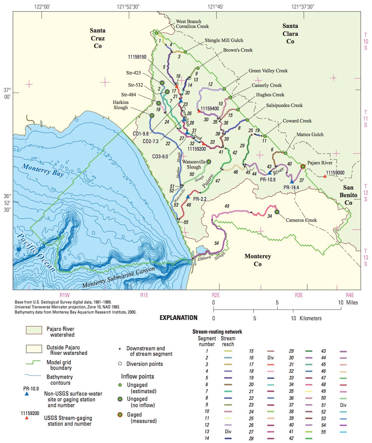
Parajo Valley stream network with streamflow routing cells and segments, streamgaging stations and other measurement sites, and location of inflows and diversion
Pajaro Valley, in Santa Cruz and Monterey Counties, is one of the most productive agricultural regions in the world. The USGS monitored and modeled the connection between groundwater flow systems, agricultural and municipal land use, streamflow networks, and groundwater pumping, to conceptualize the demands agricultural industries place on groundwater and surface-water resources and evaluating the potential impacts of this depletion as well as actions taken to mitigate the impact. Collecting data regarding the flow of groundwater, as well as the inflows from precipitation and streamflow of surface water, the USGS was able to create a conceptual model for the Pajaro Valley hydrologic cycle, and understand the effects of climate variability, agricultural demand, and increasing population on the rate of surface-water and groundwater depletion in growing urban areas
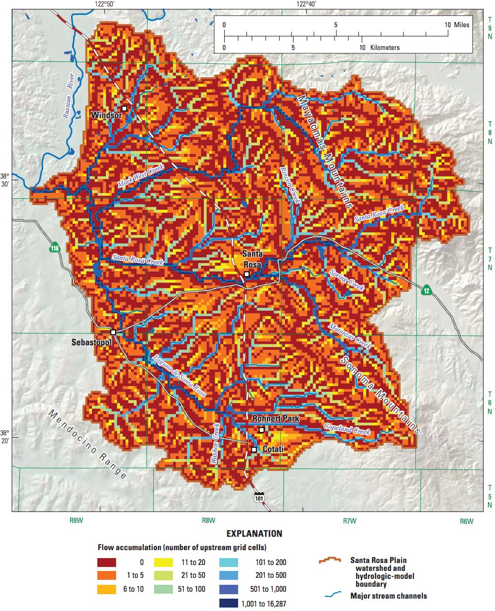
Simulation of Groundwater and Surface-Water Resources for the Santa Rosa Plain Watershed
In response to growing water demands in Sonoma County, the USGS developed a fully coupled surface-water and groundwater flow model of the Santa Rosa Plain watershed using the USGS groundwater and surface-water flow model, GSFLOW. The model was used to define hydrologic budget components and to evaluate the potential hydrologic effects of future climate and projected groundwater development on the basin.
GSFLOW consists of two integrated model components: (1) a watershed-component model developed by using Precipitation Runoff Modeling System (PRMS), and (2) a groundwater-component model developed by using the Modular Groundwater Flow Model MODFLOW-NWT. Development of a calibrated, coupled groundwater and surface-water flow model allows for analysis of the movement of water through the aquifer system, and the simulated effects of hydrologic stresses or potential stresses on the groundwater and surface-water systems. By using groundwater, precipitation, surface water, and streamgaging data, scientists were able to use GSFLOW software to create a groundwater and surface-water model to better understand and help manage the hydrologic resources in the Santa Rosa Plain watershed. The model was able to simulate potential future-climate scenarios to estimate the long-term effects of climate change and variability, with and without the estimated effects of groundwater pumping.
Cascade flow-routing network for the watershed-component model, Santa Rosa Plain watershed.
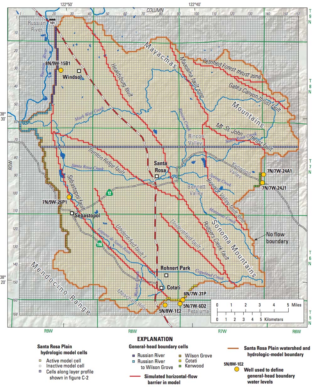
Model grid, boundary conditions, profile row, and location of horizontal-flow barriers in the groundwater component of the Santa Rosa Plain hydrologic model.
Scientists use hydrologic models like the Santa Rosa Plain model to determine hydrologic changes given climate change, with and without pumping. In regard to the Santa Rosa Plain model, for water years 2011 to 2040, model results generally show that higher pumping rates based upon future-climate scenarios may cause further groundwater level declines, and associated reductions in groundwater discharge to streams and groundwater evapotranspiration. The model also shows an increase in the number of stream reaches with streamflow losses. Model results for different climate conditions without pumping for water years 2011 to 2099 indicated greater variability in total streamflow, higher frequency of low streamflows, a shift in the timing of maximum streamflows from December to February, and a decrease in evapotranspiration due to depletion of groundwater resources compared to historical conditions.
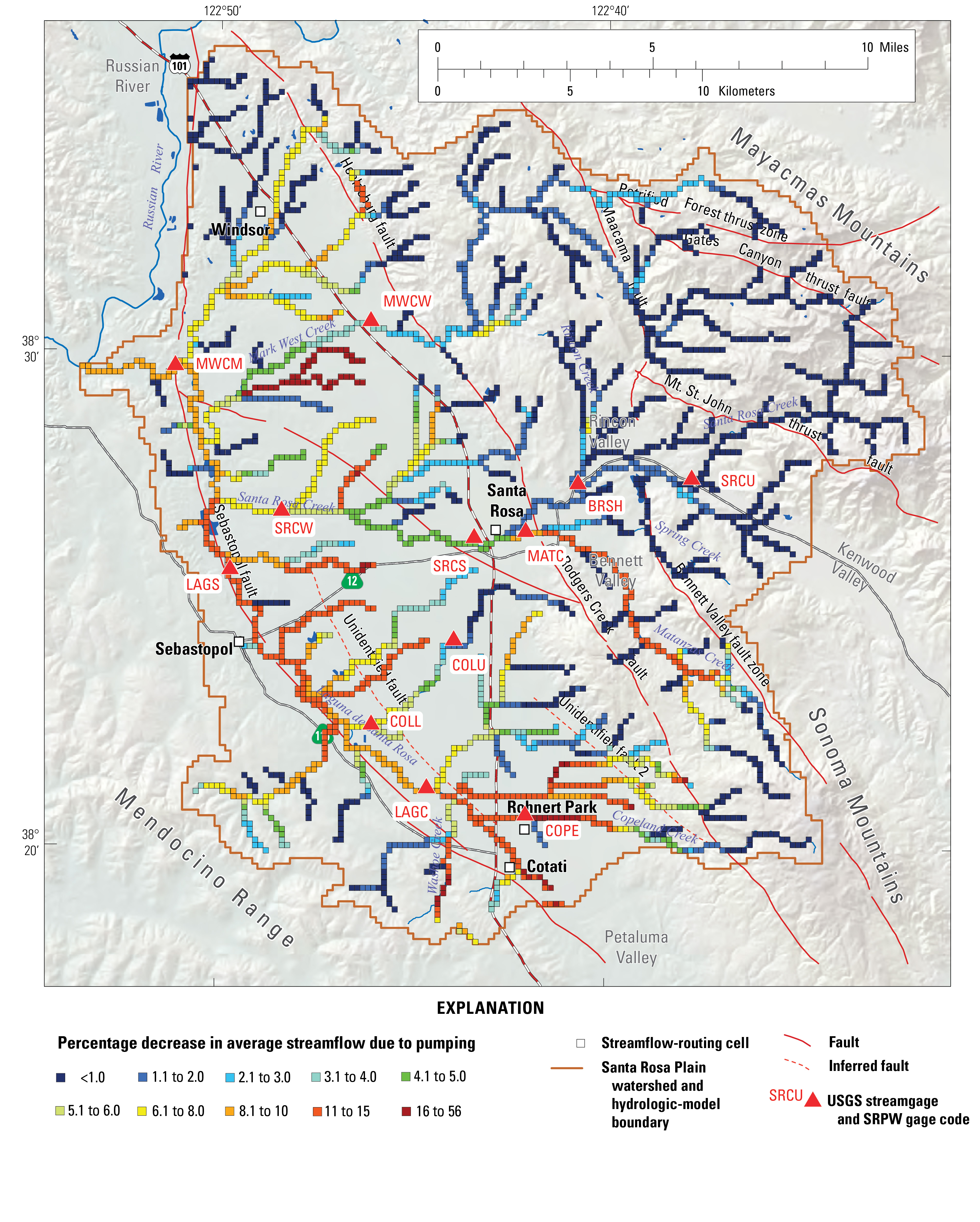
Changes in percent streamflow due to pumping, water years 1976-2010.
The Santa Rosa Plain hydrologic model – and other groundwater and surface-water flow models – is a tool that can be used for simulating hydrologic responses to various changes in stresses to the groundwater and surface-water flow systems. These models can also be used as a platform to connect the simulation of hydrologic processes with water-allocation and optimization models. Models can be used to provide water budgets, investigate the stream and aquifer interaction, and to simulate the effects of current hydrologic stress, potential climate change, and projected groundwater pumping stresses on the hydrologic system. Knowledge of the current and potential future states of a surface-water and groundwater interaction is essential to establishing a sustainable groundwater management plan.
Simulation of Aquifer-Stream Interaction in the San Joaquin River Restoration Program Study Area
To better understand the potential effects of restoration flows on existing drainage problems, anticipated as a result of the San Joaquin River Restoration Program (SJRRP), the USGS in cooperation with the U.S. Bureau of Reclamation developed a groundwater flow model (SJRRPGW) of the SJRRP study area that is within 5 miles of the San Joaquin River and adjacent bypass system from Friant Dam to the Merced River. The primary goal of the SJRRP is to reestablish the natural ecology of the river to a degree that restores salmon and other fish populations. Increased flows in the river, particularly during the spring salmon run, are a key component of the restoration effort. A potential consequence of these increased river flows is the exacerbation of existing irrigation drainage problems along a section of the river between Mendota and the confluence with the Merced River. Historically, this reach typically was underlain by a water table within 10 feet of the land surface, thus requiring careful irrigation management and (or) artificial drainage to maintain crop health. The SJRRPGW is designed to meet the short-term needs of the SJRRP; future versions of the model may incorporate potential enhancements, several of which are identified in this report.
The SJRRPGW was constructed using the USGS groundwater flow model MODFLOW and was built on the framework of the USGS Central Valley Hydrologic Model (CVHM) within which the SJRRPGW model domain is embedded. The Farm Process (FMP2) was used to simulate the supply and demand components of irrigated agriculture. The Streamflow-Routing Package (SFR2) was used to simulate the streams and bypasses and their interaction with the aquifer system. The 1,300-square mile study area was subdivided into 0.25-mile by 0.25-mile cells. The sediment texture of the aquifer system, which was used to distribute hydraulic properties by model cell, was refined from that used in the CVHM to better represent the natural heterogeneity of aquifer-system materials within the model domain. In addition, the stream properties were updated from the CVHM to better simulate stream-aquifer interactions, and water-budget subregions were refined to better simulate agricultural water supply and demand. External boundary conditions were derived from the CVHM.
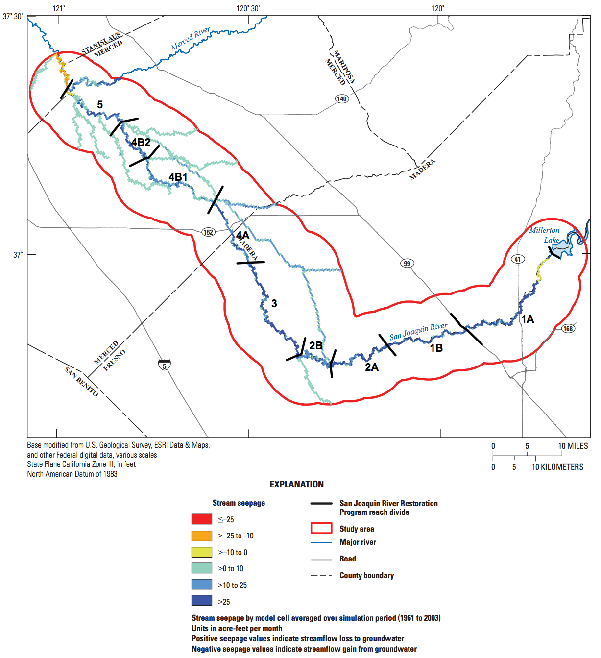
San Joaquin River Restoration Program groundwater flow model (SJRRPGW) average groundwater and surface-water interaction, San Joaquin Valley, California.
The model's Streamflow-Routing Package (SFR2) calculates the stream stage on the basis of the streambed elevation, flow in the stream, and other stream hydraulic characteristics. SFR2 uses this stream stage to calculate the hydraulic gradient between the stream and the model cell representing the top of the aquifer system underlying the stream. If the stream stage is above the head in the cell (positive hydraulic gradient), the stream loses water to the aquifer system; conversely, if the steam stage is below the head in the cell (negative hydraulic gradient), the stream gains water from the aquifer system.
Have a SGMA science question or collaboration idea?
The USGS California Water Science Center works with Local, State and other Federal agencies to conduct studies that will help give water managers the knowledge they need to effectively allocate water resources under increasing demands.
USGS Data & Conditions
- Real-Time Data
- Streamflow
- WaterWatch
- USGS Data Mapper
- Groundwater
- Data | Watch | Regional
- Surface Water
- Data | Watch
- Water-Quality
- Data | Watch | Mapper
- USGS WaterNow
- Current-conditions for water data directly to your mobile phone or email.