Sustainable Groundwater
Sustainable Groundwater Management
In 2014, the State of California adopted historic legislation to help manage its groundwater, the Sustainable Groundwater Management Act (SGMA) . According to the act, local Groundwater Sustainability Agencies (GSAs) must be formed for all high and medium priority basins in the state. These GSAs must develop and implement Groundwater Sustainability Plans (GSPs) for managing and using groundwater without causing undesirable results: significant groundwater-level declines, groundwater-storage reductions, seawater intrusion, water-quality degradation, land subsidence, and surface-water depletions; these are also referred to as sustainability indicators.
The California Department of Water Resources (DWR) and the State Water Resources Control Board (Water Board) are the two lead state Agencies implementing SGMA. The U.S. Geological Survey (USGS) conducts a broad range of technical activities to support the GSAs, DWR, and the Water Board.
The USGS uses data collection, modeling tools, and scientific analysis to help water resource managers plan for, and assess, hydrologic issues associated with groundwater use, including the SGMA sustainability indicators. This information helps managers understand trends and investigate and predict effects of different groundwater management strategies.
Sustainability Indicators
SGMA requires GSAs to develop and implement Groundwater Sustainability Plans (GSPs) for managing and using groundwater. Each GSP must consider the following sustainability indicators:
Groundwater-Level Declines
Long-term declines in groundwater levels occur when groundwater withdrawals exceed recharge of the aquifer system. Such declines are indicative of unsustainable groundwater use, and are the primary cause of the other sustainability indicators, described below.
Land Subsidence
Extensive groundwater withdrawals from aquifer systems have caused land subsidence in many California basins. Land subsidence can damage structures such as wells, buildings, and highways. They also can create problems in the design and operation of facilities for drainage, flood protection, and water conveyance. Groundwater-level and land-subsidence monitoring provide the information needed to guide mitigation efforts and management of future effects.
Seawater Intrusion
Seawater intrusion associated with lowering of groundwater levels is an important issue in many of California's coastal groundwater basins. Quantifying the rate and extent of seawater intrusion involves understanding the aquifer–ocean interconnection and distinguishing among multiple sources of saline water.
Groundwater-Storage Reductions
Long-term declines in groundwater levels, if predominant within a basin and not offset by rising groundwater levels, cause long-term reductions in groundwater storage. Changes in groundwater storage can be estimated by using direct measurements, such as measuring groundwater levels, and indirect measurements, such as remote sensing, coupled with modeling tools.
Interconnected Surface-Water Depletions
Groundwater and surface water are interconnected resources. Much of the flow in streams, and the water in lakes and wetlands, is sustained by the discharge of groundwater, particularly during dry periods. Coordinated measurement and modeling of surface and groundwater conditions generally are needed to estimate surface-water changes that result from groundwater development.
Water-Quality Degradation
Determining changes in groundwater quality over time, often associated with changing groundwater levels, involves systematic monitoring of constituents of concern, coupled with understanding of the dynamics of the groundwater-flow system.
Planning Tools
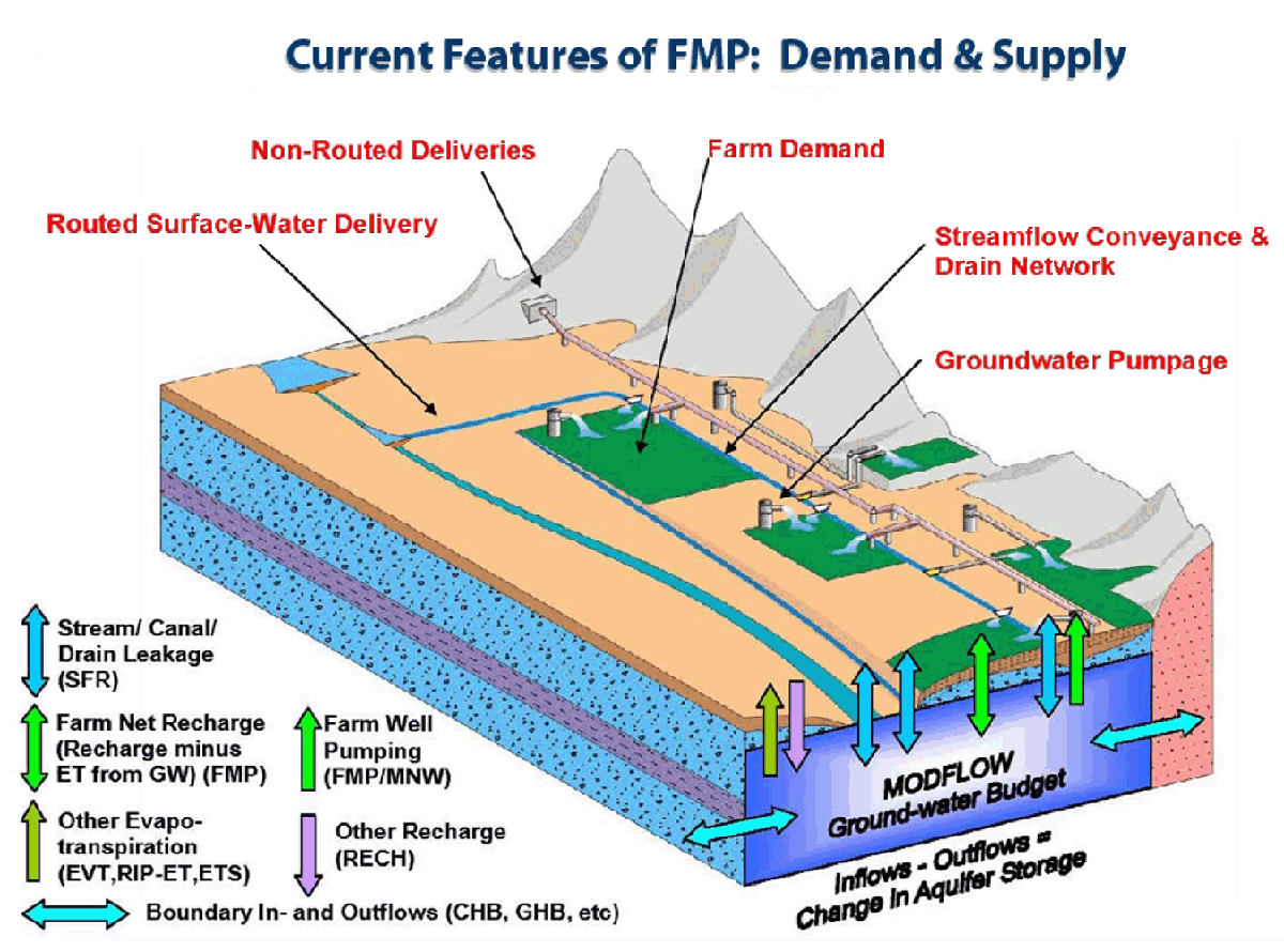
Modeling
Computational models, including computer simulation, are used to represent hydrologic processes, including the movement and use of water. They take into account components of the landscape, aquifer system, and water cycle, and provide a framework to organize data, knowledge, and understanding of hydrologic systems. Models can be helpful tools to help water-resource managers plan effectively for future water demands and answer scientific, planning and operational questions.
Data
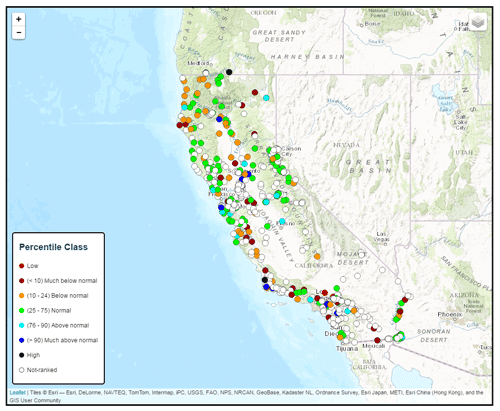
Groundwater-level monitoring is a fundamental way of gaining an understanding of a groundwater basin, determining directions of groundwater movement and trends in groundwater storage, and evaluating progress toward meeting water resource management goals. DWR advises that, in order to be SGMA compliant, each GSP must include a sufficient monitoring network to provide data needed to demonstrate progress toward achievement of a plan's sustainability goal.