Water-Level Studies in the Antelope Valley and Fremont Valley Groundwater Basins
Antelope Valley and Fremont Valley Study Area
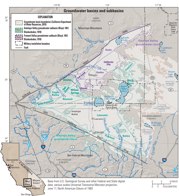
Map of the study area in relation to the Antelope Valley and Fremont Valley groundwater basins.
The Antelope Valley (6-044) and Fremont Valley (6-046) groundwater basins (California Department of Water Resources, 2021) are in the western part of the Mojave Desert, northeast of Los Angeles. The Antelope Valley and Fremont Valley groundwater basins together encompass about 2,100 square miles. The climate of these basins is typical of the Mojave Desert region of southern California; average annual precipitation for the period 1974-2012 was 7.39 in. (Western Regional Climatic Center, 2012) and recharge to the groundwater system from direct infiltration of precipitation is negligible (Snyder, 1955; Durbin, 1978).
Surface water in these basins is minimal and normally is limited to ephemeral flow (flow in a river or stream that only occurs during and immediately after rain or snow-melt) during winter and spring storms and discharge from ephemeral springs originating in the Tehachapi and San Gabriel Mountains. The primary source of groundwater recharge is runoff and infiltration of stormflow from the San Gabriel Mountains to the south. The lack of reliable surface-water resources has resulted in the use of groundwater as the primary source for private, agricultural, and municipal supply in the groundwater basins. Because of increasing urbanization and demands on local water supplies, groundwater levels have declined over time.
The boundaries of the Antelope Valley and the Fremont Valley groundwater basins generally are defined by the contact between the water-bearing unconsolidated deposits and the surrounding and underlying non-water-bearing consolidated igneous and metamorphic rocks. For water-management purposes, the Antelope Valley and Fremont groundwater basins were previously divided by Weir and others (1965) and Bloyd (1967) into 14 groundwater subbasins, partially based on geology. The boundary between the Antelope Valley and Fremont Valley groundwater basins, as defined by the California Department of Water Resources (2021), is located along a southeastward-trending groundwater divide starting from the mouth of Oak Creek (California Department of Water Resources, 2004). This dividing boundary cuts across two groundwater subbasins: Gloster and Oak Creek.
Groundwater Basins
Antelope Valley Groundwater Basin
The Antelope Valley groundwater basin is approximately 1,580 square miles and extends from the San Gabriel Mountains in the south to north of Rogers Lake (dry). The groundwater basin is bounded on the northwest by the Garlock fault zone at the base of the Tehachapi Mountains and on the southwest by the San Andreas fault zone at the base of the San Gabriel Mountains. The groundwater basin is bordered on the east by the El Mirage Valley, Harper Valley, and Middle Mojave River Valley groundwater basins. In the north the Antelope Valley basin is bounded by the Fremont Valley groundwater basin. The Antelope Valley groundwater basin as defined by the California Department of Water Resources (2021) encompasses nine groundwater subbasins (Lancaster, Buttes, Pearland, Neenach, West Antelope, Finger Buttes, North Muroc, Willow Springs, and Peerless), and parts of two groundwater subbasins (Oak Creek and Gloster).
Quaternary alluvium and lacustrine deposits form the primary water-bearing deposits in the Antelope Valley groundwater basin. The groundwater system consists of three aquifers: lower, middle, and upper aquifers (Leighton and Phillips, 2003). The upper aquifer is generally unconfined, except in areas such as the area north of Little Rock Wash and around Rogers Lake where fine-grained, low-permeability lacustrine deposits are part of the upper aquifer (Leighton and Phillips, 2003). Siade and others (2014) separated the upper aquifer into two aquifers to account for a laterally extensive clay interbed. The upper and middle aquifers are separated by lacustrine deposits or laterally discontinuous interbeds of relatively low permeability, fine-grained deposits of the upper aquifer (Leighton and Phillips, 2003). The lower aquifer is confined by the lacustrine deposits and the middle aquifer (Leighton and Phillips, 2003). In areas around Palmdale and Lancaster, the lacustrine deposits may be partly contained within the lower aquifer (Leighton and Phillips, 2003). Bedrock commonly contains groundwater but is not considered a reliable source of groundwater in the study area.
The primary source of groundwater recharge in the Antelope Valley groundwater basin is mountain-front recharge (Siade and others, 2014). Estimates of mountain-front recharge range from about 29,000 acre-ft/yr (Siade and others, 2014) to 58,000 acre-ft/yr (Bloyd, 1967). Anthropogenic sources of groundwater recharge include irrigation-return flow, recharge of treated wastewater through surface spreading, and urban-return flow (Siade and others, 2014). Siade and others (2014) reported maximum simulated values of 120,000, 7,000, and 45,000 acre-ft/yr for irrigation-return flow, treated wastewater, and urban-return flow, respectively. Historically, groundwater in the Antelope Valley groundwater basin flowed north from the San Gabriel Mountains and south and east from the Tehachapi Mountains toward Rosamond Lake, Rogers Lake, and Buckhorn Lake (California Department of Water Resources, 2004).
The primary source of groundwater recharge in the Antelope Valley groundwater basin is mountain-front recharge (Siade and others, 2014). Estimates of mountain-front recharge range from about 29,000 acre-ft/yr (Siade and others, 2014) to 58,000 acre-ft/yr (Bloyd, 1967). Anthropogenic sources of groundwater recharge include irrigation-return flow, recharge of treated wastewater through surface spreading, and urban-return flow (Siade and others, 2014). Siade and others, 2014 reported maximum simulated values of 120,000, 7,000, and 45,000 acre-feet per year (acre-ft/yr) for irrigation-return flow, treated wastewater, and urban-return flow, respectively. Historically, groundwater in the Antelope Valley groundwater basin flowed north from the San Gabriel Mountains and south and east from the Tehachapi Mountains toward Rosamond Lake, Rogers Lake, and Buckhorn Lake (Durbin, 1978, California Department of Water Resources, 2004).
Fremont Valley Groundwater Basin
The Fremont Valley groundwater basin is about 523 square miles and is bounded by the Garlock fault zone to the northwest, the Bissell Hills to the east, and by the Antelope Valley groundwater basin to the southand east. The Fremont Valley groundwater basin as defined by the California Department of Water Resources (2021) encompasses three groundwater subbasins (Chaffee, California City, and Koehn) and parts of two groundwater subbasins (Oak Creek and Gloster).
Quaternary alluvium and lacustrine deposits form the water-bearing deposits of the Fremont Valley groundwater basin. Alluvium is thickest along the margin of the basin and thins toward the middle of the basin, where it is interbedded with layers of lacustrine silt and clay near Koehn Lake (Bader, 1969; California Department of Water Resources, 1964; California Department of Water Resources, 2004). Groundwater in the alluvium is generally unconfined, except for areas of locally confined conditions near Koehn Lake (California Department of Water Resources, 1964).
The Fremont Valley groundwater basin is recharged by infiltration from flow in ephemeral stream channels that flow from the northwest. Historically, in the southwestern part of the groundwater basin, groundwater flowed from near Oak Creek northward toward the town of Mojave and Koehn Lake, and elsewhere in the groundwater basin groundwater flowed toward Koehn Lake (California Department of Water Resources, 2004).
Stakeholders
Antelope Valley State Water Contractors Association (AVSWCA)
Contacts
Project Chief:
Meghan Dick
Hydrologist
USGS California Water Science Center
4165 Spruance Rd. Ste 200
San Diego, CA 92101
Office: 619-225-6154
Maps
Antelope & Fremont Valleys: Detailed Basin Map
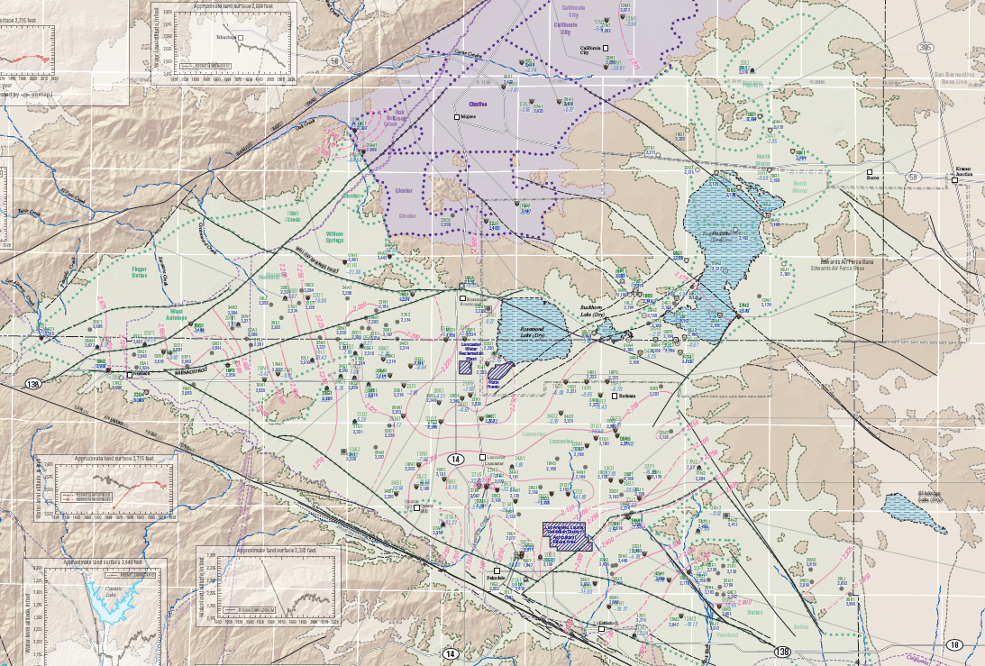
Antelope Valley Water-Level Contours
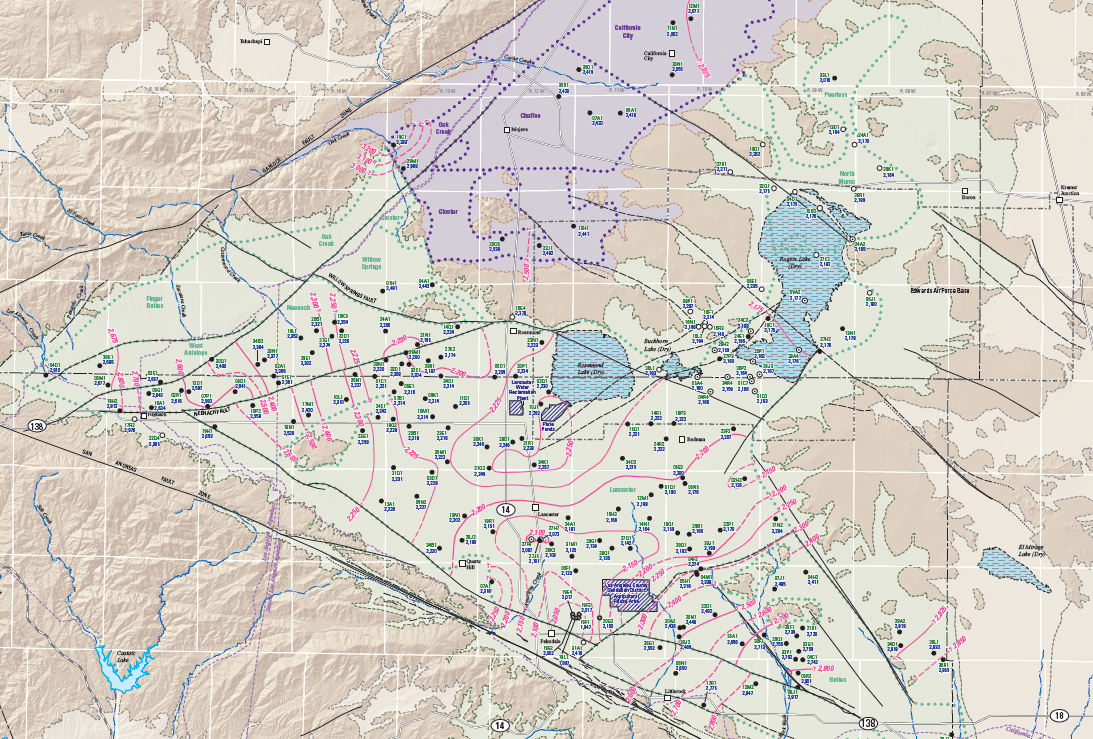
Antelope Valley Water-Level Changes