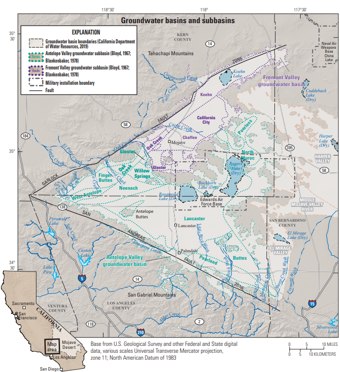
Water-Level Studies in the Antelope Valley and Fremont Valley Groundwater Basins
Antelope Valley Land Subsidence Study
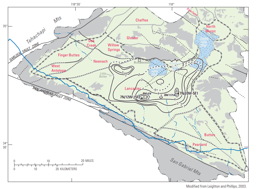
Land-subsidence contours in the Antelope Valley groundwater basin, California, as determined by measurements, interpolation, and extrapolation, 1930-92 (Siade and others, 2014, fig. 10). Names in red refer to groundwater subbasins.
Land subsidence resulting from groundwater-level declines has long been recognized as a problem in Antelope Valley, California. Water-level declines caused by groundwater development have eliminated the natural sources of discharge, and pumping for agricultural and urban uses have become the primary source of discharge from the groundwater system (Siade and others, 2014).
In 1988, the U.S. Geological Survey (USGS), in cooperation with the U.S. Air Force, began investigations of the effects of declining water levels and land subsidence at Edwards Air Force Base (EAFB) and possible mitigation measures, such as the injection of imported surface water into the ground-water system. At Edwards Air Force Base (EAFB), groundwater extractions have caused more than 150 feet of water-level decline, resulting in nearly 4 feet of subsidence (Ikehara and Phillips, 1994). Differential land subsidence has caused sinklike depressions and earth fissures and has accelerated erosion of the playa lakebed surface of Rogers Lake at EAFB (Blodgett and Williams, 1992), adversely affecting the runways on the lakebed which are used for landing aircraft such as the space shuttles. From 1990 to 1997, about 0.4 foot of aquifer-system compaction was measured at a deep (840 feet) borehole extensometer at EAFB (Sneed and Galloway, 2000). Annually, seasonal water-level fluctuations correspond to steplike variations in aquifer-system compaction; summer water-level drawdowns are associated with larger rates of compaction, and winter water-level recoveries are associated with smaller rates of compaction. The absence of aquifer-system expansion during recovery is consistent with the delayed drainage and resultant delayed, or residual, compaction of thick aquitards.
A numerical one-dimensional MODFLOW model of aquitard drainage was used to refine estimates of aquifer-system hydraulic parameters that control compaction and to predict potential future compaction at EAFB (Sneed and Galloway, 2000). Model results indicate that two thick aquitards account for most (greater than 99 percent) of the compaction measured during the period 1990-97. The results of three scenarios of future water-level changes indicate that these two thick aquitards account for most of the future compaction. The results also indicate that if water levels declined to about 30 feet below the 1997 water levels additional 1.7 feet of compaction may occur for the next 30 years, if water levels remained at 1997 levels that only 0.8 foot of compaction may occur during the same period, and even if water levels recovered to about 30 feet above 1997 water levels, another 0.5 foot of compaction may occur over the subsequent 30 years.
In 2007, the U.S. Geological Survey (USGS) entered into a cooperative agreement with the Los Angeles County Department of Public Works (LACDPW), Antelope Valley-East Kern Water Agency (AVEK), Palmdale Water District (PWD), and Edwards Air Force Base (EAFB) to (1) improve the understanding of the quantity, spatial distribution, and temporal distribution of natural recharge, urban recharge, and irrigation return flow and (2) incorporate this improved understanding into a groundwater-flow model that will help the agencies manage the Antelope Valley groundwater basin. The cooperative studies included data collection and analyses, numerical simulations of groundwater flow and land subsidence, and development of simulation-optimization models. The results of these studies indicated that redistribution of groundwater pumping and the injection of imported water may help to control land subsidence; however, land subsidence will continue in response to overdraft conditions (Siade and others, 2014).
Stakeholders
Antelope Valley State Water Contractors Association (AVSWCA)
Contacts
Project Chief:
Meghan Dick
Hydrologist
USGS California Water Science Center
4165 Spruance Rd. Ste 200
San Diego, CA 92101
Office: 619-225-6154
Maps
Antelope & Fremont Valleys: Detailed Basin Map
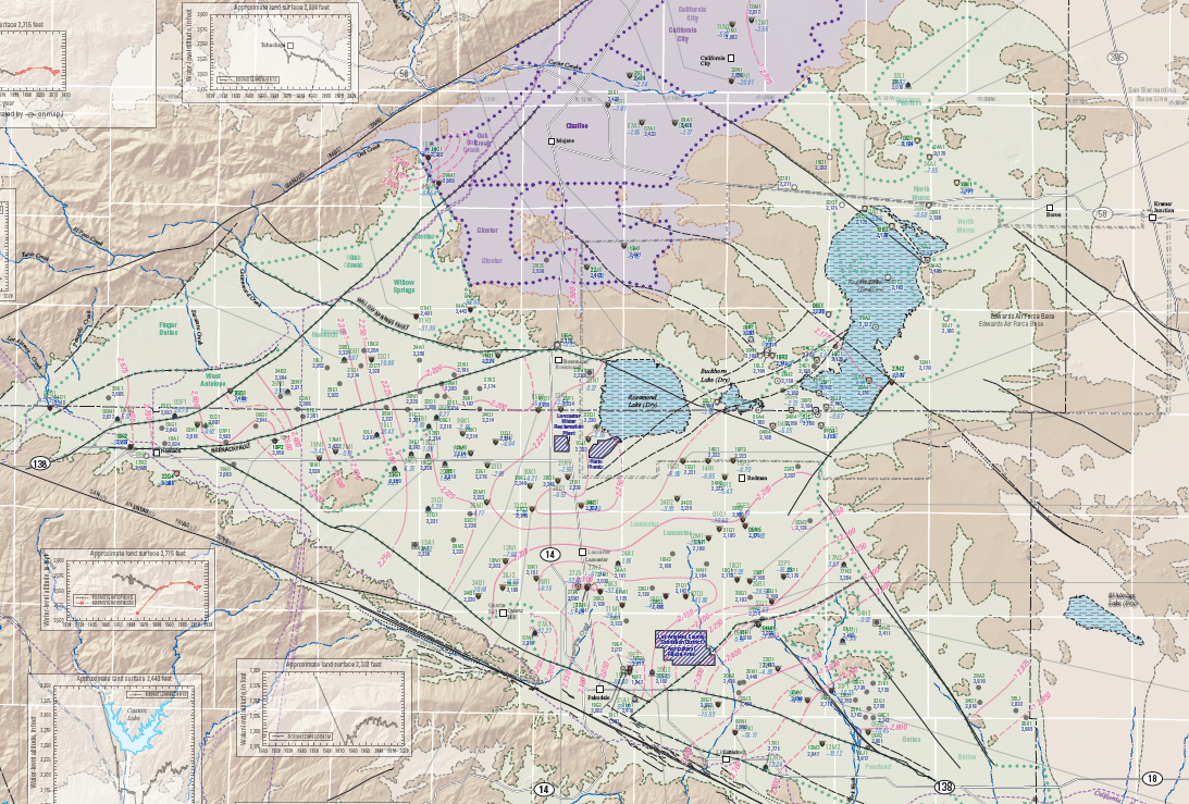
Antelope Valley Water-Level Contours
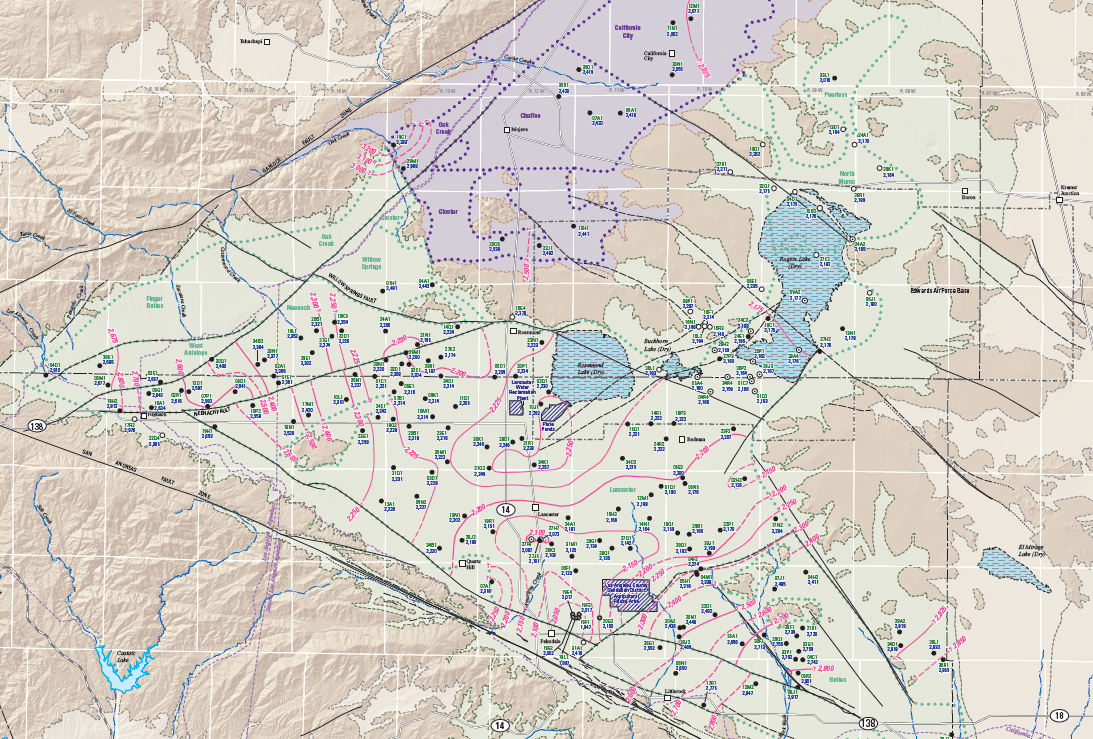
Antelope Valley Water-Level Changes