San Diego Hydrogeology
Illustrations and Maps
All maps and figures are provisional and subject to revision. (back to current maps)
Previous Proposed Report Figures

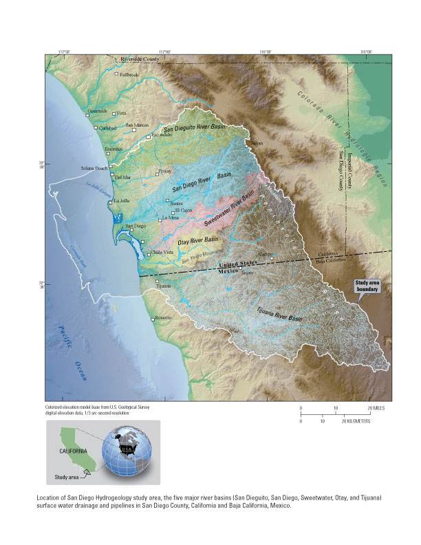
Study area
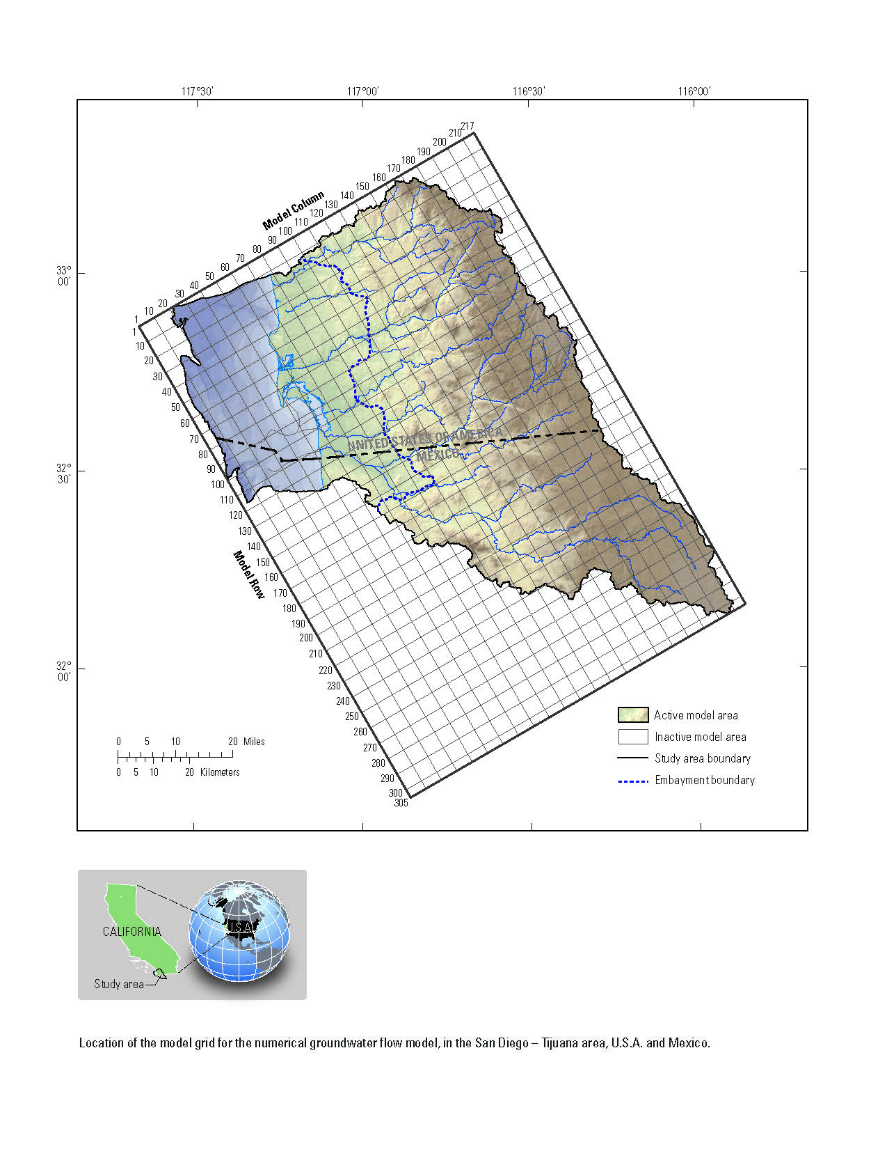
The study area is located within the San Diego sub-hydrologic region, which corresponds to the southern portion of the South Coast hydrologic region (California Department of Water Resources, 1967). The study area extends from the low-lying hills of the Laguna Mountians in the Peninsular Range which forms a drainage-basin divide with the Colorado River hydrologic region, to the western edge of the continential shelf beneath the Pacific Ocean. The northern boundary of the study area corresponds to the northern edge of San Dieguito River basin. The southern boundary of the study area corresponds to the southern edge of the Tijuana drainage basin in the Republic of Mexico. Generally, much of the the study area overlies a pull-apart structural basin formed by strike-slip faulting, with normal faulting on the lateral margins (Keller and Ward, 2001).
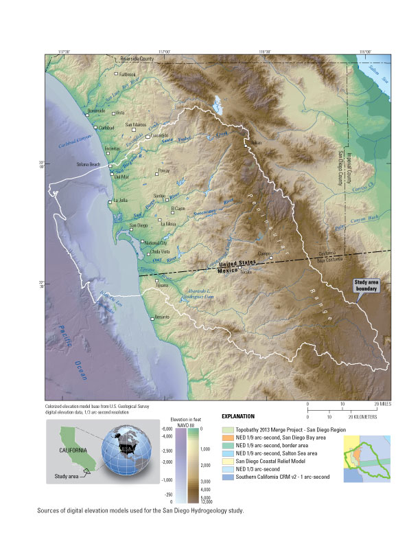
Elevation model
Multiple datasets were merged together to create a digital elevation model (DEM) to cover the entire study area. No single dataest covers the full study area in the ocean portion of the DEM so multiple dataset were needed.
To be certain the most detailed and accurate data available were used, datasets were compared, their metadata reviewed and a selection of the best datasets were used. These datasets, described below were merged giving precedence to the best and most detailed data
Surface hydrology
The NHD is a national framework for assigning reach addresses to water-related entities, such as industrial discharges, drinking water supplies, fish habitat areas, wild and scenic rivers. Reach addresses establish the locations of these entities relative to one another within the NHD surface water drainage network, much like addresses on streets. Once linked to the NHD by their reach addresses, the upstream/downstream relationships of these water-related entities--and any associated information about them--can be analyzed using software tools ranging from spreadsheets to geographic information systems (GIS). GIS can also be used to combine NHD-based network analysis with other data layers, such as soils, land use and population, to help understand and display their respective effects upon one another. Furthermore, because the NHD provides a nationally consistent framework for addressing and analysis, water-related information linked to reach addresses by one organization (national, state, local) can be shared with other organizations and easily integrated into many different types of applications to the benefit of all.
Dataset name: NHDH1807_931v220
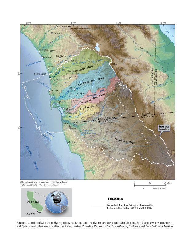
Watershed boundaries
This data set is a complete digital hydrologic unit boundary layer to the Subwatershed (12-digit) 6th level for the coterminous United States. This data set consists of geo-referenced digital data and associated attributes created in accordance with the "FGDC Proposal, Version 1.0 - Federal Standards For Delineation of Hydrologic Unit Boundaries 3/01/02"(http://www.ftw.nrcs.usda.gov/huc_data.html). Polygons are attributed with hydrologic unit codes for 4th level sub-basins, 5th level watersheds, 6th level subwatersheds, name, size, downstream hydrologic unit, type of watershed, non-contributing areas and flow modification. Arcs are attributed with the highest hydrologic unit code for each watershed, linesource and a metadata reference file.
The Watershed and Subwatershed hydrologic unit boundaries provide a uniquely identified and uniform method of subdividing large drainage areas. The smaller sized 6th level sub-watersheds (up to 40,000 acres) are useful for numerous application programs supported by a variety of local, State, and Federal Agencies. This data set is intended to be used as a tool for water-resource management and planning activities, particularly for site-specific and localized studies requiring a level of detail provided by large-scale map information. The dataset will be appended to a larger seamless nationally consistant geospatial database as other states complete their portion of the watershed boundary dataset.
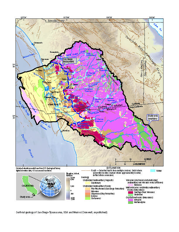
Geology
Geology used for the San Diego Hydrogeology study was merged from multiple datasets. Since the level of detail needed for this study is to develop a comprehensive understanding of the geology and hydrology focusing on the San Diego Formation and the overlying alluvial deposits and to use this understanding to evaluate expanded use of the alluvial deposits and the San Diego Formation for recharge and extraction, groupings were made to each of the datasets before merging them into one dataset.
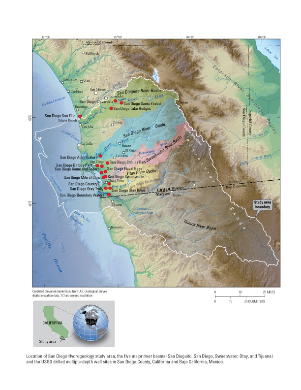
USGS-drilled multiple-depth wells
Multiple-depth well monitoring sites were constructed by the U.S. Geological Survey Research Drilling Unit for this study using a mud-rotary rig and wire-line coring techniques. The locations of the sites were chosen to map the geology, define hydrologic interactions, and monitor water-management issues in the study area. Prior to the construction of the USGS multiple-depth well monitoring sites, a USGS multiple-depth well monitoring site was constructed, in cooperation with the International Boundary and Water Commission, within the Tijuana River Valley in 1995 and is included as part of this study.
Dynamic Maps
Project Chief: Wes Danskin
Phone: 619-225-6132
Email: wdanskin@usgs.gov
Welcome to the United States Geological Survey (USGS) San Diego Hydrogeology (SDH) project website, which provides geologic and hydrologic information for the transboundary San Diego–Tijuana area, USA and Mexico. This website provides background information about the project; a variety of news items; a large amount of data, in particular for USGS multiple-depth, monitoring-well sites; geologic and hydrologic models; and additional resources including photos, illustrations, and references.
Last updated: July 2023.
Some additional data may be available from the USGS database National Water Information System (NWIS).
Questions about San Diego Hydrogeology? Please contact Wes Danskin (email: wdanskin@usgs.gov or send a letter). 619.225.6132