San Diego Hydrogeology
Recent Activity
- Construction of the Next Deep USGS Monitoring Well to Begin in October, 2012 (9/24/2012)
- Construction of the next deep USGS monitoring well site begins Oct. 20, 2011 (10/17/2011)
- Installation of multiple-depth monitoring well (5/16/2011)
Past Activities
- Drilling for knowledge of huge regional aquifer -- Hydrologists measure the untapped potential: San Diego Union Tribune (11/29/2010)
- Presentation acceptance notice for the joint GSA Cordilleran Section/Pacific Section AAPG with the Western Regional SPE meeting - Mapping the San Diego Formation near Chula Vista, California (5/2010)
- USGS just began drilling another deep multiple-depth monitoring well (2/2010)
- USGS stream monitoring during storms (1/2010)
- USGS provides easy access to data through maps (3/2008)
New Data
Recent USGS Reports
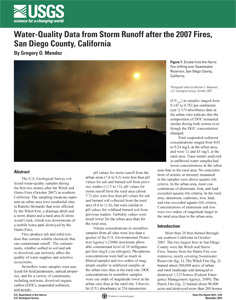
- Water-Quality Data from Storm Runoff after the 2007 Fires, San Diego County, California - view open-file report
- Installation of multiple-depth monitoring wells in Otay River Valley, Hydrologic investigations of the San Diego area, California - view fact sheet (PDF)
- Determining Age and Vertical Contribution of Ground Water Pumped from Wells in a Small Coastal River Basin. A Case Study in the Sweetwater River Valley, San Diego County, California - view USGS Open File Report released (2005)
Part or all of this page is linked to a Portable Document Format (PDF); the latest version of Adobe Reader or similar software is required to view it. Download the latest version of Adobe Reader, free of charge.
Project Chief: Wes Danskin
Phone: 619-225-6132
Email: wdanskin@usgs.gov
Welcome to the United States Geological Survey (USGS) San Diego Hydrogeology (SDH) project website, which provides geologic and hydrologic information for the transboundary San Diego–Tijuana area, USA and Mexico. This website provides background information about the project; a variety of news items; a large amount of data, in particular for USGS multiple-depth, monitoring-well sites; geologic and hydrologic models; and additional resources including photos, illustrations, and references.
Last updated: July 2023.
Some additional data may be available from the USGS database National Water Information System (NWIS).
Questions about San Diego Hydrogeology? Please contact Wes Danskin (email: wdanskin@usgs.gov or send a letter). 619.225.6132