San Diego Hydrogeology
Maps and Illustrations
All maps and illustrations are provisional and subject to revision. (archived versions: 2008, 2014, and 2017)
Maps with datasets:
- Study area
- Watersheds
- Digital Elevation Model (DEM)
- Streams
- Geologic Map
- USGS-drilled multiple-depth wells
- All monitoring sites
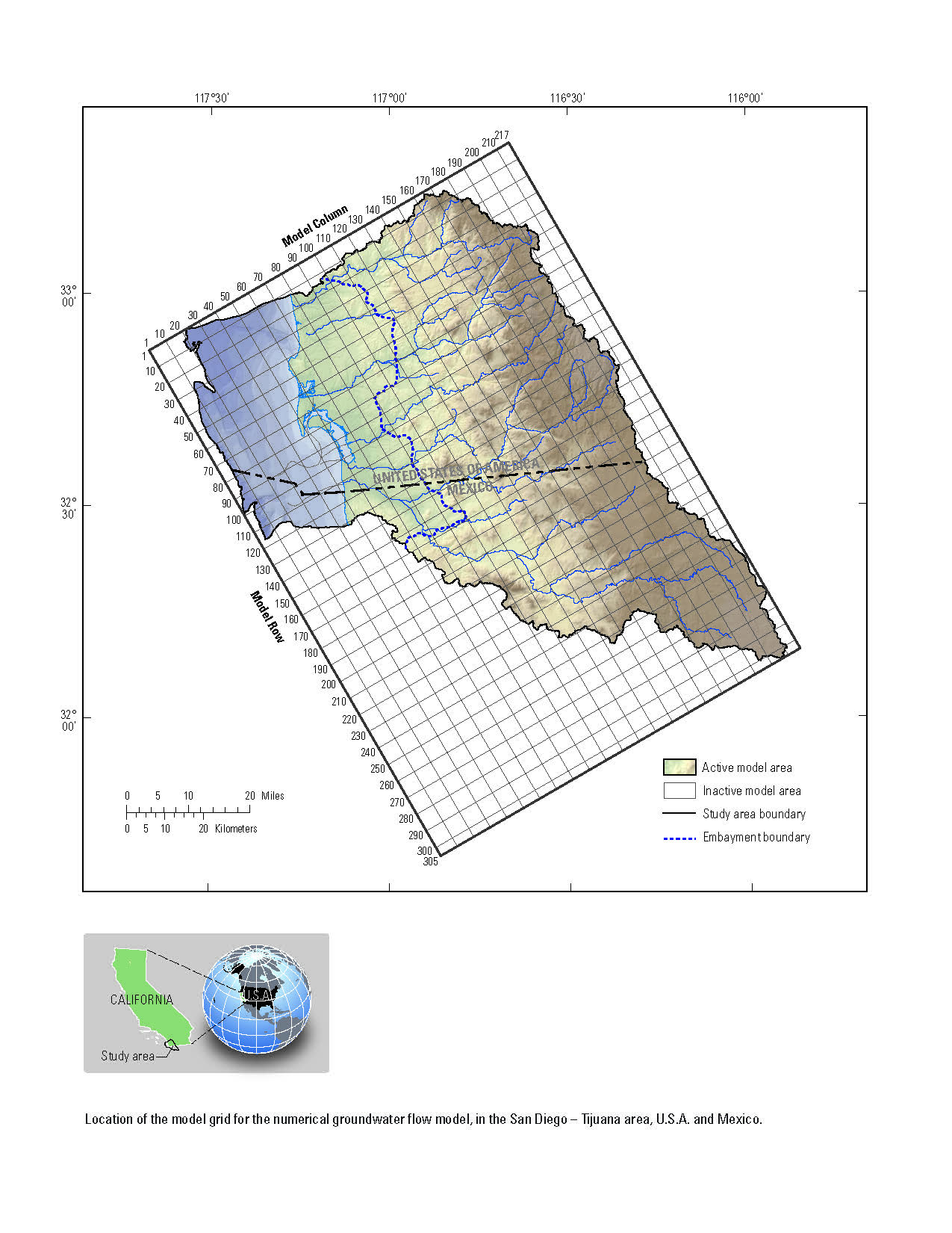
- Model boundary
Study area
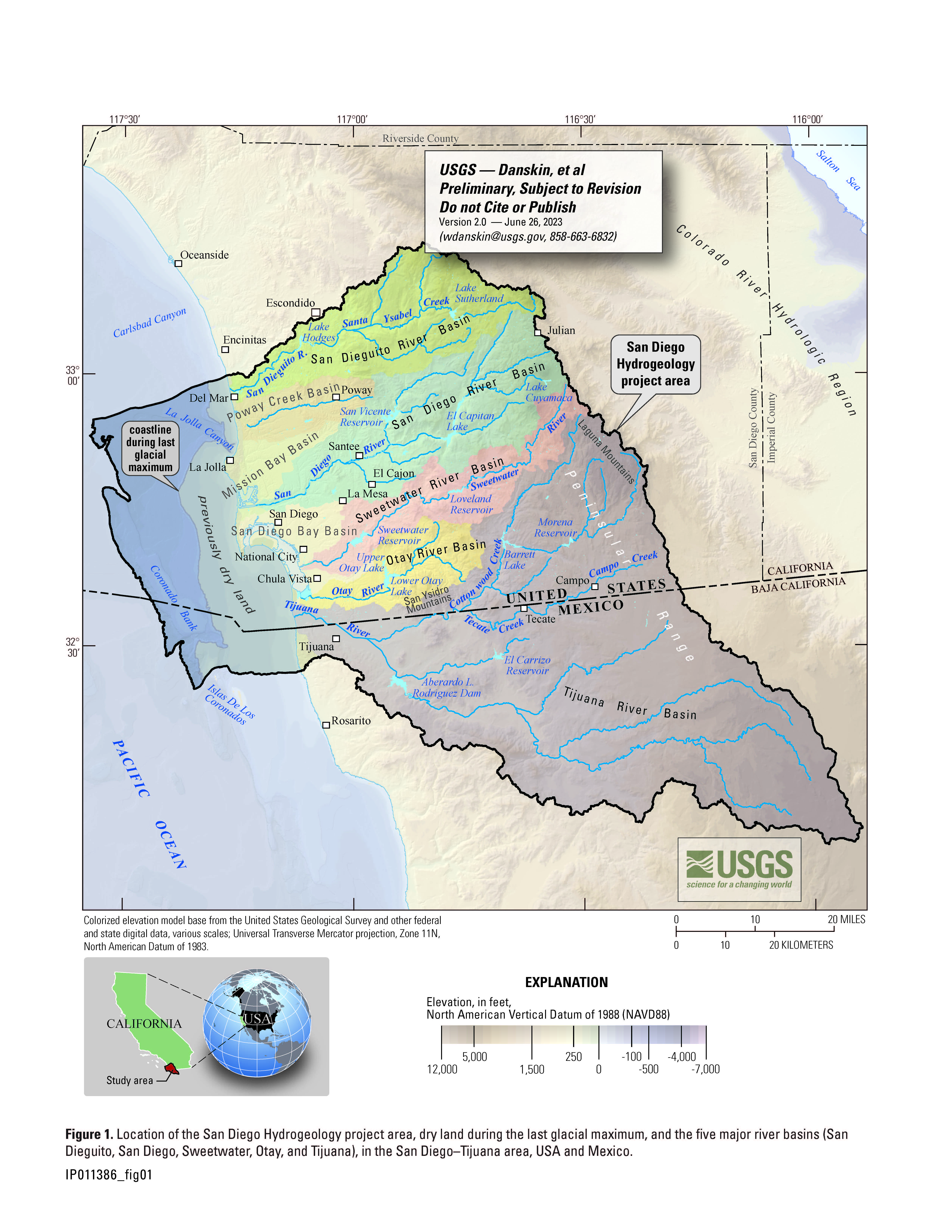
The San Diego Hydrogeology project study area is located within the San Diego sub-hydrologic region, which corresponds to the southern part of the South Coast hydrologic region (California Department of Water Resources, 1967). The study area extends from the crest of the Laguna Mountains in the Peninsular Range, which forms a drainage-basin divide with the Colorado River hydrologic region, to the western edge of the continental shelf beneath the Pacific Ocean. The northern boundary of the study area corresponds to the northern edge of the San Dieguito River Basin; the southern boundary of the study area corresponds to the southern edge of the Tijuana River Basin in Mexico.
Drainage areas
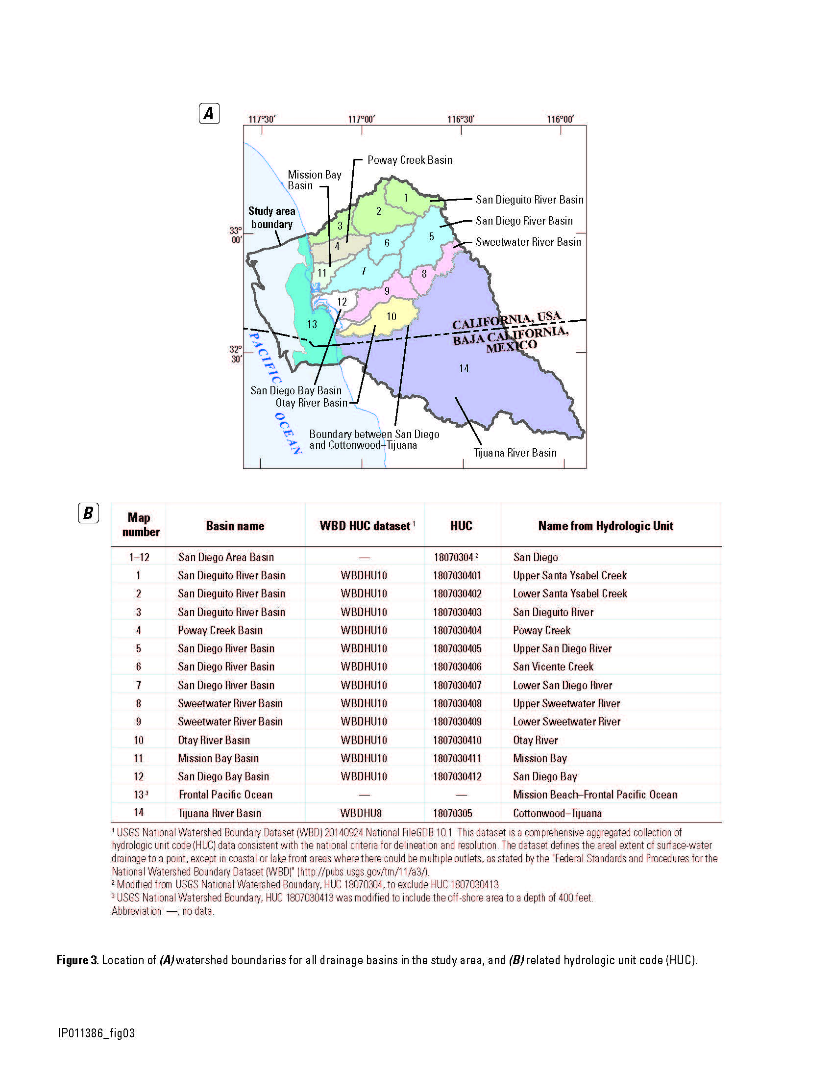
This illustration presents the Hydrologic Units Code (HUC) watershed boundaries, from the Watershed Boundary Dataset (WBD), that were used to create much of the San Diego Hydrogeology project study area. This figure is useful to replicate much of the land boundary for this study as explained fpr the study area. Hydrologic Unit Code boundaries used are available publicly.
Elevation model
Multiple datasets for both land-surface elevation and ocean bathymetry were merged to create a single digital elevation model (DEM) that extends over the entire study area. This DEM has been used extensively throughout the San Diego Hydrogeology project to display data, to create geologic and hydrologic models, and to create illustrations for reports. Prior to creating this DEM, no single dataset was available that extended over the entire study area. Some datasets had detailed data, but covered a relatively small area; some datasets had less resolution, but covered a larger area. To be certain that the most detailed and accurate data were used to create the study area DEM, many datasets were compared, the metadata for these datasets were reviewed, and then the best datasets were selected and combined.
Streams
A streams dataset was created to represent segments of potential flow for modeling purposes. Rivers and streams in the San Diego–Tijuana area are often dry much of the year. A streams dataset was created using the Elevation Model and the stream segments developed using the National Hydrography Database Plus High Resolution NHD PLUSHR to represent flow from equivalent surface areas. Using the flow accumulation from the Elevation Model, cells having at least 25 square kilometers flowing into them were identified. These identified cells were used to select segments from the numerous segments defined in the National Hydrography Database Plus High Resolution (NHD PLUSHR) dataset. These selected segments were copied to a new dataset representing the major streams. Attributes were added for future selection and display options. Complete details for these attributes are defined in the shapefile metadata.
Geology
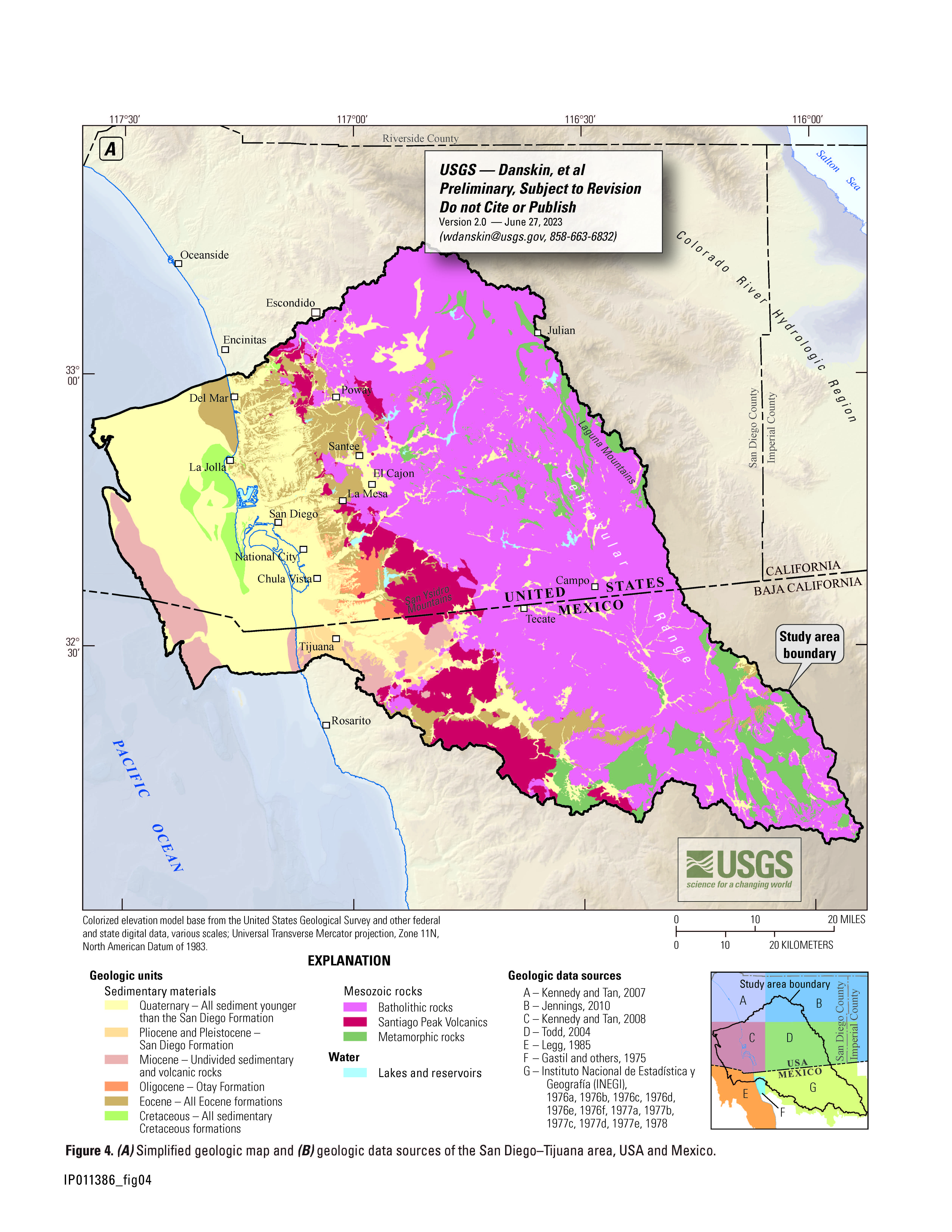
Geology used for the San Diego Hydrogeology study was merged from multiple datasets. This map integrates previously mapped geologic units throughout the study area from individual publications, into a unified geologic map that includes 9 geologic units and is seamless across the international border. This unified geologic map is useful in analyzing both geologic and hydrologic conditions.
USGS multiple-depth, monitoring-well sites
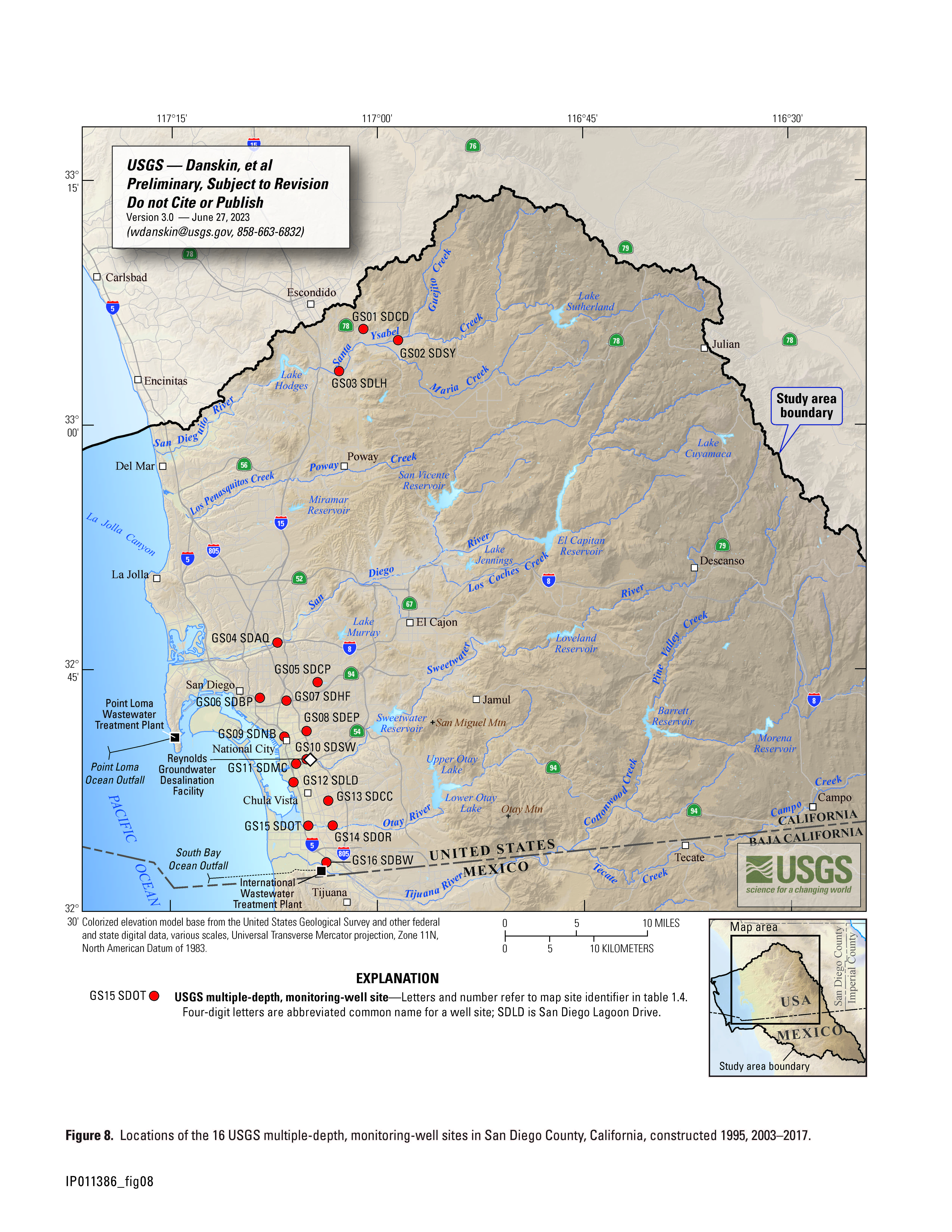
A total of 16 multiple-depth, monitoring-well sites were constructed by the USGS in San Diego County, California. Between June 2003 and March 2017, 15 of these sites were installed as part of the San Diego Hydrogeology project. A 16th site was constructed in 1995 as part of a previous USGS investigation; in 2005, this site was incorporated fully into the San Diego Hydrogeology project. All sites were constructed by the USGS Research Drilling Program using a mud-rotary drill rig and wire-line coring equipment. Each of the 16 sites had a borehole depth of as much as 2,658 feet below land surface and as many as 6 individual monitoring wells installed in the single borehole. These 16 sites have a total of 80 wells; information for each of these wells is provided under the data tab in USGS installed wells.
Sites
A dataset containing all sites used from 2001 to 2022 has been created using the latitude and longitude values of the sites. The quality of the location is dependent on the individual site. Complete information about the site and the data available is available through the National Water Information System (NWIS). An attribute for linking the USGS identifier to NWIS data has been included for each site. Included in this point shapefile dataset are 4 precipitation sites; 3 lake or reservoir sites; 59 stream sites; 6 spring sites; 80 USGS groundwater wells at the 16 USGS multiple-depth, monitoring well sites; and 216 non-USGS groundwater sites. A Microsoft® Excel® Workbook format file has been included in the compressed zip file with links to the National Water Information System. The San Diego Hydrogeology sites shapefile is presented for researchers to have the basic information for all sites presented with the necessary information to obtain data from USGS databases.
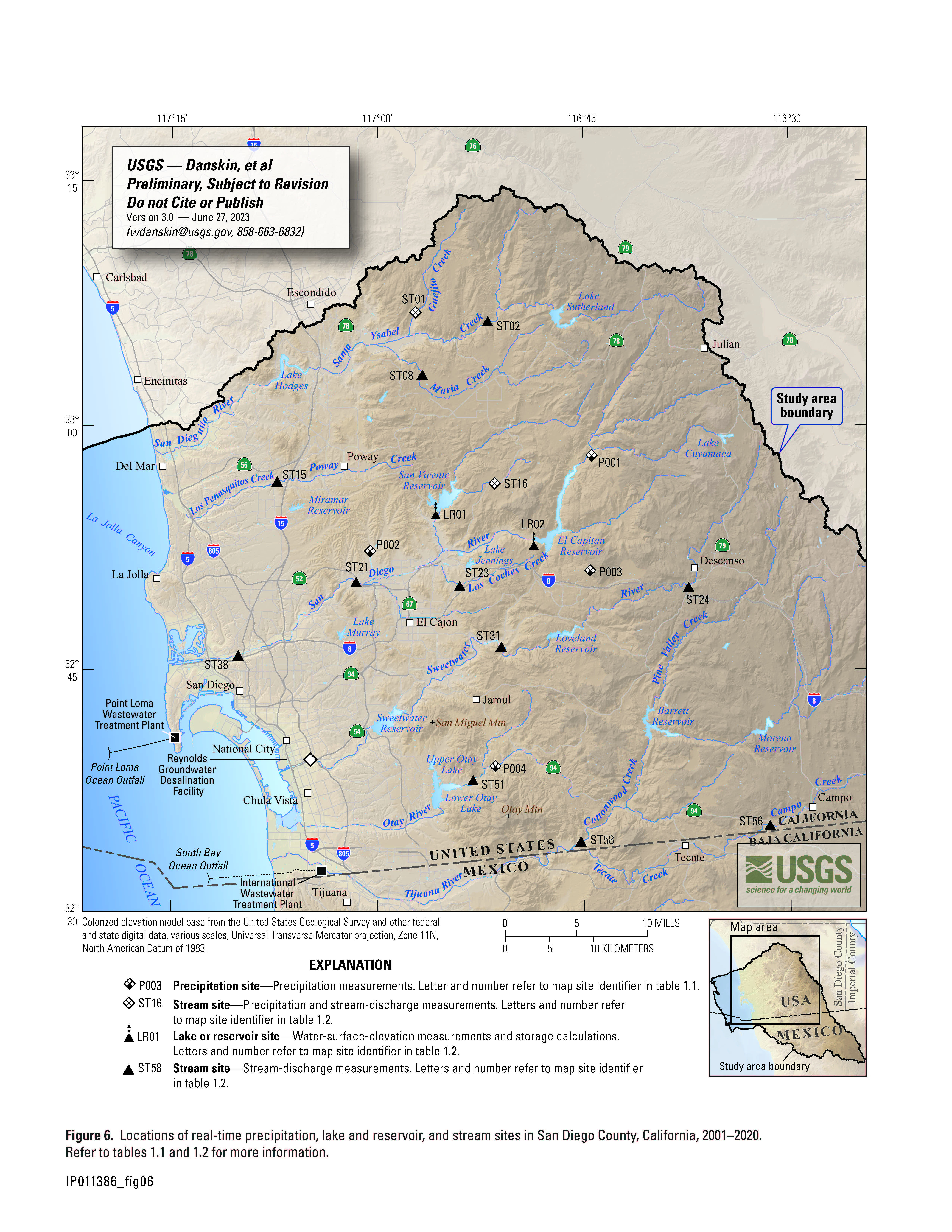
Real-time sites: Locations of real-time precipitation, lake and reservoir, and stream sites in San Diego County, California, 2001–2020.
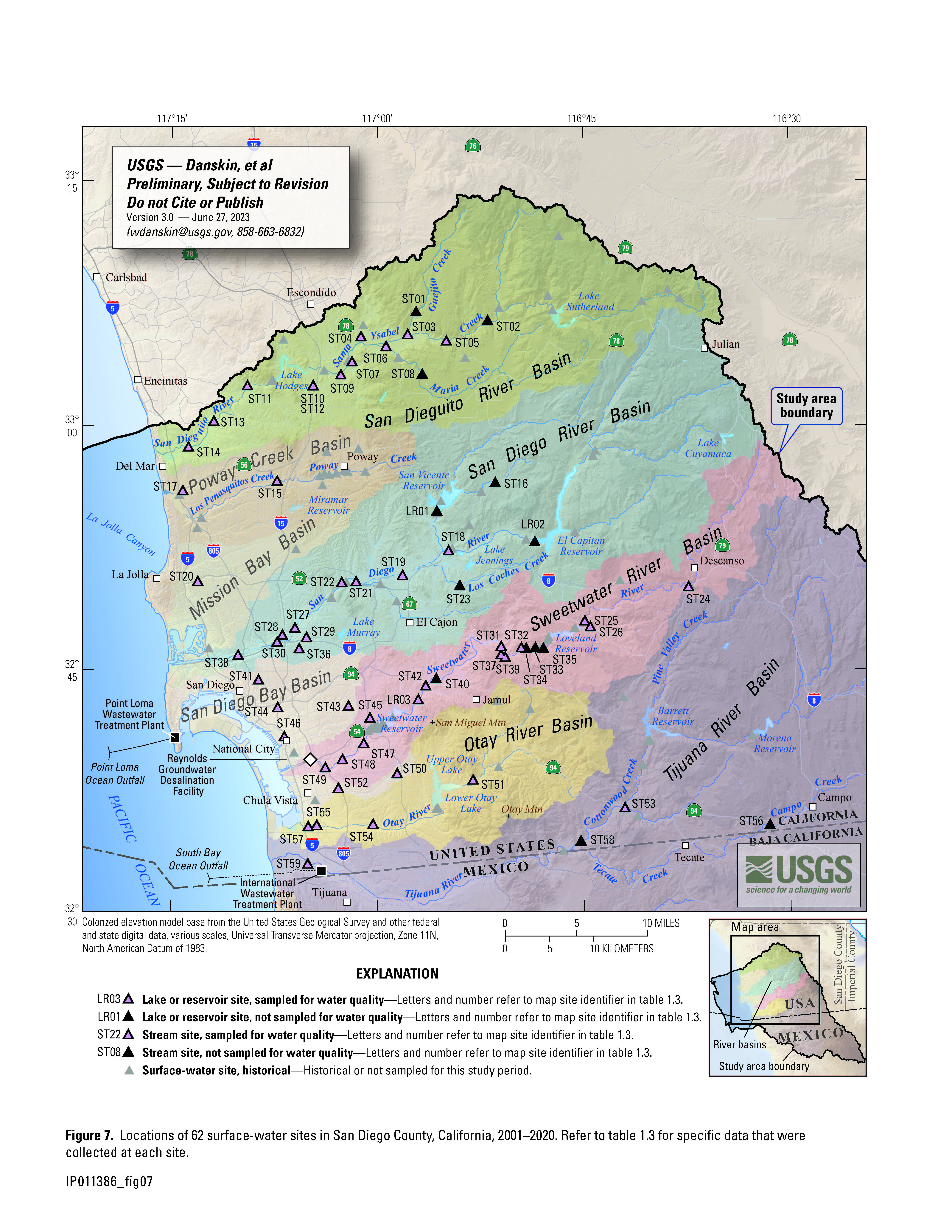
Surface-water sites: A variety of surface-water sites were monitored by the USGS in San Diego County, California, during the study period 2001–2020. These surface-water sites include 56 sites located along natural and concrete-lined streams and 3 sites located along earthen and concrete ditches; for simplicity, these 59 surface-water sites are referred to collectively as stream sites for this project. In addition, 3 surface-water sites are located at lakes, reservoirs, or impoundments, which are referred to collectively as lake or reservoir sites. In general, most surface-water bodies called lakes in the San Diego area also operate as reservoirs, hence the ambiguity of some geographic names.
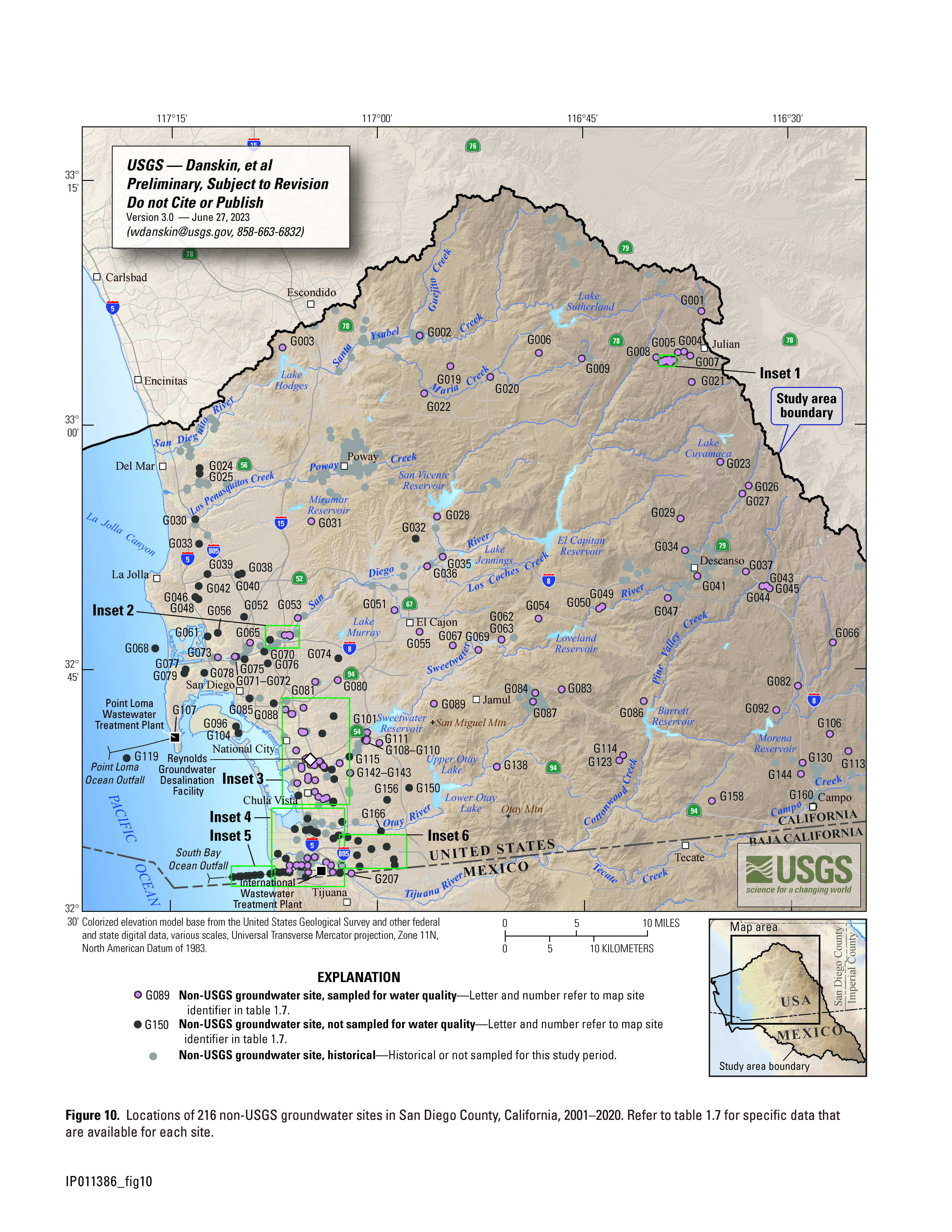
Non-USGS sites: A total of 216 other municipal and domestic supply wells, irrigation wells, monitoring wells, and boreholes were used to better define the geology and hydrology of the study area. These 216 wells and boreholes are referred to collectively as non-USGS groundwater sites in this report. Data from these non-USGS groundwater sites include lithologic data, paleontological samples, geophysical logs, groundwater levels, pumpage, and groundwater quality—although, in general, not all these types of data are available for each site.
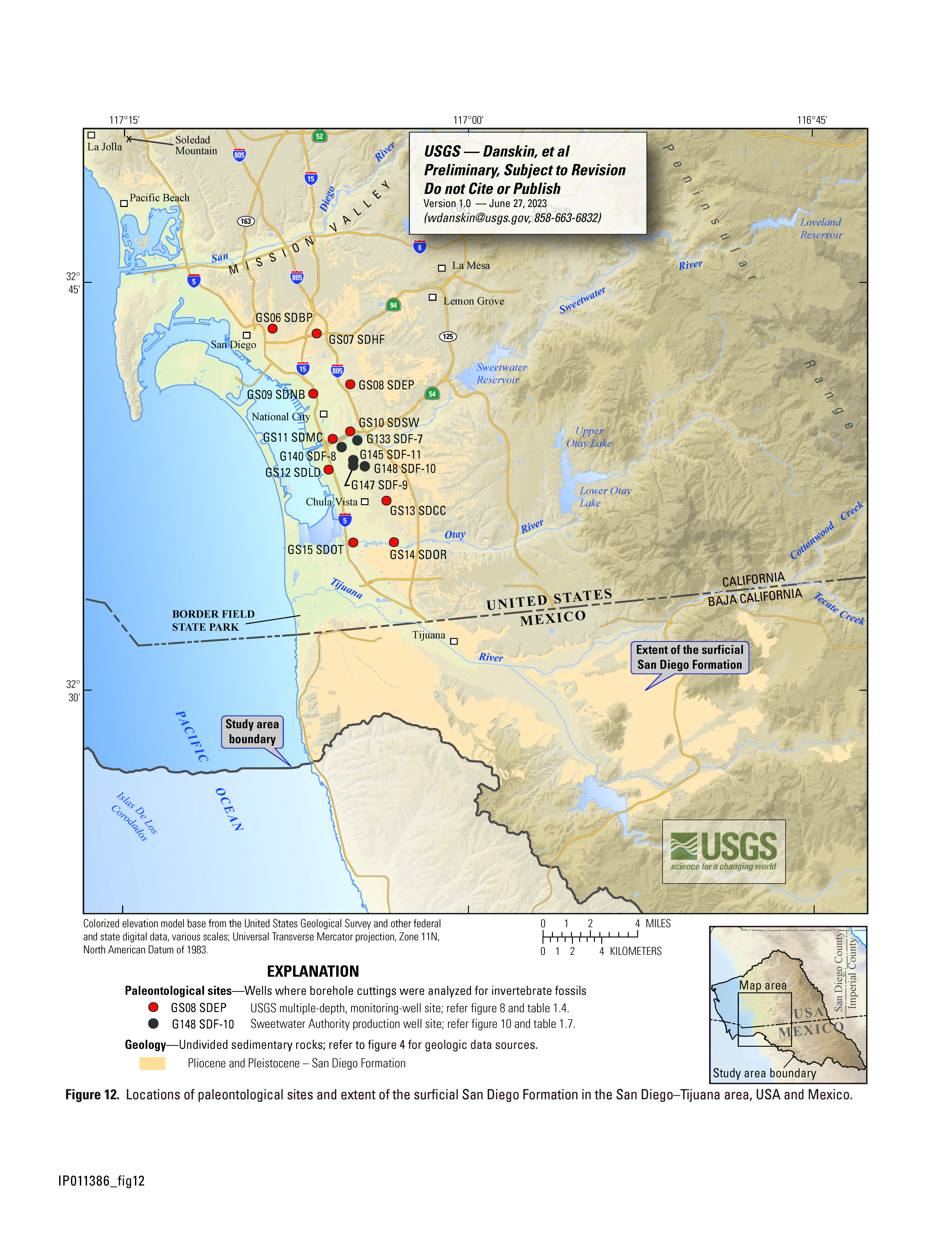
Paleontological sites: A total of 15 boreholes were used as paleontological sites for the USGS San Diego Hydrogeology project. These sites include 10 USGS multiple-depth, monitoring-well sites, and 5 non-USGS groundwater sites, which are recently-installed production wells (SDF-7–SDF-11) used for expansion of the Reynolds Groundwater Desalination Facility. Drill cuttings from each borehole were inspected for fossils. Despite the destructive nature of the drilling technique, many thousands of fossil shell fragments were found and identified. In particular, hundreds of Pliocene-age invertebrate species, mostly mollusks, were identified in the 15 boreholes.
Dynamic Maps
Project Chief: Wes Danskin
Phone: 619-225-6132
Email: wdanskin@usgs.gov
Welcome to the United States Geological Survey (USGS) San Diego Hydrogeology (SDH) project website, which provides geologic and hydrologic information for the transboundary San Diego–Tijuana area, USA and Mexico. This website provides background information about the project; a variety of news items; a large amount of data, in particular for USGS multiple-depth, monitoring-well sites; geologic and hydrologic models; and additional resources including photos, illustrations, and references.
Last updated: July 2023.
Some additional data may be available from the USGS database National Water Information System (NWIS).
Questions about San Diego Hydrogeology? Please contact Wes Danskin (email: wdanskin@usgs.gov or send a letter). 619.225.6132