Temecula Hydrogeology


USGS Installed Wells

Summary Table

Site characteristics Data available
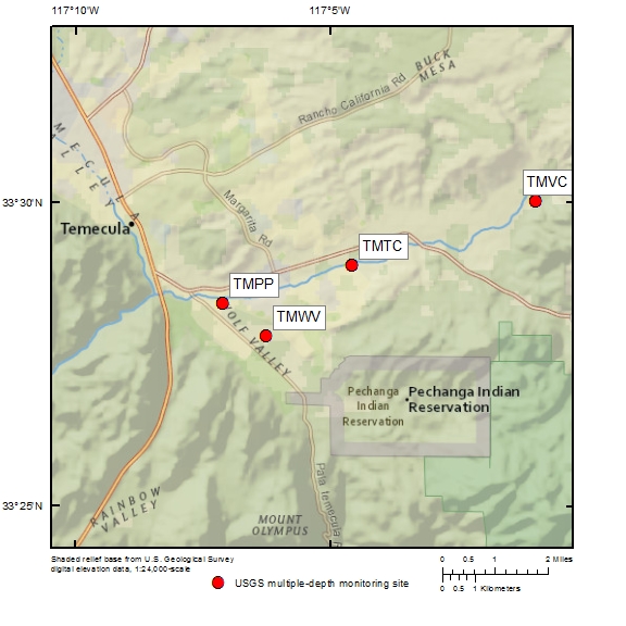
VDC Recharge Basin - TMVC (8S/1W-6R1-6)
Site Id: 333001117005701-6
Completion date: 8/31/2013
Basic characteristics:
description, photos, map, view cores, measure detail
Geophysical logs: view (PDF), raw data
.wcl = WellCAD files that require specialized software to view
.las = Century software that requires a free program to view
.pdf = requires Adobe Acrobat to view
Lithologic logs: summary, shaker, sieve, view shaker, view sieve
Nearby surface-water site: 11042510
940-960, 980-1020


Well Id


Hole
depth (ft)


Perforation
depth (ft)


Casing
size and type
8S/1W-
6R6
6R5
6R4
6R3
6R2
6R1

1033
1033
1033
1033
1033
1033

25-30
110-130
270-290
540-560
820-840

2" PVC
2" PVC
2" PVC
2" PVC
2" PVC
3" PVC
Groundwater levels
Well Id Real-time Daily & Field
7
dys
30
dys
90
dys
all
download
1
yr
2
yrs
5
yrs
all
 
all
download
8S/1W-
6R6
6R5
6R4
6R3
6R2
6R1
6R1-6


Water-quality
 
Well Id Parameters
 
All / Selected
8S/1W-
6R6
6R5
6R4
6R3
6R2
6R1
6R1-6


Temecula Creek - TMTC (8S/2W-15F1-5)
Site Id: 332857117043301-5
Completion date: 4/2/2013
Basic characteristics:
description, photos, map, view cores, measure detail
Geophysical logs: view (PDF), raw data
.wcl = WellCAD files that require specialized software to view
.las = Century software that requires a free program to view
.pdf = requires Adobe Acrobat to view
Lithologic logs: summary, shaker, sieve, view shaker, view sieve
Nearby surface-water site: none


Well Id


Hole
depth (ft)


Perforation
depth (ft)


Casing
size and type
8S/2W-
15F5
15F4
15F3
15F2
15F1

1720
1720
1720
1720
1720

80-100
240-260
610-630
1115-1135
1610-1650

2" PVC
2" PVC
2" PVC
2" PVC
3" PVC
Groundwater levels
Well Id Real-time Daily & Field
7
dys
30
dys
90
dys
all
download
1
yr
2
yrs
5
yrs
all
 
all
download
8S/2W-
15F5
15F4
15F3
15F2
15F1
15F1-5


Water-quality
 
Well Id Parameters
 
All / Selected
8S/2W-
15F5
15F4
15F3
15F2
15F1
15F1-5


Pala Park - TMPP (8S/2W-19A1-6)
Site Id: 332819117070601-6
Completion date: 9/30/2006
Basic characteristics:
description, photos, map, view cores, measure detail
Geophysical logs: view (PDF), raw data
.wcl = WellCAD files that require specialized software to view
.las = Century software that requires a free program to view
.pdf = requires Adobe Acrobat to view
Lithologic logs: summary, shaker, sieve, view shaker, view sieve
Nearby surface-water site: 11044000


Well Id


Hole
depth (ft)


Perforation
depth (ft)


Casing
size and type
8S/2W-
19A6
19A5
19A4
19A3
19A2
19A1

1499
1499
1499
1499
1499
1499

15-35
120-140
380-400
750-770
1110-1130
1430-1470

2" PVC
2" PVC
2" PVC
2" PVC
2" PVC
3" PVC
Groundwater levels
Well Id Real-time Daily & Field
7
dys
30
dys
90
dys
all
download
1
yr
2
yrs
5
yrs
all
 
all
download
8S/2W-
19A6
19A5
19A4
19A3
19A2
19A1
19A1-6


Water-quality
 
Well Id Parameters
 
All / Selected
8S/2W-
19A6
19A5
19A4
19A3
19A2
19A1
19A1-5


Wolf Valley - TMWV (8S/2W-20J1-2)
Site Id: 332747117061101-2
Completion date: 2/18/1990
Basic characteristics:
description, photos, map, view cores, measure detail
Geophysical logs: view (PDF), raw data
.wcl = WellCAD files that require specialized software to view
.las = Century software that requires a free program to view
.pdf = requires Adobe Acrobat to view
Lithologic logs: summary, shaker, sieve, view shaker, view sieve
Nearby surface-water site: 11042631


Well Id


Hole
depth (ft)


Perforation
depth (ft)


Casing
size and type
8S/2W-
20J2
20J1

590
590

160-180
555-575

2" PVC
2" PVC
Groundwater levels
Well Id Real-time Daily & Field
7
dys
30
dys
90
dys
all
download
1
yr
2
yrs
5
yrs
all
 
all
download
8S/2W-
20J2
20J1
20J1-2


Water-quality
 
Well Id Parameters
 
All / Selected
8S/2W-
20J2
20J1
20J1-2


Questions about Temecula Hydrogeology? Please contact Wes Danskin (email: wdanskin@usgs.gov or send a letter). 619.225.6132