Temecula Hydrogeology
USGS Data Map
Data Map Options
Please wait until a new map layer is displayed before turning on/off the next layer.
Click + to turn layer on.
Click - to turn layer off.
Click linked text for additional information.
Click on map icons for additional information about that site.
Note: Drawing time may vary with connection speed and browser and charts must be displayed from the USGS installed wells page.
Multiple-depth well sites
Groundwater sites
NWIS groundwater sites (well)
Surface-water
NWIS surface-water sites (estuary, lakes, streams, & spring)
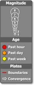
Recent Earthquakes
USGS earthquakes
Questions about Temecula Hydrogeology? Please contact Wes Danskin (email: wdanskin@usgs.gov or send a letter). 619.225.6132