
MODPATH Observation Process (MODPATH-OBS)
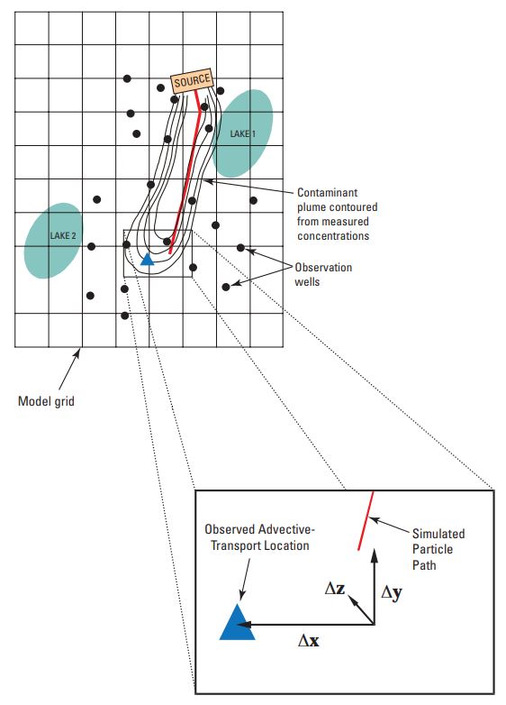
Conceptual representation of distance and direction observations. [The cells are 1,500-meter squares. Contours show boron concentrations of 400, 300, 200 and 100 micrograms per liter. The source concentration is poorly defined and probably changed over time, and the approximate nature of the source contributes to uncertainty of the observation. The blue triangle shows the approximated location of the advective front of the plume, and can be used as the observation location for a proximity observation. This point then becomes the reference point for the observation, with a distance of zero. The red line shows a simulated particle path. The end of the path is compared to the observation location, and the total distance between them, or component distances in any of the three axis directions, can be used as simulated values. Figure modified from Anderman and Hill, 2001.
The MODPATH-OBS (Hanson and others, 2013) computer program is designed to calculate simulated equivalents for observations related to advective groundwater transport that can be represented in a quantitative way by using simulated particle-tracking data. The simulated equivalents supported by MODPATH-OBS are
- distance from a source location at a defined time, or proximity to an observed location;
- time of travel from an initial location to defined locations, areas, or volumes of the simulated system;
- concentrations used to simulate groundwater age; and
- percentages of water derived from contributing source areas.
Although particle tracking only simulates the advective component of conservative transport, effects of non-conservative processes such as retardation can be approximated through manipulation of the effective-porosity value used to calculate velocity based on the properties of selected conservative tracers. This program can also account for simple decay or production, but it cannot account for diffusion. Dispersion can be represented through direct simulation of subsurface heterogeneity and the use of many particles.
MODPATH-OBS acts as a postprocessor to MODPATH, so that the sequence of model runs generally required is MODFLOW, MODPATH, and MODPATH-OBS. The version of MODFLOW and MODPATH that support the version of MODPATH-OBS presented here are MODFLOW-2005 or MODFLOW-LGR, and MODPATH-LGR. MODFLOW-LGR is derived from MODFLOW-2005, MODPATH 5, and MODPATH 6 and supports local grid refinement. MODPATH-LGR is derived from MODPATH 5. It supports the forward and backward tracking of particles through locally refined grids and provides the output needed for MODPATH_OBS. For a single grid and no observations, MODPATH-LGR results are equivalent to MODPATH 5. MODPATH-LGR and MODPATH-OBS simulations can use nearly all of the capabilities of MODFLOW-2005 and MODFLOW-LGR; for example, simulations may be steady-state, transient, or a combination. Though the program name MODPATH-OBS specifically refers to observations, the program also can be used to calculate model prediction of observations.
MODPATH-OBS is primarily intended for use with separate programs that conduct sensitivity analysis, data needs assessment, parameter estimation, and uncertainty analysis, such as UCODE_2005, and PEST.
In many circumstances, refined grids in selected parts of a model are important to simulated hydraulics, detailed inflows and outflows, or other system characteristics. MODFLOW-LGR and MODPATH-LGR support accurate local grid refinement in which both mass (flows) and energy (head) are conserved across the local grid boundary. MODPATH-OBS is designed to take advantage of these capabilities. For example, particles tracked between a pumping well and a nearby stream, which are simulated poorly if a river and well are located in a single large grid cell, can be simulated with improved accuracy using a locally refined grid in MODFLOW-LGR, MODPATH-LGR, and MODPATH-OBS. The locally-refined-grid approach can provide more accurate simulated equivalents to observed transport between the well and the river.
Program History
Version Highlights
Version Information and Notes
MODPATH-OBS v1.0.00 is the initial release.
- Release Notes [3 KB TXT]
- Readme File [13 KB TXT]
- Program Requirements [1 KB TXT]
Note: Users are encouraged to read the documents that are provided in the 'doc' directory of this software distribution.
Also see contents of the separate files: readme.txt, release.txt
Downloads and Documentation
General Information
Current Release: v.1.0.00, mm/dd/yyyy
If you wish to be included in our email list to be notified when updates occur, please send an email to xxx@usgs.gov.
Software Downloads
Users are highly encouraged to read through the documentation located in the "doc" folder. If you use of this software please cite the USGS Techniques and Methods 6-A42 Advective Transport Observations with MODPATH-OBS—Documentation of the MODPATH Observation Proces report in any associated publications and reports.
- Release Notes [3 KB TXT]
- Readme File [13 KB TXT]
- Program Requirements [1 KB TXT]
- mpath_obs_release.1_0.zip: Full distribution compressed with standard ZIP [92.3 MB]
Documentation of MODPATH-OBS
- Report: Advective Transport Observations with MODPATH-OBS—Documentation of the MODPATH Observation Process is the official USGS report that describes the theory and input instructions at the time the distribution was first released. If you use of this software please cite this report in any associated publications and reports.
The suggested citation is as follows:
Hanson, R.T., Kauffman, L.K., Hill, M.C., Dickinson, J.E., and Mehl, S.W., 2013, Advective transport observations with MODPATH-OBS—Documentation of the MODPATH observation process: U.S. Geological Survey Techniques and Methods book 6–chap. A42, 94 p.
- Online MODPATH-OBS User's Guide:
Packages and processes often evolve over time. The User's Guide includes the most up-to-date input instructions and related details.
Point of Contact
Support is provided for correcting bugs and clarification of how MODFLOW-OWHM is intended to work. Only limited assistance can be provided for MODPATH-OBS to specific problems.
Leon Kauffman
U.S. Geological Survey
New Jersey Water Science Center
3450 Princeton Pike
Lawrenceville, NJ 08648
lkauff@usgs.gov
MODPATH-OBS Email List for Updates
To be notified by the Integrated Hydrologic Model Development Team that supports MODPATH-OBS of updates/new versions, please send an email to lkauff@usgs.gov.
USGS Publications
Visit the USGS Publications Warehouse to search for reports by subject, author, date, USGS series or publication series number. Many of these reports will be available in .DJVU format. There is also information on obtaining printed copies of reports.
Visit the Water-Resources Reports page to browse for selected USGS Online Water-Resources reports. Most of these reports will be available in Adobe PDF or HTML format.
Disclaimers and Notices
Please refer to the USGS Water Resources Software User Rights Notice for complete use, copyright, and distribution information. This software has been approved for release by the U.S. Geological Survey (USGS). Although the software has been subjected to rigorous review, the USGS reserves the right to update the software as needed pursuant to further analysis and review. No warranty, expressed or implied, is made by the USGS or the U.S. Government as to the functionality of the software and related material nor shall the fact of release constitute any such warranty. Furthermore, the software is released on condition that neither the USGS nor the U.S. Government shall be held liable for any damages resulting from its authorized or unauthorized use.
Start here!
![[Image: Cover of software documentation report. ]](https://pubs.usgs.gov/tm/06/a42/images/cover.jpg "Go to MODPATH-OBS documentation report")
Advective Transport Observations with MODPATH-OBS—Documentation of the MODPATH Observation Process
U.S. Geological Survey Techniques and Methods
USGS Water Resources Software
The USGS develops water-resources software for use by the USGS in fulfilling its mission. Most of this software is available online for download at no charge.

Note: Some or all of this information is presented in Portable Document Format (PDF); the latest version of Adobe Reader or similar software is required to view it. Download the latest version of the free Adobe Reader from the Adobe web site. Visit http://www.adobe.com/accessibility/ for free tools that allow visually impaired users to read PDF files.
California Water Conditions
- Real-Time Data
- Streamflow Condidtiona
- WaterWatch
- USGS Data Mapper
- Groundwater
- Data
- Groundwater Watch
- Current Groundwater Conditions
- Surface Water
- Data
- Surface-Water Watch
- Runoff Estimates for California
- Water-Quality
- Data
- Watch
- Current Water Quality Conditions
- Historical Water Data for California
- Water Years 1961 through 2013
- USGS WaterNow
- Current-conditions directly to your mobile phone or email.