
New Methods to Measure Reservoir Storage Capacity and Sedimentation in Loch Lomond Reservoir
 A new method of measuring the storage capacity and sedimentation of Loch Lomond Reservoir, Santa Cruz shows promise to help water managers more effectively assess changes in water-storage capacity in similar basins with steep, narrow drainages in mountainous terrain. The method employs a combination of bathymetric scanning using multibeam-sidescan sonar, and topographic surveying using laser scanning. The techniques employed in the study help improve understanding of the quantitative effects of increased sedimentation rates on reservoir storage capacity. Understanding the resulting reductions in storage capacity can also help water managers more effectively adjust storage dynamically to prevent flooding.
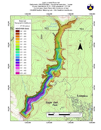
Full-basin topographic survey of Loch Lomond Reservoir using vessel-mounted topographic LIDAR and interferometric batheymetric sidescan sonar. Click on image for a larger view. |
Several methods have been used to monitor the storage capacity of, and the rate of sedimentation in, Loch Lomond Reservoir over the years of its operation since 1961. Each of these methods requires different equipment for data collection and different techniques for data processing, and therefore has a different accuracy level. In an effort to accurately define the storage capacity of the reservoir, the USGS examined each of these methods to determine the most accurate and cost-effective approach for performing bathymetric and topographic surveys of the reservoir bed. The report discusses each of these methods and its limitations, and describes the application of a new state-of-the-art method for combined bathymetric and topographic surveying to establish a new baseline for calculations of reservoir stage capacity. This study has been a cooperative effort between the USGS California Water Science Center and the City of Santa Cruz. The new report, "Analysis of Methods to Determine Storage Capacity of, and Sedimentation in, Loch Lomond Reservoir, Santa Cruz County, California, 2009" documents these advanced methods and can be found online at http://pubs.usgs.gov/sir/2011/5141/.
Project Chief: Kelly R. McPherson
Phone: 916-278-3169
Email: krmcpher@usgs.gov
Acknowledgements
![]() The authors thank Rikk Kvitek, director of the California State University, Monterey Bay, Seafloor Mapping Lab, for providing the equipment used for the 2009 survey. Dr. Kvitek, his staff, and students aided in the operation of the equipment, developed the methodology for the survey, and processed the 2009 altitude data. Their surveying expertise, quality-assurance verification, data processing, and documentation substantially shortened the time needed to complete this investigation.
The authors thank Rikk Kvitek, director of the California State University, Monterey Bay, Seafloor Mapping Lab, for providing the equipment used for the 2009 survey. Dr. Kvitek, his staff, and students aided in the operation of the equipment, developed the methodology for the survey, and processed the 2009 altitude data. Their surveying expertise, quality-assurance verification, data processing, and documentation substantially shortened the time needed to complete this investigation.
 The authors thank Chris Berry, Scot Lang, Matt Zeman, Terry Tompkins, members of the Loch Lomond Reservoir park staff, and support staff at the City of Santa Cruz, for providing easy access to the reservoir and the use of their boat for sediment sampling. All played an instrumental role and we could not have completed this integral study with out their help.
 The authors also thank the USGS sediment-sampling staff, who altered their schedules to accommodate the sampling at ideal lake conditions; the reviewers who provided their knowledge and expertise to enhance the quality of this report; and the editorial staff that makes our science clear and understandable to all.
Data Available
Loch Lomond Merged Bare Earth Topographic/Bathymetric XYZ File Sources
Topo: Riegle full resolution bare earth between waterline up to level of spillway retaining wall (LL_laser_UTM_HAE_BE.xyz)
Cleaning: All vegetation removed. All points below waterline and above top of spillway retaining wall removed.
Data file: (LL_laser_UTM_HAE_BE.xyz)
Processor: Steven Quan
SBET Control Station: SFML NetR5 on dam bench markBathymetry: Caris export of cleaned Swathplus data from 0.5m cube surface.
Data file: LochLomond_50cm_xyz.txt
Processor: Kate Thomas
UltraEdit: converted to positive z values by removing "-" sign
Data file: LochLomond_50cm_xy+z.tx
Processor: Rikk Kvitek
SBET Control Station: SFML NetR5 on dam bench mark
Merged topo & bathy
Processor: Rikk Kvitek
PFM: Combined 0.5 m Bathy & full resolution bare earth Topo files into 1m cube IHO Special Order
Data file: LL_TopoBthy50cmBE_UTM_HAE1m.pfm
Fledermaus: export 1m xyz topo/bathy bare earth
Data file: ExportTopoBathy1mcubeNAD83UTMHAE.xyz
Corpscon: converted topo/bathy NAD83 UTM HAE xyz to:Data files: 1m resolution
BE_TopoBathy1m_NAD83UTM_NAVD88m.csv
BE_TopoBathy1m_NAD83UTM_NGVD29ft.csv
BE_TopoBathy1m_NAD27_SP_NGVD29ft.csv
BE_TopoBathy1mcubeNAD83UTMHAE.xyzDate files: 0.5 m resolution
BE_TopoBathy50cm_NAD83UTMNAVD88
BE_TopoBathy50cm_NAD83UTMNGVD29ft
BE_TopoBathy50cm_NAD83UTMNGVD29ft
BE_TopoBathy50cm_NAD83UTMNGVD29m
TopoBathy50cmCUBE_xyz_HAEControl station bench mark solution
NGS OPUS solution for Static GPS data collect at dam BM March 29, 2009.
Geographic data
Sediment data
Link to data available on the National Water Inventory System (NWIS) database