By Steven K. Predmore, Kathryn M. Koczot, and Katherine S. Paybins
U.S. Geological Survey Open-File Report 96-629
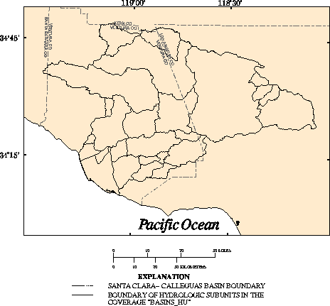
BASINS_HU

Description:        Hydrologic subunits.

Data type:          POLYGON.

Source:             Modified from:
                    (a) California Department of Water Resources, 1964, Names
                    and areal code numbers of hydrologic areas in the Southern
                    District: California Department of Water Resources, Office
                    Report, 57 p., pl. 4.

                    (b) United Water Conservation District, 1991a, Untitled:
                    Unpublished map delineating groundwater basins in the
                    United Water Conservation District: Ventura County, Calif.
                    (on file with United Water Conservation District).

                    (c)Greg Middleton, United Water Conservation District,
                    written commun., 1991.

Source scale:       (a) 1:260,00  (b) 1:100,000

Source projection:  (a) Unknown
                    (b) Base map from U.S. Geological Survey 30- x 60-minute
                        topographic quadrangles.

Method of entry:    Ground-water basin polygons were manually digitized from
                    paper source maps using an Altek Datatab AC40 digitizing
                    tablet, which has a resolution of 0.002 inch. The
                    geographic features and control points (points of known
                    coordinate locations) were digitized and transformed into
                    real-world coordinates.

Quality control:    The coverage was plotted and compared with the source maps.

Projection of data: Universal Transverse Mecator projection: Zone 11, Y-shift
                    -3.5 million meters.

Final update:       February 1994

Description
of variables:       BASINS_HU polygon attribute table.


Variable    Type       Length  Definition

BASIN       Character  4       California Department of Water Resources
                                 identification number.
NAME        Character  30      Name of hydrologic subunit.
BASIN_NAME  Character  20      Abbreviated name.
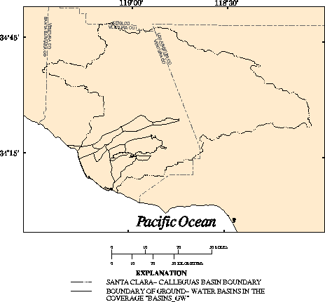
Description:        Selected ground-water basins.

Data type:          POLYGON.

Source:             Modified from:
                    (a) California Department of Water Resources, 1964, Names
                    and areal code numbers of hydrologic areas in the Southern
                    District: California Department of Water Resources, Office
                    Report, 57 p., pl. 4.

                    (b) California Department of Water Resources, 1975a,
                    Compilation of technical information for the Ventura County
                    cooperative investigation: California Department of Water
                    Resources, v. II, 234 p., pl. 2.

                    (c) United Water Conservation District, 1991a, Untitled:
                    Unpublished map delineating groundwater basins in the
                    United Water Conservation District: Ventura County, Calif.
                    (on file with United Water Conservation District).

                    (d) Greg Middleton, United Water Conservation District,
                    written commun., 1991.

Source scale:       (a) 1:260,000  (b) 1:126,720  (c) 1:100,000

Source projection:  (a) Unknown (b) Unknown (c) Base map from U.S.  Geological
                    Survey 30- x 60-minute topographic quadrangles.

Method of entry:    Ground-water basins polygons were manually digitized from
                    source maps using an Altek Datatab AC40 digitizing tablet,
                    which has a resolution of 0.002 inch. The geographic
                    features and control points (points of known coordinate
                    locations) were digitized and transformed into real-world
                    coordinates.

Quality control:    The coverage was plotted and compared with the source maps.

Projection of data: Universal Transverse Mecator projection: Zone 11, Y-shift
                    -3.5 million meters.

Final update:       July 6, 1994

Description
of variables:       BASINS_GW polygon attribute table.


Variable  Type        Length  Definition

NAME      Character   20      Name of ground-water basin.
BASIN_ID  Integer     3       Identification number.
ACRES     Floating    9       Acreage.
           decimal
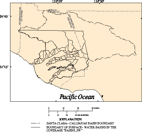
Description:        Surface-water basins.

Data type:          POLYGON.

Source:             Modified from:
                    (a) California Department of Water Resources, 1975a,
                    Compilation of technical information for the Ventura County
                    cooperative investigation: California Department of Water
                    Resources, v. II, 234 p., pl. 2.

                    (b) California Department of Water Resources, 1964, Names
                    and areal code numbers of hydrologic areas in the Southern
                    District: California Department of Water Resources, Office
                    Report, 57 p., pl. 4.

Source scale:       (a) 1:126,720  (b) 1:260,000

Source projection:  (a) Unknown  (b) Unknown.

Method of entry:    Surface-water basin polygons were manually digitized from
                    the paper source maps using an Altek Datatab AC40
                    digitizing tablet, which has a resolution of 0.002 inch.
                    The geographic features and control points (points of known
                    coordinate locations) were digitized and transformed into
                    real-world coordinates.

Quality control:    The coverage was plotted and compared with the source maps.

Projection of data: Universal Transverse Mecator projection: Zone 11, Y-shift
                    -3.5 million meters.

Final update:       June 15, 1993

Description
of variables:       BASINS_SW polygon attribute table.


Variable   Type       Length  Definition

NAME       Character  40      Name of surface-water basin from source (a).
SOURCE     Character  7       Modifications made to source (a) data.
ID_SOURCE  Character  4       Identification number from source (a).
GAGED?     Character  2       Identifies basin as gaged or ungaged.
BASIN_ID   Integer    3       Identification number.
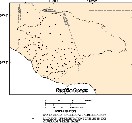
Description:        Location of selected precipitation stations.

Data type:          POINT.

Source:             Modified from:
                    County of Ventura Public Works Agency, 1990, Quadrennial
                    report of hydrologic data. 1985-1988: County of Ventura
                    Public Works Agency, variously paged.

Source scale:       Not applicable.

Source projection:  Geographic.

Method of entry:    Data were obtained in latitude-longitude coordinates,
                    converted to a coverage, and transformed to Universal
                    Transverse Mercator projection coordinates.

Quality control:    The coverage was verified with other information when
                    possible but was generally assumed to be without error.

Projection of data: Universal Transverse Mecator projection: Zone 11, Y-shift
                    -3.5 million meters.

Final update:       February 1, 1994

Description
of variables:       PRECIP_GAGE point attribute table.


Variable   Type       Length  Definition

GAGEID     Integer    4       Gaging station numeric identification number.
LAT        Integer    6       Latitude in degrees, minutes, and seconds.
LONG       Integer    8       Longitude in degrees, minutes, and seconds.
ALT        Numeric    5       Land-surface elevation, in feet above sea level.
LOCALID    Character  8       Township, range, and section location of the station.
FIRSTYEAR  Integer    5       The first year the precipitation station was in
                                  operation.
STA.NAME   Character  40      Name of each precipitation station.
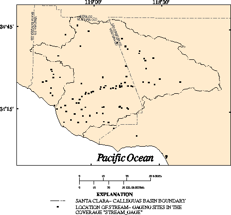
Description:        Selected U.S. Geological Survey and Ventura County
                    stream-gaging sites and miscellaneous measurement sites.

Data type:          POINT.

Source:             Modified from:
                    County of Ventura Public Works Agency, 1990, Quadrennial
                    report of hydrologic data. 1985-1988: County of Ventura
                    Public Works Agency, variously paged.

Source scale:       Not applicable.

Source projection:  Geographic.

Method of entry:    Data were obtained in latitude-longitude coordinates,
                    converted to a coverage, and transformed to Universal
                    Transverse Mercator coordinates.

Quality control:    The coverage was verified with other information when
                    possible but was generally assumed to be without error.

Projection of data: Universal Transverse Mecator projection: Zone 11, Y-shift
                    -3.5 million meters.

Final update:       February 1, 1994

Description
of variables:       STREAM_GAGE point attribute table.


Variable      Type       Length  Definition

GAGEID        Integer    15      Station number.
VCFCD_ID      Integer    3       Ventura County identification number.
LAT           Integer    7       Latitude in degrees, minutes, and seconds.
LONG          Integer    8       Longitude in degrees, minutes, and seconds.
ALT           Numeric    8       Land-surface elevation, in feet above sea level.
DATA_TYP      Character  1       Data collection instrumentation.
DATA_PER      Character  15      Frequency of data collection.
DATE          Character  9       Installation date.
GAGE_TYPE     Character  3       Recording device or method.
DRAIN_AREA    Numeric    8       Drainage basin area upstream from the gaging
                                    station.
STATION_NAME  Character  50      Descriptive station name, including stream name.
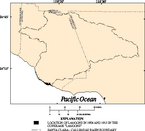
Description:        Selected lagoons in 1904 and 1915.

Data type:          POLYGON.

Source:             Modified from:
                    Weber, F.H., Kiessling, E.W., Sprotte, E.C., Johnson, J.A.,
                    Sherburne, R.W., and Cleveland, G.B., 1976, Seismic hazards
                    study of Ventura County, California: California Department
                    of Conservation, California Division of Mines and Geology
                    Open-FileReport 76-5, 396 p., pl. 3A.

Source scale:       1:48,000

Source projection:  Based on U.S. Geological Survey 7.5-minute topographic
                    quadrangles.

Method of entry:    Lagoon polygons were manually digitized from a mylar source
                    map using an Altek Datatab AC40 digitizing tablet, which
                    has a resolution of 0.002 inch. The geographic features and
                    control points (points of known coordinate locations) were
                    digitized and transformed into real-world coordinates.

Quality control:    The coverage was plotted and compared with the source map.

Projection of data: Universal Transverse Mecator projection: Zone 11, Y-shift
                    -3.5 million meters.

Final update:       April 2, 1992

Description
of variables:       No variables were added.


Variable  Type  Length  Definition

--        --    --      --
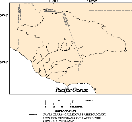
Description:        Selected streams and lakes.

Data type:          LINE.

Source:             Modified from:
                    U.S. Environmental Protection Agency, 1994, EPA reach file
                    version 3.0 Alpha Release (RF3-Alpha): U.S. Environmental
                    Protection Agency (Computer tape available from the U.S.
                    Environmental Protection Agency, 401 M Street SW (4503F),
                    Washington, DC 20460).

Source scale:       1:100,000

Source projection:  Geographic.

Method of entry:    Data were obtained in ARC/INFO interchange-file format and
                    imported into a coverage. Source digital data were provided
                    in latitude and longitude coordinates in decimal degrees.

Quality control:    The coverage was verified with other information when
                    possible but was generally assumed to be without error.

Projection of data: Universal Transverse Mecator projection: Zone 11, Y-shift
                    -3.5 million meters.

Final update:       October 6, 1992

Description
of variables:       STREAMS line attribute table.


Variable  Type       Length  Definition

NAME      Character  20      Stream name.