U.S. Geological Survey Open-File Report 96-629
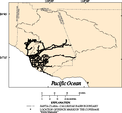
BENCHMARK

Description:        Location of selected bench marks.

Data type:          POINT.

Source:             Modified from:
                    Ventura County Department of Public Works, 1994a,
                    Benchmark transect data: Unpublished data on file with
                    Ventura County Surveying and Engineering Department.

Source scale:       Not applicable.

Source projection:  Geographic.

Method of entry:    Data were obtained in latitude-longitude
                    coordinates, converted to a coverage, and transformed to
                    UTM coordinates.

Quality control:    The coverage was verified with other
                    information when possible but was generally assumed to be
                    without error.

Projection of data: Universal Transverse Mecator projection:
                    Zone 11, Y-shift -3.5 million meters.

Final update:       September 29, 1994


Description
of variables:       BENCHMARK point attribute table.


Variable  Type       Length  Definition

PID       Character  17      Point identification number unique to each surveyed site
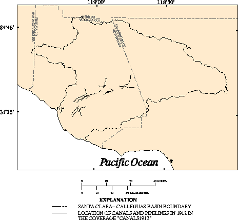
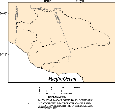
Description:        Selected fresh-water canals and pipelines, 1912.

Data type:          LINE.

Source:             Modified from:
         	    Adams, Frank, 1913, Irrigation resources of California and
	            their utilization: U.S.  Department of Agriculture, Office
	            of Experiment Stations Bulletin 254, 95 p., pl.  XVI.

Source scale:       1:70,400 (approximate)

Source projection:  Unknown.

Method of entry:    Canal lines were manually digitized from mylar source map
        	    using an Altek Datatab AC40 digitizing tablet, which has a
        	    resolution of 0.002 inch. The geographic features and
        	    control points (points of known coordinate locations) were
        	    digitized and transformed into real-world coordinates.

Quality control:    The coverage was plotted and compared with the source map.

Projection of data: Universal Transverse Mecator projection: Zone 11, Y-shift
	            -3.5 million meters.

Final update:       October 27, 1992

Description
of variables:       CANALS1912 line attribute table.


Variable        Type       Length  Definition

NAME            Character  30      Name of canal or pipeline from the source map.
CANALS_1912_ID  Integer    3       Identification number.
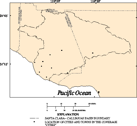
Description:         Locations of selected cities.

Data type:           POINT.

Source:              Modified from:
          	     U.S. Geological Survey 30- x 60-minute topographic
	             quadrangle maps.

Source scale:        1:100,000

Source projection:   Universal Transverse Mercator projection, zone 11.

Method of entry:     City points were manually digitized from paper source maps
	             using an Altek Datatab AC40 digitizing tablet, which has a
	             resolution of 0.002 inch. The geographic features and
	             control points (points of known coordinate locations) were
	             digitized and transformed into real-world coordinates.

Quality control:     The coverage was plotted and compared with the source maps.

Projection of data:  Universal Transverse Mecator projection: Zone 11, Y-shift
	             -3.5 million meters.

Final update:        June 15, 1992.

Description
of variables:        CITIES point attribute table.


Variable        Type             Length           Definition

NAME          Character          20               City name.
Description:        Location of selected
                    diversions, 1912.

Data type:          POINT.

Source:             Modified from:
                    Adams, Frank, 1913, Irrigation resources of California and
                    their utilization: U.S.Department of Agriculture, Office
                    of Experiment Stations Bulletin 254, 95 p., pl. XVI.

Source scale:       1:70,400 (approximate)

Source projection:  Unknown.

Method of entry:    Diversion location points were manually digitized from a
                    mylar source map using an Altek Datatab AC40 digitizing
                    tablet, which has a resolution of 0.002 inch. The
                    geographic features and control points (points of
                    known coordinat locations) were digitized and transformed
                    into real-world coordinates.

Quality control:    The coverage was plotted and compared with the source map.

Projection of data: Universal Transverse Mecator projection: Zone 11, Y-shift
                    -3.5 million meters.

Final update:       October 5, 1992.

Description
of variables:       DIVERSION1912 point attribute table.


Variable            Type          Length      Definition

RIVER               Character     19          Name of river at diversion location.
DIVERSION_NAME      Character     30          Name of source canal or pipeline.
CANAL/PIPELINE      Character     9           Identifies diversion structure as
                                              canal or pipeline.
DIVERSION_ID        Integer       3           Identification number.
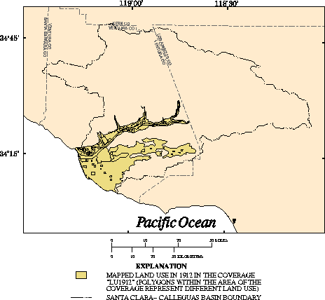
This section contains the land-use information for 1912, 1927, 1932, 1950, 1969, and 1988.
Description:        Selected land use in 1912.

Data type:          POLYGON.

Source:             Modified from:
                    Adams, Frank, 1913, Irrigation resources of California and
                    their utilization: U.S.  Department of Agriculture, Office
                    of Experiment Stations Bulletin 254, 95 p., pls. III and XVI.

Source scale:       1:70,400 (approximate)

Source projection:  Unknown.

Method of entry:    Land-use polygons were manually digitized from paper source
                    maps using an Altek Datatab AC40 digitizing tablet, which
                    has a resolution of 0.002 inch. The geographic features and
                    control points (points of known coordinate locations) were
                    digitized and transformed into real-world coordinates.

Quality control:    The coverage was plotted and compared with the source maps.

Projection of data: Universal Transverse Mecator projection: Zone 11, Y-shift
                    -3.5 million meters.

Final update:       November 30, 1993

Description
of variables:       LU1912 polygon attribute table.


Variable   Type             Length        Definition

ACRES      Floating          9            Acreage.
             decimal
NAME_1912  Character         20           Land-use classification.
IRR/DRY    Character         3            Identifies parcel as irrigated or dry farmed.
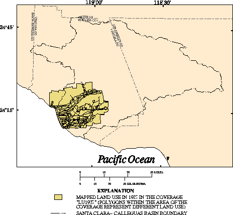
Description:        Selected land use in 1927.

Data type:          POLYGON.

Source:             Modified from:
                    (a) Whittier College, 1927, Untitled: Aerial photo mosaic
                    of west central Santa Clara - Calleguas Basin, Ventura
                    County, California: Fairchild Aerial Photography
                    Collection, Department of Geology, 1:43,200 (approximate),
                    1 sheet.

                    Supplementary data:

                    (b) Grunsky, C.E., 1925, Report on the water resources of
                    the Santa Clara River Valley: C.E. Grunsky Company,
                    Engineers, 100 p. (on file at U.S. Geological Survey, San
                    Diego, Calif.).

Source scale:       (a) 1:43,200 (approximate)
                    (b) Not applicable.

Source projection:  (a) Air photo mosaic, not rectified.
		    (b) Not applicable.

Method of entry:    Polygons were interpreted from a 1927 air photo mosaic
                    onto a mylar sheet. Land-use polygons were manually
                    digitized from the mylar map using an Altek Datatab AC40
                    digitizing tablet, which has a resolution of 0.002 inch.
                    The geographic features and control points (points of
                    known coordinate locations) were digitized and transformed
                    into real-world coordinates.

Quality control:    The coverage was plotted and compared with the source maps.

Projection of data: Universal Transverse Mecator projection: Zone 11, Y-shift
                    -3.5 million meters.

Final update:       June 17, 1992

Description
of variables:       LU1927 polygon attribute table.


Variable   Type            Length      Definition

ACRES      Floating        9           Acreage.
             decimal
NAME       Character       30          Land-use classification.
CODE_1927  Character       10          Abbreviated land-use classification.
IRR/DRY    Character       3           Identifies parcel as irrigated or dry farmed.
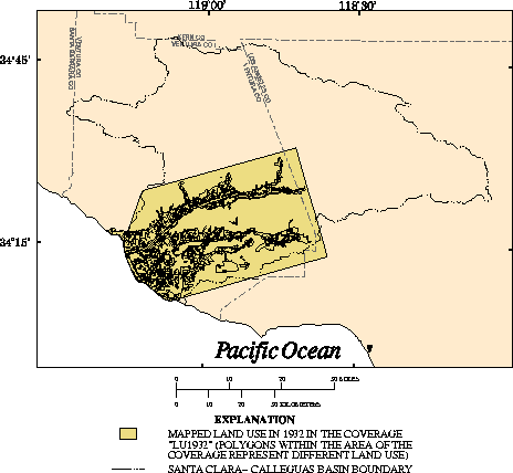
Description:        Selected land use in 1932.

Data type:          POLYGON.

Source:             Modified from:
                    California Department of Public Works, 1933, Ventura County
                    investigation: California Department of Public Works,
                    Division of Water Resources Bulletin No. 46, 244 p., pl. B

Source scale:       1:74,400 (approximate)

Source projection:  Unknown.

Method of entry:    Land-use polygons and control points (points of known
                    coordinate locations) were scanned from mylar source maps
                    with a Contex high resolution scanner and vectorized using
                    Cadcore software. The vectorized data were output in
                    DXF-file format, converted to a coverage, and transformed
                    into real-world coordinates.

Quality control:    The coverage was plotted and compared with the source maps.

Projection of data: Universal Transverse Mecator projection: Zone 11, Y-shift
                    -3.5 million meters.

Final update:       February 1, 1994

Description
of variables:       LU1932 polygon attribute table.


Variable      Type             Length    Definition

ACRES         Floating         9         Acreage.
               decimal
NAME          Character        30        Land-use classification.
CODE_1932     Character        10        Abbreviated land-use classification.
IRR/DRY       Character        3         Identifies parcel as irrigated or dry farmed.
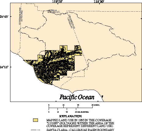
LU1950


Description:        Selected land use in 1950.

Data type:          POLYGON.

Source:             Modified from:
                    California Department of Public Works, 1950, Crop survey --
                    Ventura County surveyed 1949-50: Unpublished map series on
                    file with California Department of Public Works, Division
                    of Water Resources, Los Angeles Office.

Source scale:       1:15,960 (approximate)

Source projection:  Unknown.

Method of entry:    Land-use polygons and control points (points of known
                    coordinate locations) were scanned from mylar source maps
                    with a Contex high resolution scanner and vectorized using
                    Cadcore software. The vectorized data were output in
                    DXF-file format, converted to a coverage, and transformed
                    into real-world coordinates.

Quality control:    The coverage was plotted and compared with the
                    source maps.

Projection of data: Universal Transverse Mecator projection: Zone 11, Y-shift
                    -3.5 million meters.

Final update:       October 6, 1992

Description
of variables:       LU1950 polygon attribute table.

Variable        Type            Length    Definition

ACRES           Floating        9         Acreage.
                  decimal

NAME            Character       30        Land-use classification.

CODE_1950       Character       10        Abbreviated land-use classification.

MAP             Integer         3         Map-sheet number.

IRR/DRY         Character       3         Identifies parcel as irrigated or dry
                                          farmed.
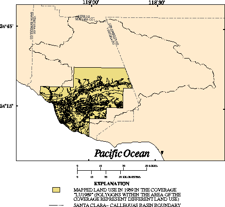
Description:        Selected land use in 1969.

Data type:          POLYGON.

Source:             Modified from:
                    California Department of Water Resources, 1970, Ventura
                    County land-use survey: 1969 Ventura County and upper Santa
                    Clara River drainage area land and water-use study:
                    California Department of Water Resources, Southern
                    District, Memorandum Report.

Source scale:       1:24,000

Source projection:  Polyconic.

Method of entry:    Land-use polygons and control points (points of known
                    coordinate locations) were scanned from mylar source maps
                    with a Contex high resolution scanner and vectorized using
                    Cadcore software. The vectorized data were output in
                    DXF-file format, converted to a coverage, and transformed
                    into real-world coordinates.

Quality control:    The coverage was plotted and compared with the
                    source maps.

Projection of data: Universal Transverse Mecator projection: Zone 11, Y-shift
                    -3.5 million meters.

Final update:       June 24, 1994

Description
of variables:       LU1969 polygon attribute table.

Variable   Type       Length  Definition

ACRES      Floating   9       Acreage.
             decimal
NAME       Character  30      Land-use classification.
CODE_1969  Character  10      Abbreviated land-use classification.
MAP        Character  5       Map-sheet number.
IRR/DRY    Character  3       Identifies parcel as irrigated or dry farmed.
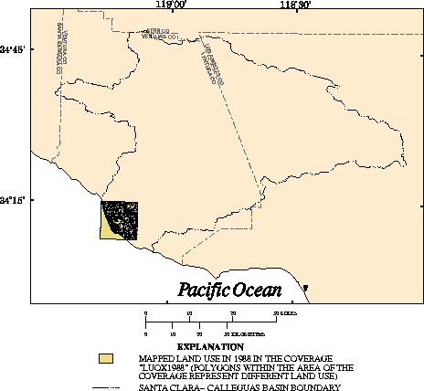
Description:        Selected land use in 1988 for the Oxnard quadrangle.

Data type:          POLYGON.

Source:             Modified from:
                    California Department of Water Resources, Southern
                    District, 1988, Ventura County and the Upper Santa Clara
                    River drainage area land-use survey, map 63-43 Oxnard,
                    Calif.: Unpublished map series on file with California
                    Department of Water Resources, Southern District.

Source scale:       1:24,000

Source projection:  Polyconic.

Method of entry:    Land-use polygons and control points (points of known
                    coordinate locations) were scanned from mylar source map
                    with a Contex high resolution scanner and vectorized using
                    Cadcore software. The vectorized data were output in
                    DXF-file format, converted to a coverage, and transformed
                    into real-world coordinates.

Quality control:    The coverage was plotted and compared with the source map.

Projection of data: Universal Transverse Mecator projection: Zone 11, Y-shift
                    -3.5 million meters.

Final update:       December 1, 1992

Description
of variables:       LUOX1988 polygon attribute table.

Variable   Type       Length  Definition

ACRES      Floating   9       Acreage.
             decimal
NAME       Character  30      Land-use classification.
CODE_1969  Character  10      Abbreviated land-use classification.
IRR/DRY    Character  3       Identifies parcel as irrigated or dry farmed.
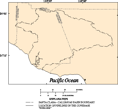
Description:        Selected pipelines within the United Water Conservation
                    District.

Data type:          LINE.

Source:             Modified from:
                    (a) United Water Conservation District, 1991b, Untitled:
                    Unpublished map representing all pipelines managed or
                    billed by United Water Conservation District: Ventura
                    County, Calif. (on file with the United Water Conservation
                    District).

                    (b) United Water Conservation District, 1989b, Pumping
                    Trough Pipeline Unit I and Unit II:  Unpublished schematic,
                    Y2-1895 7/21/89 (on file with the United Water Conservation
                    District, Ventura County, Calif.).

                    (c) United Water Conservation District, 1989a,
                    Oxnard-Hueneme Pipeline with Point Mugu Lateral and
                    Oceanview Pipeline: Unpublished schematic, OH-100-145
                    8/15/89 (on file with the United Water Conservation
                    District, Ventura County, Calif.).

Source scale:       (a) 1:62,500 (approximate)   (b) 1:12,000  (c) 1:12,000

Source projection:  (a) Unknown  (b) Unknown  (c) Unknown.

Method of entry:    Pipeline lines were manually digitized from paper and/or
                    mylar source maps using an Altek Datatab AC40 digitizing
                    tablet, which has a resolution of 0.002 inch. The
                    geographic features and control points (points of known
                    coordinate locations) were digitized and transformed into
                    real-world coordinates.

Quality control:    The coverage was plotted and compared with the source maps.

Projection of data: Universal Transverse Mecator projection: Zone 11, Y-shift
                    -3.5 million meters.
Final update:       January 15, 1993

Description
of variables:       PIPELINE line attribute table.

Variable     Type       Length  Definition

NAME         Character  30      Name of pipeline segments or spreading grounds.
PIPELINE_ID  Integer    3       Identification number.
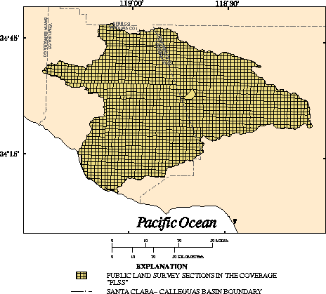
Description:        Public Land Survey System lines in Santa Clara-Calleguas
                    Basin.

Data type:          POLYGON.

Source:             Modified from:
                    Teale Data Center, 1989, Untitled: Digital data: Teal Data
                    Center, GIS Technology Center, Public Land Survey data,
                    Sacramento, Calif.

Source scale:       1:100,000

Source projection:  Universal Transverse Mercator projection, zone 11.

Method of entry:    Data were obtained in ARC/INFO interchange-file format and
                    imported into a coverage.

Quality control:    The coverage was verified with other information when
                    possible but was generally assumed to be without error.

Projection of data: Universal Transverse Mecator projection: Zone 11, Y-shift
                    -3.5 million meters.

Final update:       February 1994

Description
of variables:       PLSS polygon attribute table.

Variable  Type       Length  Definition

TOWN      Character  4       Township.
RANGE     Character  4       Range.
SECTION   Integer    2       Section.
MERIDIAN  Character  1       Meridian.
TRS       Character  10      Township, range, and section.
TR        Character  8       Township and range.
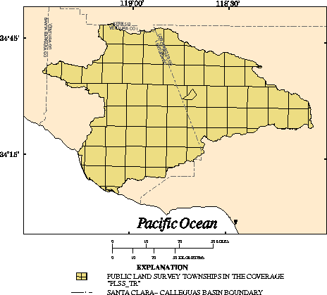
Description:        Township and range lines in Santa Clara-Calleguas Basin.

Data type:          POLYGON.

Source:             Modified from:
                    Teale Data Center, 1989, Untitled: Digital data: Teal Data
                    Center, GIS Technology Center, Public Land Survey data,
                    Sacramento, Calif.

Source scale:       1:100,000

Source projection:  Universal Transverse Mercator projection, zone 11.

Method of entry:    Section level digital data were acquired from Teale Data
                    Center. The sections were removed from the public land
                    survey to give the township and range polygons.

Quality control:    The coverage was plotted and compared with the
                    source maps.

Projection of data: Universal Transverse Mecator projection: Zone 11, Y-shift
                    -3.5 million meters.

Final update:       February 1994

Description
of variables:       PLSS_TR polygon attribute table.

Variable  Type       Length  Definition

TOWN      Character  4       Township.
RANGE     Character  4       Range.
TR        Character  8       Township and range.
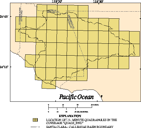
Description:        7.5-minute quadrangle boundaries.

Data type:          POLYGON.

Source:             U.S. Geological Survey 7.5-minute topographic quadrangle
                    maps.

Source scale:       1:24,000

Source projection:  Not applicable.

Method of entry:    Data were obtained in latitude-longitude coordinates,
                    converted to a coverage, and transformed to Universal
                    Transverse Mercator projection.

Quality control:    The coverage was verified with other information when
                    possible but was generally assumed to be without error.

Projection of data: Universal Transverse Mecator projection: Zone 11, Y-shift
                    -3.5 million meters.

Final update:       February 1994

Description
of variables:       QUADS_BND polygon attribute table.

Column     Type       Length  Definition

NAME_7.5   Character  50      U.S. Geological Survey 7.5-minute topographic
                                quadrangle name.
NAME_100K  Character  30      U.S. Geological Survey 30- x 60-minute topographic
                                quadrangle name.
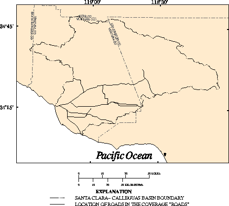
Description:        Selected roads.

Data type:          LINE.

Source:             Modified from:
                    U.S. Geological Survey 30- x 60-minute topographic
                    quadrangles.

Source scale:       1:100,000

Source projection:  Universal Transverse Mercator projection, zone 11.

Method of entry:    Road lines were manually digitized from paper source map
                    using an Altek Datatab AC40 digitizing tablet, which has a
                    resolution of 0.002 inch. The geographic features and
                    control points (points of known coordinate locations) were
                    digitized and transformed into real-world coordinates.

Quality control:    The coverage was plotted and compared with the source map.

Projection of data: Universal Transverse Mecator projection: Zone 11, Y-shift
                    -3.5 million meters.

Final update:       February 1, 1994

Description
of variables:      RASA_ROADS line attribute table.

Item  Type       Length  Definition

NAME  Character  30      Road name.
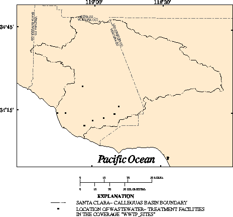
Description:        Discharge locations of selected wastewater-treatment
                    facilities.

Data type:          POINT.

Source:             Modified from:
                    Hanson, Randy, 1995, Untitled: Unpublished data base on
                    file with the U.S. Geological Survey, San Diego, Calif.

Source scale:       Not applicable.

Source projection:  Not applicable.

Method of entry:    Data were obtained in latitude-longitude coordinates,
                    converted to a coverage, and transformed to Universal
                    Transverse Mercator coordinates.

Quality control:    The coverage was verified with other information when
                    possible but was generally assumed to be without error.

Projection of data: Universal Transverse Mecator projection: Zone 11, Y-shift
                    -3.5 million meters.

Final update:       March 8, 1996

Description
of variables:       WWTP_SITES point attribute table.

Variable    Type       Length  Definition

LAT         Integer    6       Latitude in degrees, minutes, and seconds.
LONG        Integer    7       Longitude in degrees, minutes, and seconds.
STREAM      Character  30      Name of stream receiving wastewater.
DIS_AGENCY  Character  30      Wastewater discharging agency.
PER_RECORD  Character  10      Period of record, in years.
OUTFALL_ID  Integer    2       Identification number.