San Diego Hydrogeology
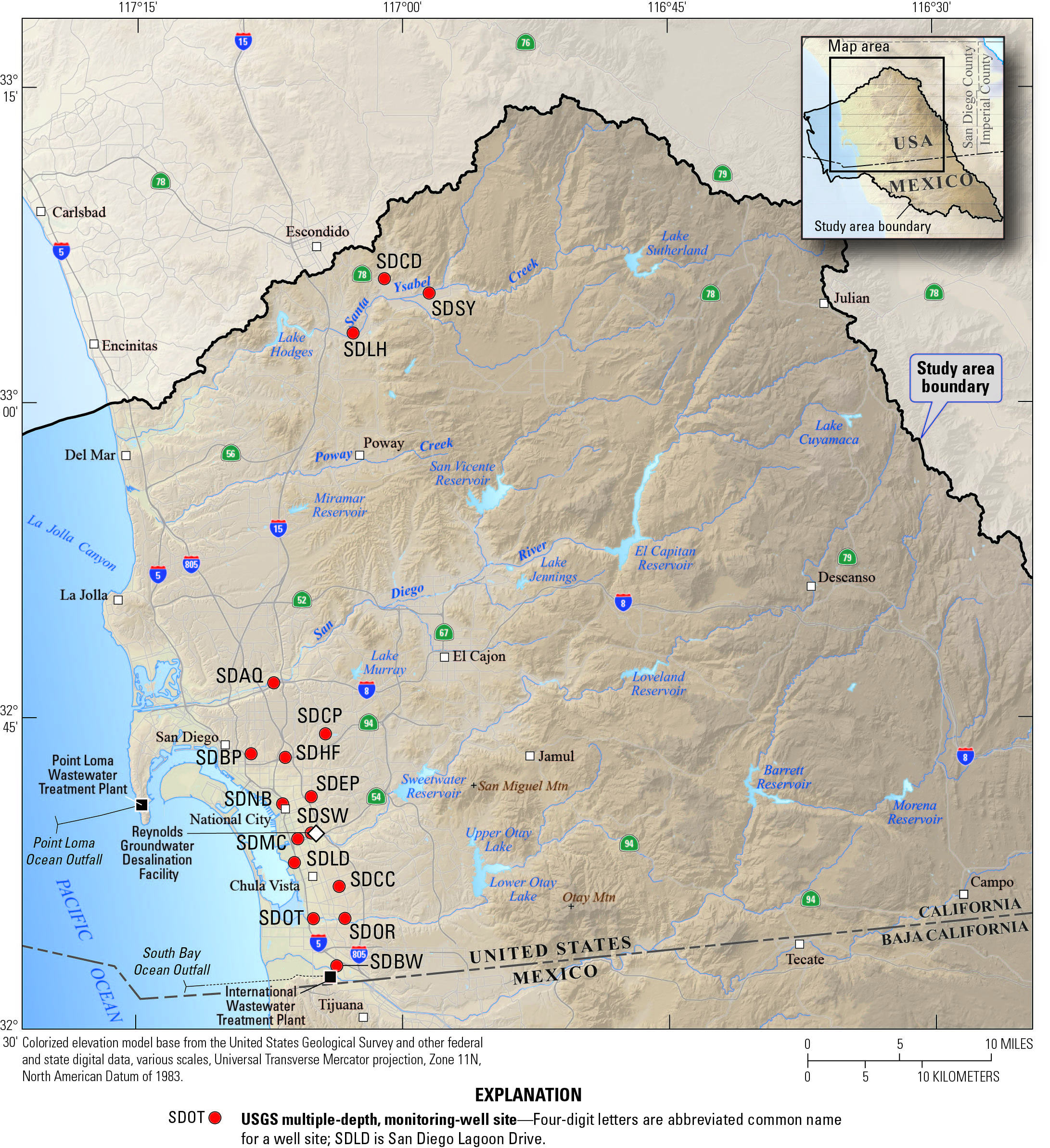
USGS Installed Wells
Well procedures, data accuracy, limitations, and summary table explanation
- USGS research drilling - Text explanation, Illustrative poster (7MB PDF), illustrative pages (2MB PDF)
- Groundwater technical procedures of the U.S. Geological Survey
- Data accuracy and limitations (from Groundwater technical procedures of the U.S. Geological Survey version 2010.1)
- Use of submersible pressure transducers in water-resources investigations - Summary of transducer accuracy
- Explanation of well site measurements accuracy for concrete-vaulted multiple-depth well sites in the study area
- Explanation of provisional water-level data
- Current and historical instantaneous data availability
- Explanation of basic data characteristics, terms and logs in summary table below
- Explanation of text/symbol colors in summary table below
- Text/bullet color blue indicates data are available.
Summary Table
Cloverdale - SDCD (12S/1W-30J3–5) - Site Id: 330555117010101–3
Site Characteristics
| Completion date: 2/1/2013 |
| Basic characteristics: description, photographs, map, view cores, measure detail |
| Geophysical logs: view well construction diagram, raw data .wcl = WellCAD files that require specialized software to view .las = Century Geophysical software that requires a free program to view .pdf = requires Acrobat Reader to view |
| Lithologic logs: summary, shaker, sieve, view shaker, view sieve |
| Nearby surface-water site: 330526117011101 |
| Well Id | Hole depth (ft) | Well depth (ft) | Perforation depth (ft) | Casing size & type |
|---|---|---|---|---|
| 12S/1W- 30J5 30J4 30J3 |
287.5 287.5 287.5 |
50 130 270 |
30–50 110–130 190–270* |
2" PVC 2" PVC 3" PVC |
| * Note: Perforation depths are not continuous. Depths are: 190–210; 250–270 |
||||
Data Available
Santa Ysabel - SDSY (12S/1W-34L2–5) - Site Id: 330514116582901–3, 330514116582801
Site Characteristics
| Completion date: 10/23/2010 |
| Basic characteristics: description, photographs, map, view cores, measure detail |
| Geophysical logs: view well construction diagram, raw data .wcl = WellCAD files that require specialized software to view .las = Century Geophysical software that requires a free program to view .pdf = requires Acrobat Reader to view |
| Lithologic logs: summary, shaker, sieve, view shaker, view sieve |
| Nearby surface-water site: 11027500 |
| Well Id | Hole depth (ft) | Well depth (ft) | Perforation depth (ft) | Casing size & type |
|---|---|---|---|---|
| 12S/1W- 34L5 34L4 34L3 34L2 |
60 355 355 355 |
60 90 210 340 |
50–60 70–90 190–210 280–340 |
2" PVC 2" PVC 2" PVC 2" PVC |
Data Available
Lake Hodges - SDLH (13S/2W-12M1–3) - Site Id: 330320117024701–3
Site Characteristics
| Completion date: 10/5/2012 |
| Basic characteristics: description, photographs, map, view cores, measure detail |
| Geophysical logs: view well construction diagram, raw data .wcl = WellCAD files that require specialized software to view .las = Century Geophysical software that requires a free program to view .pdf = requires Acrobat Reader to view |
| Lithologic logs: summary, shaker, sieve, view shaker, view sieve |
| Nearby surface-water site: 330353117015101 |
| Well Id | Hole depth (ft) | Well depth (ft) | Perforation depth (ft) | Casing size & type |
|---|---|---|---|---|
| 13S/2W- 12M3 12M2 12M1 |
280 280 280 |
50 110 270¹ |
30–50 90–110 170–250 |
2" PVC 2" PVC 2" PVC |
| ¹ Note: Sump | ||||
Data Available
San Elijo - SDSE (13S/4W-26Q1–3) - Site Id: 330031117154301–3
Site Characteristics
| Completion date: 11/17/2012 |
| Basic characteristics: description, photographs, map, view cores, measure detail |
| Geophysical logs: view well construction diagram, raw data .wcl = WellCAD files that require specialized software to view .las = Century Geophysical software that requires a free program to view .pdf = requires Acrobat Reader to view |
| Lithologic logs: summary, view shaker, view sieve |
| Nearby surface-water site: none |
| Well Id | Hole depth (ft) | Well depth (ft) | Perforation depth (ft) | Casing size & type |
|---|---|---|---|---|
| 13S/4W- 26Q3 26Q2 26Q1 |
1190 1190 1190 |
50 110 1120 |
40–50 100–110 300–1120* |
2" PVC 2" PVC 3" PVC |
| * Note: Perforation depths are not continuous. Depths are: 300–360, 380–580, 600–760, 780–1120 |
||||
Data Available
Aquaculture - SDAQ (16S/2W-18J3–7) - Site Id: 324641117071501–5
Site Characteristics
| Completion date: 11/22/2004 |
| Basic characteristics: description, photographs, map, view cores, measure detail |
| Geophysical logs: view well construction diagram, raw data .wcl = WellCAD files that require specialized software to view .las = Century Geophysical software that requires a free program to view .pdf = requires Acrobat Reader to view |
| Lithologic logs: summary, shaker, sieve, view shaker, view sieve |
| Nearby surface-water site: 324643117071601 |
| Well Id | Hole depth (ft) | Well depth (ft) | Perforation depth (ft) | Casing size & type |
|---|---|---|---|---|
| 16S/2W- 18J7 18J6 18J5 18J4 18J3 |
949.5 949.5 949.5 949.5 949.5 |
50 165 485 730 940 |
30–50 145–165 465–485 710–730 840–940* |
2" PVC 2" PVC 2" PVC 2" PVC 2" PVC |
| * Note: Perforation depths are not continuous. Depths are: 840–860; 880–900; 920–940 |
||||
Data Available
Chollas Park - SDCP (16S/2W-34G1–6) - Site Id: 324416117042001–6
Site Characteristics
| Completion date: 6/8/2011 |
| Basic characteristics: description, photographs, map, view cores, measure detail |
| Geophysical logs: view well construction diagram, raw data .wcl = WellCAD files that require specialized software to view .las = Century Geophysical software that requires a free program to view .pdf = requires Acrobat Reader to view |
| Lithologic logs: summary, shaker, sieve, view shaker, view sieve |
| Nearby surface-water site: none |
| Well Id | Hole depth (ft) | Well depth (ft) | Perforation depth (ft) | Casing size & type |
|---|---|---|---|---|
| 16S/2W- 34G6 34G5 34G4 34G3 34G2 34G1 |
1100 1100 1100 1100 1100 1100 |
50 160 350 540 780 1100¹ |
30–50 140–160 330–350 520–540 760–780 920–1060* |
2" PVC 2" PVC 2" PVC 2" PVC 2" PVC 3" PVC |
| * Note: Perforation depths are not continuous. Depths are: 920–940; 980–1000; 1040–1060 ¹ Note: Sump |
||||
Data Available
Balboa Park - SDBP (17S/3W-1K1–5) - Site Id: 324318117083101–5
Site Characteristics
| Completion date: 2/7/2008 |
| Basic characteristics: description, photographs, map, view cores, measure detail |
| Geophysical logs: view well construction diagram, raw data .wcl = WellCAD files that require specialized software to view .las = Century Geophysical software that requires a free program to view .pdf = requires Acrobat Reader to view |
| Lithologic logs: summary, shaker, sieve, view shaker, view sieve |
| Nearby surface-water site: none |
| Well Id | Hole depth (ft) | Well depth (ft) | Perforation depth (ft) | Casing size & type |
|---|---|---|---|---|
| 17S/3W- 1K5 1K4 1K3 1K2 1K1 |
1501 1501 1501 1501 1501 |
120 240 580 1040 1490 |
100–120 220–240 560–580 1020–1040 1470–1490 |
2" PVC 2" PVC 2" PVC 2" PVC 2" PVC |
Data Available
Home and Federal - SDHF (17S/2W-5Q1–6) - Site Id: 324307117063501–6
Site Characteristics
| Completion date: 11/26/2011 |
| Basic characteristics: description, photographs, map, view cores, measure detail |
| Geophysical logs: view well construction diagram, raw data .wcl = WellCAD files that require specialized software to view .las = Century Geophysical software that requires a free program to view .pdf = requires Acrobat Reader to view |
| Lithologic logs: summary, shaker, sieve, view shaker, view sieve |
| Nearby surface-water site: 324242117071301 |
| Well Id | Hole depth (ft) | Well depth (ft) | Perforation depth (ft) | Casing size & type |
|---|---|---|---|---|
| 17S/2W- 5Q6 5Q5 5Q4 5Q3 5Q2 5Q1 |
1640 1640 1640 1640 1640 1640 |
110 250 450 790 1040 1620 |
90–110 230–250 430–450 770–790 1020–1040 1580–1620 |
2" PVC 2" PVC 2" PVC 2" PVC 2" PVC 3" PVC |
Data Available
El Toyon Park - SDEP (17S/2W-16Q9–13) - Site Id: 324116117050801–5
Site Characteristics
| Completion date: 6/23/2003 |
| Basic characteristics: description, photographs, map, view cores, measure detail |
| Geophysical logs: view well construction diagram, raw data .wcl = WellCAD files that require specialized software to view .las = Century Geophysical software that requires a free program to view .pdf = requires Acrobat Reader to view |
| Lithologic logs: summary, shaker, sieve, view shaker, view sieve |
| Nearby surface-water site: none |
| Well Id | Hole depth (ft) | Well depth (ft) | Perforation depth (ft) | Casing size & type |
|---|---|---|---|---|
| 17S/2W- 16Q13 16Q12 16Q11 16Q10 16Q9 |
1320 1320 1320 1320 1320 |
170 430 760 960 1300 |
150–170 410–430 740–760 920–960 1260–1300 |
2" PVC 2" PVC 2" PVC 2" PVC 2" PVC |
Data Available
Naval Base - SDNB (17S/2W-20F1–5) - Site Id: 324055117064401–5
Site Characteristics
| Completion date: 7/24/2006 |
| Basic characteristics: description, photographs, map, view cores, measure detail |
| Geophysical logs: view well construction diagram, raw data .wcl = WellCAD files that require specialized software to view .las = Century Geophysical software that requires a free program to view .pdf = requires Acrobat Reader to view |
| Lithologic logs: summary, shaker, sieve, view shaker, view sieve |
| Nearby surface-water site: 324055117064601 |
| Well Id | Hole depth (ft) | Well depth (ft) | Perforation depth (ft) | Casing size & type |
|---|---|---|---|---|
| 17S/2W- 20F5 20F4 20F3 20F2 20F1 |
1501 1501 1501 1501 1501 |
25 85 200 680 1500 |
20–25 80–85 180–200 660–680 1460–1500 |
2" PVC 2" PVC 2" PVC 2" PVC 3" PVC |
Data Available
Sweetwater - SDSW (17S/2W-28R4–9) - Site Id: 323932117050801–6
Site Characteristics
| Completion date: 8/12/2009 |
| Basic characteristics: description, photographs, map, view cores, measure detail |
| Geophysical logs: view well construction diagram, raw data .wcl = WellCAD files that require specialized software to view .las = Century Geophysical software that requires a free program to view .pdf = requires Acrobat Reader to view |
| Lithologic logs: summary, shaker, sieve, view shaker, view sieve |
| Nearby surface-water site: none |
Well Id |
Hole depth (ft) |
Well depth (ft) |
Perforation depth (ft) |
Casing size & type |
|---|---|---|---|---|
| 17S/2W- 28R9 28R8 28R7 28R6 28R5 28R4 |
2006 2006 2006 2006 2006 2006 |
65 190 560 980 1320 1990¹ |
45–65 170–190 540–560 960–980 1300–1320 1810–1850 |
2" PVC 2" PVC 2" PVC 2" PVC 2" PVC 3" PVC |
| ¹ Note: Sump | ||||
Data Available
Mile of Cars - SDMC (17S/2W-33D1–5) - Site Id: 323915117055301–5
Site Characteristics
| Completion date: 6/26/2005 |
| Basic characteristics: description, photographs, map, view cores, measure detail |
| Geophysical logs: view well construction diagram, raw data .wcl = WellCAD files that require specialized software to view .las = Century Geophysical software that requires a free program to view .pdf = requires Acrobat Reader to view |
| Lithologic logs: summary, shaker, sieve, view shaker, view sieve |
| Nearby surface-water site: none |
| Well Id | Hole depth (ft) | Well depth (ft) | Perforation depth (ft) | Casing size & type |
|---|---|---|---|---|
| 17S/2W- 33D5 33D4 33D3 33D2 33D1 |
1502 1502 1502 1502 1502 |
75 280 720 1120 1480 |
35–75 260–280 700–720 1100–1120 1440–1480 |
2" PVC 2" PVC 2" PVC 2" PVC 3" PVC |
Data Available
Lagoon Drive - SDLD (18S/2W-5J1–6) - Site Id: 323808117060401–6
Site Characteristics
| Completion date: 3/25/2017 |
| Basic characteristics: description, photographs, map, view cores, measure detail |
| Geophysical logs: view well construction diagram, raw data .wcl = WellCAD files that require specialized software to view .las = Century Geophysical software that requires a free program to view .pdf = requires Acrobat Reader to view |
| Lithologic logs: summary, shaker, sieve, view shaker, view sieve |
| Nearby surface-water site: none |
| Well Id | Hole depth (ft) | Well depth (ft) | Perforation depth (ft) | Casing size & type |
|---|---|---|---|---|
| 18S/2W- 5J6 5J5 5J4 5J3 5J2 5J1 |
2657.4 2657.4 2657.4 2657.4 2657.4 2657.4 |
47 200 640 1130 2200 2620 |
42–47 180–200 620–640 1110–1130 2180–2200 2580–2620 |
2" PVC 2" PVC 2" PVC 2" PVC 2" PVC 3" PVC |
Data Available
Country Club - SDCC (18S/2W-11P1–6) - Site Id: 323659117033301–6
Site Characteristics
| Completion date: 3/11/2010 |
| Basic characteristics: description, photographs, map, view cores, measure detail |
| Geophysical logs: view well construction diagram, raw data .wcl = WellCAD files that require specialized software to view .las = Century Geophysical software that requires a free program to view .pdf = requires Acrobat Reader to view |
| Lithologic logs: summary, shaker, sieve, view shaker, view sieve |
| Nearby surface-water site: none |
| Well Id | Hole depth (ft) | Well depth (ft) | Perforation depth (ft) | Casing size & type |
|---|---|---|---|---|
| 18S/2W- 11P6 11P5 11P4 11P3 11P2 11P1 |
1720 1720 1720 1720 1720 1720 |
170 380 620 1070 1350 1700 |
130–170 360–380 600–620 1050–1070 1330–1350 1660–1700 |
2" PVC 2" PVC 2" PVC 2" PVC 2" PVC 3" PVC |
Data Available
Otay River - SDOR (18S/2W-23G2–6) - Site Id: 323528117031401–5
Site Characteristics
| Completion date: 12/13/2008 |
| Basic characteristics: description, photographs, map, view cores, measure detail |
| Geophysical logs: view well construction diagram, raw data .wcl = WellCAD files that require specialized software to view .las = Century Geophysical software that requires a free program to view .pdf = requires Acrobat Reader to view |
| Lithologic logs: summary, shaker, sieve, view shaker, view sieve |
| Nearby surface-water site: none |
| Well Id | Hole depth (ft) | Well depth (ft) | Perforation depth (ft) | Casing size & type |
|---|---|---|---|---|
| 18S/2W- 23G6 23G5 23G4 23G3 23G2 |
1472 1472 1472 1472 1472 |
90 240 570 970 1460 |
70–90 220–240 550–570 950–970 1420–1460 |
2" PVC 2" PVC 2" PVC 2" PVC 3" PVC |
Data Available
Otay Trolley - SDOT (18S/2W-22E3–7) - Site Id: 323527117050001–5
Site Characteristics
| Completion date: 3/15/2008 |
| Basic characteristics: description, photographs, map, view cores, measure detail |
| Geophysical logs: view well construction diagram, raw data .wcl = WellCAD files that require specialized software to view .las = Century Geophysical software that requires a free program to view .pdf = requires Acrobat Reader to view |
| Lithologic logs: summary, shaker, sieve, view shaker, view sieve |
| Nearby surface-water site: 323523117050101 |
| Well Id | Hole depth (ft) | Well depth (ft) | Perforation depth (ft) | Casing size & type |
|---|---|---|---|---|
| 18S/2W- 22E7 22E6 22E5 22E4 22E3 |
1610 1610 1610 1610 1610 |
65 235 560 930 1535¹ |
45–65 215–235 540–560 910–930 1455–1535* |
2" PVC 2" PVC 2" PVC 2" PVC 3" PVC |
| * Note: 40-foot sump (1495–1535). ¹ Note: Sump |
||||
Data Available
Boundary Water - SDBW (19S/2W-2C7–11) - Site Id: 323313117033901–5
Site Characteristics
| Completion date: 7/5/1995 |
| Basic characteristics: description, photographs, map, (no cores), measure detail |
| Geophysical logs: view well construction diagram, raw data .wcl = WellCAD files that require specialized software to view .las = Century Geophysical software that requires a free program to view .pdf = requires Acrobat Reader to view |
| Lithologic logs: summary, shaker, sieve, view pit sieve |
| Nearby surface-water site: none |
| Well Id | Hole depth (ft) | Well depth (ft) | Perforation depth (ft) | Casing size & type |
|---|---|---|---|---|
| 19S/2W- 2C11 2C10 2C9 2C8 2C7 |
1430 1430 1430 1430 1430 |
280 600 965 1190 1360 |
260–280 580–600 945–965 1170–1190 1340–1360 |
2" PVC 2" PVC 2" PVC 2" PVC 2" PVC |
Data Available
Questions about San Diego Hydrogeology? Please contact Wes Danskin (email: wdanskin@usgs.gov or send a letter). 619.225.6132