San Antonio Creek Water Availability
Geologic & Hydrologic Models
As part of this study, the USGS will develop an integrated hydrologic model to simulate the integrated surface-water and groundwater system in San Antonio Creek Valley. The model will integrate results from geologic framework, hydrologic, and recharge models developed as part of this study. The model will also will improve the ability of stakeholders to anticipate needs and problems and to develop strategic plans for sustainability through the assessment of conditional hypothesized resource-management scenarios.
Geohydrologic Framework Model
The subsurface configuration of aquifers and confining units, and their sedimentologic, textural, and hydraulic properties will be interpreted from surface geologic mapping, borehole geologic and hydrologic information, and geophysical data. Analysis will involve such elements as defining basin stratigraphy and structure, describing the three-dimensional distribution of permeabilities and other aquifer-system properties, predicting the location and hydrologic influence of geologic structures, and evaluating basin evolution within the overall tectonic history and framework of the region.
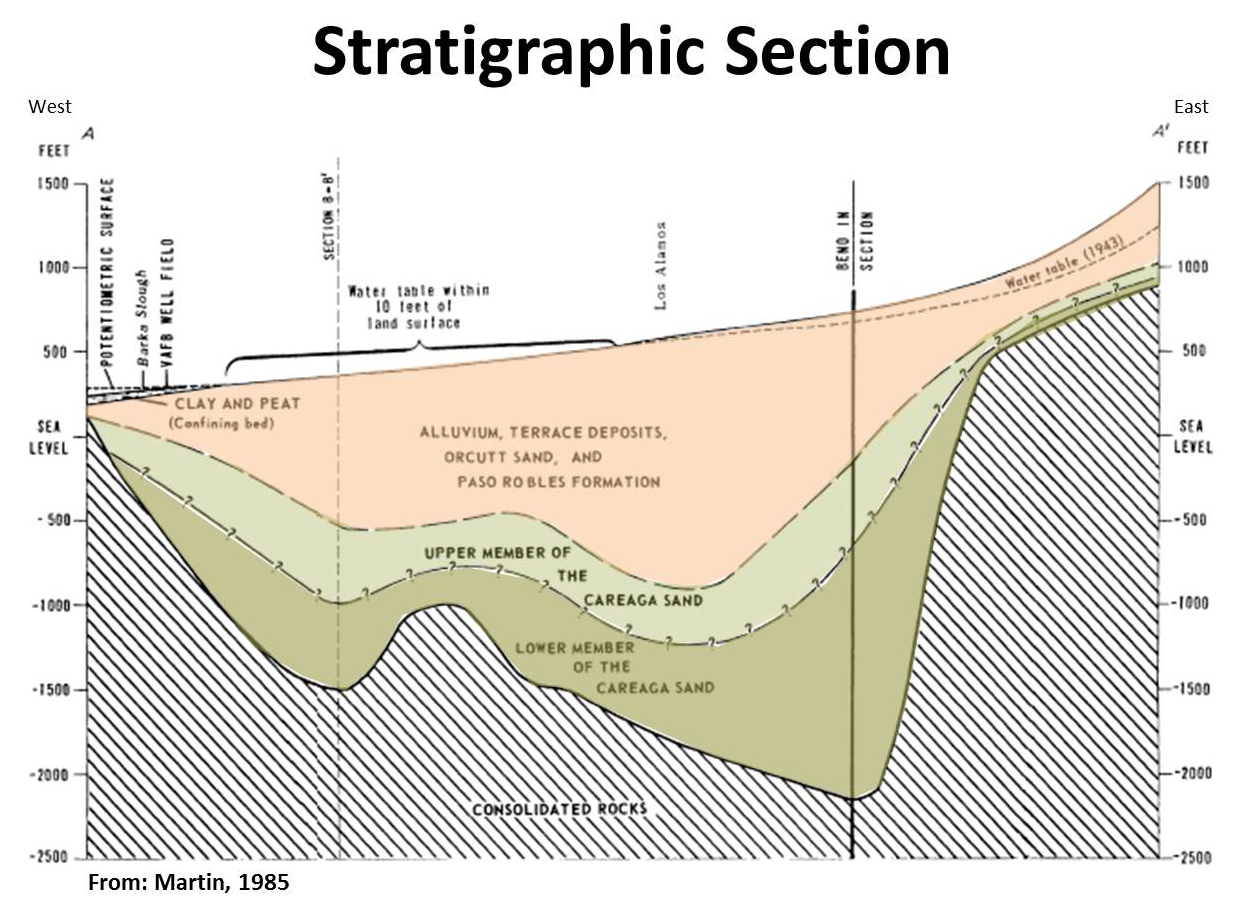
Generalized stratigraphic profile of the San Antonio Creek Valley (Martin, 1985). The consolidated rocks are sedimentary rocks, predominantly marine in origin, that are nearly impermeable except for slightly permeable sandstones and for fracture zones. The consolidated rocks form the lower boundary of the aquifer and also form much of the perimeter boundary of the groundwater basin. Location of profile within the valley is shown here.
Related Publications
Geologic map of the Casmalia and Orcutt quadrangles, Santa Barbara County, California
Geologic map of the Sisquoc quadrangle, Santa Barbara County, California
Geologic map of the Foxen Canyon quadrangle, Santa Barbara County, California
Geologic map of the Zaca Lake quadrangle, Santa Barbara County, California
Geologic map of the Lompoc and Surf quadrangles, Santa Barbara County, California
Geologic map of the Los Alamos quadrangle, Santa Barbara County, California
Geologic map of the Zaca Creek quadrangle, Santa Barbara County, California
Geologic map of the Los Olivos quadrangle, Santa Barbara County, California
Recharge Model
The historical water budgets have indicated that infiltration from ephemeral streamflow during winter runoff events is a major source of recharge to the groundwater system. Similarly, groundwater discharge to Barka Slough is the major natural discharge from the basin and is critical for maintaining riparian wetland habitat supporting endangered species. For these reasons, as part of a comprehensive hydrologic investigation, the USGS is making field measurements that are the basis for independent estimates of groundwater/surface-water interactions; these estimates will be used to inform and constrain estimates from hydrologic models.
Groundwater recharge is one of the largest unknowns in the hydrologic budget of the San Antonio Creek Valley. Many methods have been developed and used over the years to quantify these rates throughout various portions of the San Antonio Creek Valley. Significant year-to-year variability in precipitation in the Valley can lead to highly variable recharge. The Southern California region is greatly influenced by the Pacific Decadal Oscillation, and El Niño and La Niña events, which together have a marked effect on recharge. Therefore, several methods will be evaluated and used to help quantify the uncertainty in the recharge component of the water budget.
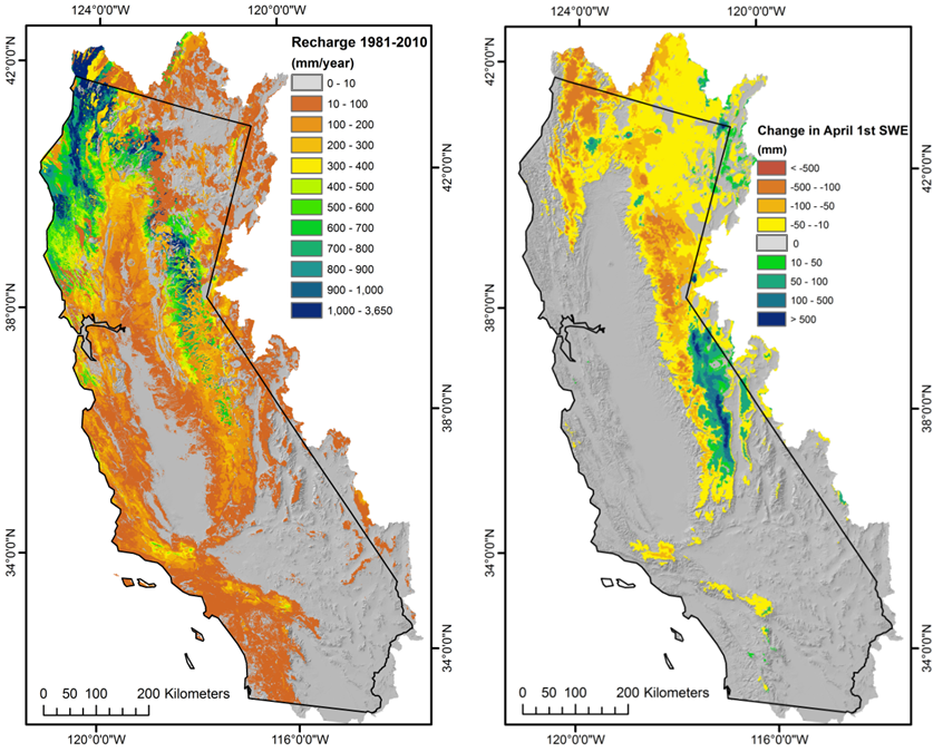
Maps of hydrologic output variables for (a) average recharge (net infiltration below the root zone) for water years 1981-2010 and (b) change in average April 1st snow water equivalent (SWE) between 1951-1980 and 1981-2010 calculated by the Basin Characterization Model for the California hydrologic region. Source: L.E. Flint and A.L. Flint, 2014, California Basin Characterization Model: A Dataset of Historical and Future Hydrologic Response to Climate Change, U.S. Geological Survey Data Release, doi:10.5066/F76T0JPB
Related Studies
Integrated Hydrologic Flow Model
A hydrologic flow model will be developed using MODFLOW, a three-dimensional finite-difference hydrologic model. The hydrologic model will be used to evaluate how selected water-use and climate scenarios could affect the availability of groundwater in the San Antonio Creek Valley. Potential water-use scenarios include changes in cropping patterns, increased urbanization, artificial recharge, and climate change.
The USGS will work with water managers and other stakeholders to help define the scenarios to be evaluated for this study. The assessment of these scenarios is intended to provide the stakeholders with a better understanding of the water resources and how they respond to various changes in the hydrologic system, the interaction between the supply and demand components of water use, and the potential changes in availability of the water resources under alternative climatic and water-use scenarios.
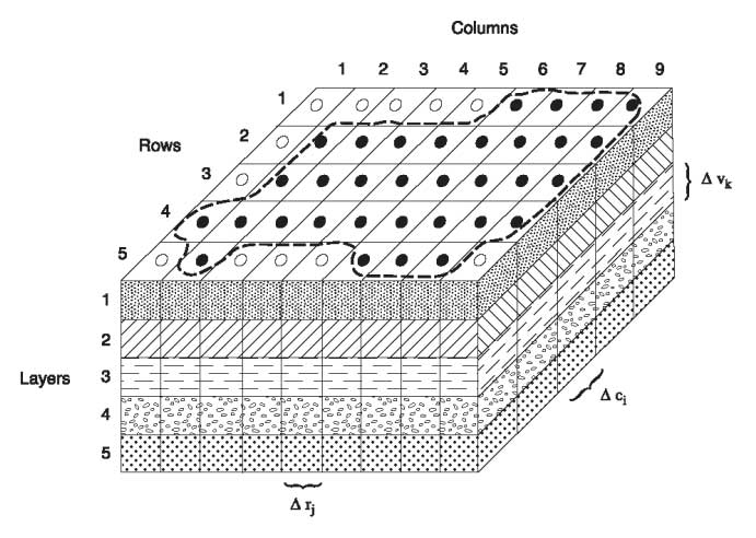
Spatial discretization of a hypothetical aquifer system with a grid of blocks called cells, the locations of which are described in terms of rows, columns, and layers.
Cooperating Agencies

Santa Barbara County Water Agency
![]()
Related USGS Publications
Appraisal of Ground-Water Resources in the San Antonio Creek Valley
Geology and Ground Water of San Antonio Creek Valley, Santa Barbara County, California
Groundwater Quality in the South Coast Range Coastal Groundwater Basins, California
Other Related Publications
San Antonio Creek Coordinated Resource Management Plan
Ground Water Quality and Hydrology Data, San Antonio Creek Basin
Potential Effects of Increased Ground-Water Pumpage on Barka Slough, San Antonio Creek Valley