

Regional Hydrology
Estimates of soil water deficit during California drought, January 1, 2014: U.S. Geological Survey Data Release

Figure 1. Water-supply basins in California that drain to the SF Bay Delta, and calculated soil-water deficit as of January 1, 2014 using the California Basin Characterization Model.
Because the following information has immediate and time-sensitive relevance to public health and welfare owing to the Governor's declared drought emergency it is being released as preliminary information. As preliminary information, it had been reviewed and approved to meet the needs for timely best science, but the methodology is subject to refinement. The information is provided on the condition that neither the U.S. Geological Survey nor the U.S. Government may be held liable for any damages resulting from the authorized or unauthorized use of the information. Future updates may be available using this website.
Deficits in soil moisture have the potential to reduce runoff as a result of rainfall or snowmelt replenishing the soil to field capacity prior to runoff. The loss of runoff during periods of drought may have large implications to the annual water supply generated from mountain watersheds. Soil water deficit was calculated from soil moisture storage simulated for Jan. 1, 2014 for 23 water-supply basins surrounding the California Central Valley (fig. 1) by using the monthly California Basin Characterization Model (Flint and others, 2013) and ArcGIS. The previously published model run was from 1896-2010 using the PRISM 800-m-grid transient climate data (Daly and others, 2008) that was downscaled to 270-m by using methods from Flint and Flint (2012) for application to the water balance model. The updated model extended the simulation period by using provisional PRISM monthly 4-km data to include 2011 through 2013. Estimated soil water storage for the month of December 2013 was subtracted from total storage values (field capacity multiplied by soil thickness) to produce a map of soil water deficit. It is assumed that soil storage will be filled to field capacity prior to generating runoff, and that total soil storage included soil that was drier than wilting point because of the likelihood that there were soils drier than wilting point due to extended drought. Estimates of the water necessary to fill this deficit were calculated for all basins at 500 m elevation bands (dataset).
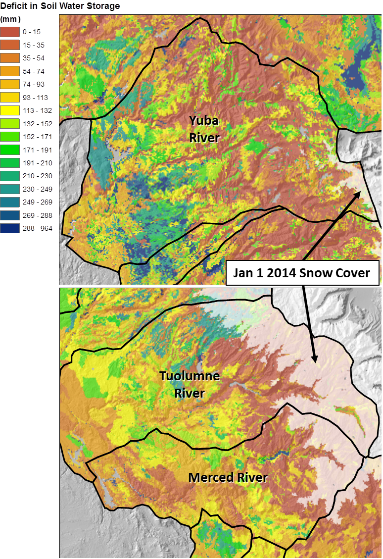
Figure 2. Close-ups of the Yuba River basin (top) and the Tuolumne and Merced River basins (bottom) showing calculated soil-water deficit as of January 1, 2014, and including simulated snow cover for each basin.
The variation in soil types and precipitation patterns across the region is reflected in soil water deficit conditions in the Yuba River basin, where there are deeper soils with additional deficit at lower elevations (fig. 2). In comparison, the Tuolumne and Merced River basins have shallower soils that require less replenishment from precipitation and snowmelt, especially at the higher elevations. The snow cover as of Jan 1, 2014 is indicated as transparent white over the colored deficit categories. In general, the current snow cover overlies areas of shallow soils where calculated deficits are relatively smaller. This suggests a there will be a reasonable decrease of the current deficit, and some runoff during the spring 2014 snowmelt.
It should be pointed out that, on the whole, this is a low estimate of the soil water deficit under extended drought conditions. In normal precipitation years, the water table maintains an elevation that is able to sustain baseflow in many headwater streams. During extended drought periods the water table declines to a point such that voids in subsurface shallow bedrock must also be filled in order to resume baseflow or generate runoff. The extent of this additional volume that needs to be replenished with precipitation is basin- and geology specific and could be estimated with additional analyses of water balance calculations for varying climatic conditions and with hydrograph separation techniques.
Data
View the Dataset (19KB)
Citation
L.E. Flint and A.L. Flint, 2014, Estimates of soil water deficit during California drought, January 1, 2014, U.S. Geological Survey Data Release, doi:10.5066/F7319SXX