
Regional Hydrology
Using the Basin Characterization Model (BCM) to Estimate Natural Recharge in Indian Wells Valley, California
Located in the northern Mojave Desert, the Indian Wells Valley has an arid environment, receiving only 4-6 inches of precipitation annually. Like most desert areas, Indian Wells Valley communities rely mostly on groundwater for their available groundwater supply. Increases in urban and agricultural development have resulted in increased groundwater pumpage for public and agricultural use, causing large water-level declines throughout the valley. Understanding the rate and amounts of natural groundwater recharge in the Indian Wells Valley is important to developing resource-management plans for the groundwater basin and the communities that depend on it.
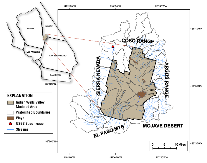
Study area of the Indian Wells Valley; Modeled area obtained from Berenbrock and Martin (1989).
Objective
The U.S. Geological Survey's Basin Characterization Model (BCM) is a tool scientists and resource managers can use to understand complex groundwater systems, and predict the effect potential climate scenarios may have upon a basin. Using climate trends and projections, the BCM is able to simulate the effects different climate scenarios may have upon a hydrologic system. USGS scientists can use this tool in conjunction with new, localized data, to better understand groundwater recharge in the arid Indian Wells Valley environment.
Working in cooperation with Kern County, the U.S. Geological Survey will revise an existing BCM to refine estimates of recharge in the Indian Wells Valley basin. This revised model will be used to estimate groundwater recharge values in the Indian Wells Valley basin, data that can provide a more accurate determination of water for meeting future human and environmental needs.
Science Plan
To address this project, the USGS will build upon the existing BCM, using all available information associated with the estimates of natural recharge, or data useful for model calibration. The model will be calibrated using simulated recharge from the updated groundwater-flow model streamflow data collected at the USGS streamgage located at Little Lake Creek, and other streamflow records.
The BCM model will be used to determine a variety of data sets, including
- Estimates of rooting depth and soil properties
- Recharge estimations
- Historical record of recharge distribution throughout the valley
- Potential effects of future climate projections on future changes in recharge runoff, evaporative demand, and irrigation demand.
The data revealed by this revised BCM model of the Indian Wells Valley basin will contribute to a better understanding of groundwater availability in this aquifer system, which will help in the development of management practices that may extend the useful life of the groundwater resources to meet current and foreseeable-future demands.
Cooperating Agency

USGS Contacts
Project Chief: Dina Saleh
Phone: 916-278-3070
Email: dsaleh@usgs.gov