
Analysis of the geohydrology and water-management issues of the Central and West Basins, Los Angeles County, California
 Problem: Nearly 300,000 acre-feet of water is pumped
annually from the Central and West Coast basins of Los Angeles County,
California. An additional 400,000 acre-feet of surface water is imported
for direct use. Water managers of these basins must deal with issues
relating to both water supply, such as declining ground-water levels,
and water quality. Important regional water-quality concerns include
seawater intrusion, inflow of contaminated water from the San Gabriel
basin, and naturally occurring constituents with concentrations exceeding
proposed State drinking-water standards. Current activities for protecting
the quantity and quality of the ground-water supplies include artificial
recharge in percolation ponds, injection at three sets of seawater barrier
wells, and in-lieu delivery of imported water to supplant ground-water
pumpage. To evaluate how these activities can be conducted most effectively,
it is necessary to analyze existing geohydrologic and geochemical data
and to collect and analyze new data to improve the understanding of
the two basins.
Problem: Nearly 300,000 acre-feet of water is pumped
annually from the Central and West Coast basins of Los Angeles County,
California. An additional 400,000 acre-feet of surface water is imported
for direct use. Water managers of these basins must deal with issues
relating to both water supply, such as declining ground-water levels,
and water quality. Important regional water-quality concerns include
seawater intrusion, inflow of contaminated water from the San Gabriel
basin, and naturally occurring constituents with concentrations exceeding
proposed State drinking-water standards. Current activities for protecting
the quantity and quality of the ground-water supplies include artificial
recharge in percolation ponds, injection at three sets of seawater barrier
wells, and in-lieu delivery of imported water to supplant ground-water
pumpage. To evaluate how these activities can be conducted most effectively,
it is necessary to analyze existing geohydrologic and geochemical data
and to collect and analyze new data to improve the understanding of
the two basins.
Objectives: The objectives of the study are (1) to quantitatively characterize the geohydrologic and geochemical systems in the Central and West basins and (2) to develop necessary analytic tools to evaluate water-management issues in the basins.
Relevance and Benefits: The study provides detailed understanding of the regional geohydrology of the Los Angeles Coastal Hydrologic Basin, one of the Nation's largest urban centers. It is an area of approximately 6 million people, and ground water provides about one-third of the water supply. It is expected that the data collected, the analytic tools developed, and the analyses completed will be used by multiple parties to address inter-basin and inter-agency water-management questions. The intensive drilling and associated data collection coupled with the collaborative work of the USGS Geologic Division will advance understanding of the link between geologic information and hydrologic processes.
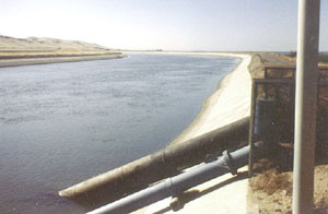
Approach: The study will include three major tasks; (1) compilation of existing data; (2) collection of new data; and (3) analyses of geohydrologic and geochemical data. Existing geographic, geohydrologic, and geochemical data will be compiled and entered into a computerized Geographic Information System (GIS). Multiple-completion monitoring wells will be installed to collect depth-dependent data. Water-quality samples will be collected from selected existing wells in the basins; the samples will be analyzed for constituents, such as isotopes, that were not previously analyzed. An understanding of the three-dimensional ground-water-flow system and the geochemistry of the flow system will be defined/refined. The potential implications--for water-management purposes--of this improved understanding will be evaluated. Ground-water simulation and optimization techniques will be developed to evaluate water-management questions.
Progress and Significant Results in FY 1999: A detailed analysis of the geohydrology and geochemistry of the area around the Dominguez Gap Barrier Project was completed. Extensive water-quality and geophysical data were collected and analyzed. The draft of a report describing the results was completed. Ten multi-completion monitoring wells were drilled; at Long Beach-1, continuous coring was conducted in a 4-week collaborative effort by the Geologic and Water Resources Divisions of the USGS and the Water Replenishment District. The ground-water simulation model was updated to extend through 1998. Additional simulations were run to address specific water-management scenarios. The model was linked with optimization techniques to evaluate strategies for meeting water demand and controlling seawater intrusion in the West Coast Basin.
Plans for FY 2000: The optimization model will be used to evaluate additional management concerns in the West Coast Basin, including barrier operation and control of the chloride plume, and to address other issues, including recharge and storage options in the Los Angeles Forebay. Additional water-quality sampling and geophysical logging will be conducted in the area of the Dominguez Gap Barrier Project (DGBP). Geophysical-geochemical data collection will begin along parts of the West Coast Basin Barrier Project (WCBBP). The WCBBP is the largest injection project and the only project that is currently using reclaimed water. The ground-water flow system and the hydrostratigraphy differ from that at the DGBP. The proposed data collection and analysis will provide a useful complement and contrast to the DGBP work. At least three additional multi-completion monitoring wells will be drilled. Collaboration with linked Geologic Division projects in the Los Angeles Basin (including the Coastal and Marine Geology Coastal Aquifers study and the FOQUS-LA project) will continue.
Number: CA512
Location: Los Angeles County
Cooperating Agencies: Water
Replenishment District of Southern California
Project Chief: Michael Land
Period of Project: October 1994 through Present
Team:Steven Crawford, Rhett Everett, Randy Hanson, Mark Newhouse,
Steve Predmore, Tyler Johnson