California's Central Valley
Delta-Mendota Canal: Evaluation of Groundwater Conditions & Land Subsidence
Extensive groundwater withdrawal from San Joaquin Valley aquifer system has caused renewed land-surface elevation drop (subsidence) that could result in serious operational and structural issues for the Delta-Mendota Canal (DMC). In response, the USGS is studying and providing information on groundwater conditions and land subsidence in the San Joaquin Valley.
Regional Setting and Historical Context
Groundwater pumping caused widespread compaction and resultant land subsidence between 1926 and 1970, locally exceeding 26 feet. Surface-water imports in the early 1970s resulted in decreased pumping, reduced compaction rate, and a steady recovery of groundwater levels. However, lack of imported surface-water availability during 1976-77, 1986-92, and 2007-09 caused groundwater-pumping increases, renewed compaction, and declines in water-levels to near-historic lows. The resulting land subsidence has reduced the freeboard and flow capacity of the Delta-Mendota Canal, the California Aqueduct, and other canals that transport floodwater and deliver irrigation water , requiring expensive repairs.
One area of the Central Valley, southwest of Mendota, has experienced some of the highest levels of subsidence in California. From 1925 to 1977, this area suffered over 29 feet of subsidence.
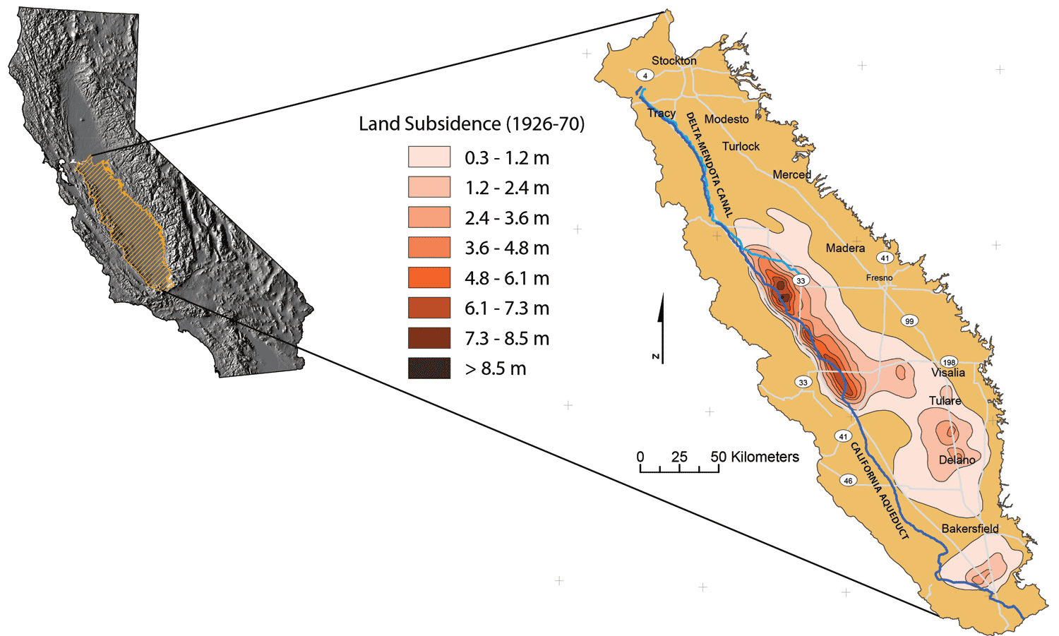
Land subsidence in the San Joaquin Valley, California, 1926-70 (modified from Ireland and others, 1984).
The Delta-Mendota Canal
The canal begins at the C.W. Bill Jones Pumping Plant, which pumps water 197 feet from the Sacramento-San Joaquin Delta. The canal runs south along the western edge of the San Joaquin Valley, parallel to the California Aqueduct for most of its journey, but it diverges to the east after passing San Luis Reservoir, which receives some of its water. The water is pumped from the canal and into O'Neill Forebay. Then it is pumped into San Luis Reservoir by the Gianelli Pumping-Generating Plant. Occasionally, water from O'Neill Forebay is released into the canal. The Delta-Mendota Canal ends at Mendota Pool, on the San Joaquin River near the town of Mendota, 30 miles west of Fresno.
Study Objectives
- improve the understanding of groundwater conditions and land subsidence and how groundwater resources have changed over time
- determine the location, extent, and magnitude of changes in land-surface elevation along the DMC for 2003-10 using persistent scatterer Interferometric Synthetic Aperture Radar (InSAR) methods
- develop and implement an approach to use persistent scatterer InSAR to monitor subsidence along the DMC
- develop groundwater flow and land-subsidence simulations to provide stakeholders with information to help manage and limit future land subsidence along the DMC
Delta-Mendota Canal Study
Cooperators
U.S. Bureau of Reclamation
San Luis & Delta-Mendota Water Authority
Publications
Water availability and land subsidence in the Central Valley, California, USA
Hydrology Journal, November, 2015
Water Availability and Subsidence in California's Central Valley
San Francisco Estuary & Watershed, September, 2015
Land Subsidence along the Delta-Mendota Canal in the Northern Part of the San Joaquin Valley, California, 2003-10
USGS Scientific Investigations Report, 2013
Groundwater Availability of the Central Valley Aquifer, California
USGS Professional Paper, 2009
Contacts
Groundwater Claudia Faunt
Phone 619.225.6142
Email ccfaunt@usgs.gov
Subsidence Michelle Sneed
Phone 916.278.3000
Email micsneed@usgs.gov