California's Central Valley
Central Valley Hydrologic Model: Texture Model
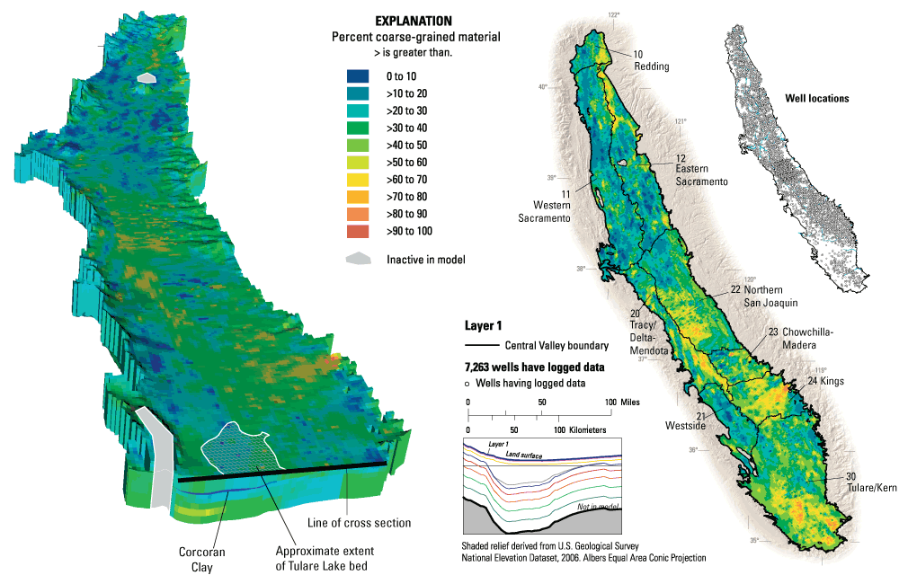
The figure on the left shows the kriged texture within the groundwater flow model. The illustration on the right depicts the kriged distribution of course-grained depostis for layers 1, 3, Corcoran Clay, 6, and 9 of the groundwater flow model. Information from 8,500 drillers' logs helped scientists create the 3D model of the characteristics of the Central Valley aquifer system (Faunt, 2010).
Geologic Texture Model Background
The Central Valley is a large structural trough filled with sediments of Jurassic to Holocene age, as much as 3 miles deep in the San Joaquin Valley, and as much as 6 miles deep in the Sacramento Valley.
In order to better characterize the aquifer-system deposits, lithologic data from approximately 8,500 drillers' logs of boreholes ranging in depth from 12 to 3,000 ft below land surface were compiled and analyzed to develop a 3-D texture model.
In general, the Sacramento Valley predominantly is fine-grained and reflects the more fine-grained volcanic-derived sediments. However, some relatively coarse-grained deposits do occur along the river channels and the alluvial fans emanating from the Cascade Range and the northern Sierra Nevada. In the San Joaquin Valley, especially on the eastern side, the areas of coarse-grained texture are more widespread than the areas of fine-grained texture and occur along the major rivers. This area of predominately fine-grained texture is associated with the largest amount of subsidence attributed to groundwater withdrawals recorded in the valley.
Lateral and vertical variations in sediment texture affect the direction and rate of groundwater-flow as well as the magnitude and distribution of aquifer-system compaction, manifested as land subsidence. Therefore, the textural distribution was used to define the vertical and lateral hydraulic conductivity and storage property distributions for the CVHM.
Methods
The primary variable selected for the geostatistical analysis was the percentage of coarse-grained material defined over 15-m borehole composite intervals. The utilization of the percentage of coarse-grained deposits, or texture, was based on a methodology developed in earlier works by Page (1983, 1986), Laudon and Belitz (1991), and Burow et al.(2004). Textural data were compiled from drillers' logs of wells and boreholes drilled in Central Valley.
Regions and Domains
Because of the large size of Central Valley and multiple depositional environments, the study area was split spatially into regions (See map below, left). The Sacramento Valley was divided based on groundwater basins: the Redding basin and the two groups of subbasins east and west of the Sacramento River. The subdivision of the San Joaquin Valley is complex because it is divided laterally and vertically. Laterally, the domains consist of groupings of similar groundwater subbasins (below, left). However, the hydrogeology of the San Joaquin Valley is dominated by the Corcoran Clay. Therefore, where this clay exists, the regions were subdivided above and outside the extent the Corcoran Clay. This resulted in two more domains: the Corcoran Clay and the area below the clay. Thus, to assure statistical validity of a domain, 17 domains were identified.
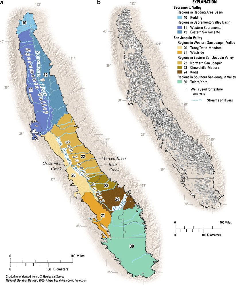
(a) Map of Central Valley showing groundwater basins and subbasins, groups of basins and subbasins into spatial provinces and domains for textural analysis, and (b) distribution of wells used for mapping texture.
Well Data Classification
A database was constructed to organize information on well construction and subsurface lithology in the study area. More than 150,000 optically scanned drillers' logs were obtained from the California Department of Water Resources, and a subset of good-quality logs that were spatially distributed throughout the valley were ultimately selected for use in the texture model.
Each lithologic log was divided into a discrete binary texture classification of either "coarse grained" or "fine grained" intervals on the basis of the description in the log. In this study, coarse-grained sediment is defined as consisting of sand, gravel, pebbles, boulders, cobbles, or conglomerate. Fine-grained sediment is defined as consisting principally of clay, lime, loam, mud, or silt. For use in statistical and geostatistical analysis, the percentage of coarse-grained texture was calculated over 15-m depth increments in the 8,497 logs in the database. This regularized data set consists of 46,878 data values of percentage of coarse-grained texture, referred to in this report as "texture values," from 8,497 drillers' logs. General statistical analyses were computed to examine spatial changes in percentage of coarse-grained deposits (count, mean, and standard deviation), both laterally and with depth. The global mean percentage of coarse-grained texture is 36%, with a standard deviation of 32%.
Preliminary analysis of the drillers' logs indicated that this resulted in logs yielding sufficient detail to map the texture at 15-m depth intervals on a 1.6-km grid. A total of 15-m composite intervals were chosen based on the data distribution, density in the drillers' logs, and trends in the data. Ninety-five percent of the intervals were less than 15 m thick and the average thickness of the intervals was 4.7 m. On average, 20 intervals per hole were defined and more than 80% of these holes had ten or more different lithologic characteristics in each per hole.
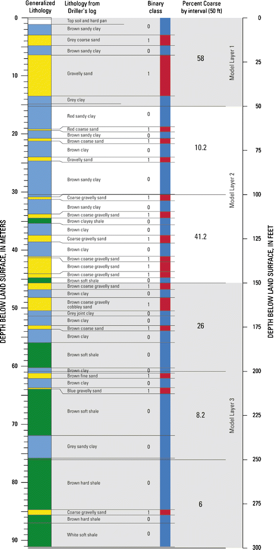
Diagram showing the process of interpreting the texture from the driller's descriptions. The original drillers' intervals are identified, the binary classification of coarse (1) or fine (0), and the regularization over the 15-m depth intervals to develop the percentage of coarse-grained deposits. In addition, the correlation of the 15 m texture lattice with the flow-model grid is shown.
Geostatistical Modeling Approach
Geostatistics is a set of applications and statistical techniques used to analyze spatial and (or) temporal correlations of variables distributed in space and/or time (Isaaks and Srivastava, 1989). A geostatistical model provides the best linear unbiased estimate and provides a set of weights that minimize estimation error (Journel and Huijbregts, 1978). In addition, the model is fitted to the observed spatial correlation structure, whereas simple interpolation methods are based on an assumed spatial correlation structure. Furthermore, anisotropy in the spatial correlation structure can be modeled by combining several different models aligned along the principal axis of anisotropy to form a nested set of models.
A number of geostatistical methods exist. The geostatistical method, ordinary kriging, was employed in this study. The method used is similar to those used by Burow et al. (2004). The depositional environments, as well as the magnitude, type, and distribution of data were used to determine the geostatistical approach and variables. Although estimation variance is an important piece of information for this study and future data gathering, little focus is placed on it in this article.
Modeling of the entire Central Valley using a single 3D variogram could not be done without violating the stationarity condition. To allow more locally customized variograms, the area was split up into zones of interpreted different depositional environment. This procedure of subdividing an aquifer complex into units of apparent stationarity is in essence equivalent to traditional stratigraphic delineation. In a regional basin-fill aquifer complex it is, however, difficult to correlate stratigraphic units.
Three-Dimensional (3D) Model of Percentage of Coarse-Grained Texture
The grid used for the groundwater flow model is the same as the texture grid in the lateral direction, but vertically included 10 layers rather than 46 layers. In general, the groundwater-flow model layers range from 15 to 1250 meters thick, increasing with depth. Where the Corcoran Clay exists, the layers were morphed to allow the explicit representation of the clay by layers 4 and 5. In order to complete this representation, the relative thicknesses of layers 1 through 3 above the clay were also modified. Any additional thickness was added to layer 3 as necessary to reach the depth of the top of the Corcoran Clay. The texture value for each layer could be set by taking the minimum, maximum, or averaging the percent coarse value for the appropriate model layer. In this representation, the percent coarse values were averaged vertically within each model cell. Because layer 1 of the texture model is identical to that of the texture lattice, the percent coarse values are identical. Likewise, layers 4 and 5 within the Corcoran Clay correspond to the 2D kriged values. Layers 4 and 5 are identical and are replicated in the groundwater flow model to allow for more accurate calculation of storage properties and subsidence. Outside of the area of the Corcoran Clay, layers 4 and 5 do not exist and are considered phantom layers and are kept only to keep track of numbering.
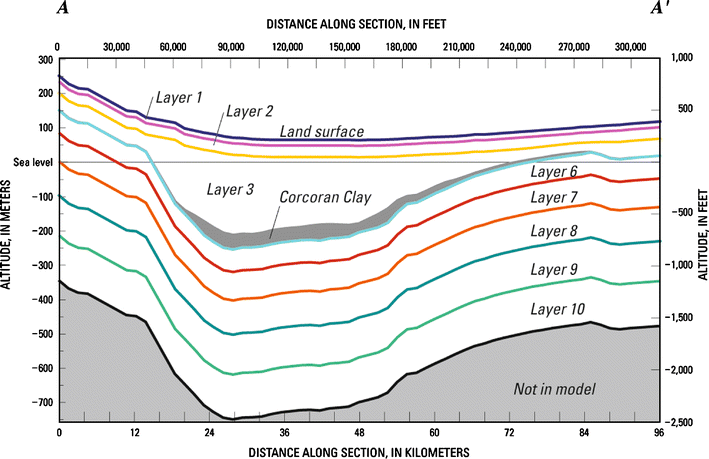
Generalized hydrogeologic section (A-A') indicating the vertical discretization of the numerical model of the groundwater flow system in Central Valley, California.
Learn More about the CVHM
Contacts
Project Chief: Claudia Faunt
Phone: 619.225.6142
Email: ccfaunt@usgs.gov
Data
 Model Datasets:
- Central Valley Spatial Database (Raw Data)
- Central Valley Hydrologic Model Database (Processed Data) ZIP (52.8 MB)
 Numerical Model Data files:
 Texture Model Data files:
Publications
Water availability and land subsidence in the Central Valley, California, USA
Hydrology Journal, November, 2015
Water Availability and Subsidence in California's Central Valley
San Francisco Estuary & Watershed, September, 2015
California's Central Valley Groundwater Study: A Powerful New Tool to Assess Water Resources in California's Central Valley
U.S. Geological Survey Fact Sheet 2009-3057
Groundwater Availability of the Central Valley Aquifer, California
U.S. Geological Survey Professional Paper 1766
Development of a three-dimensional model of sedimentary texture in valley-fill deposits of Central Valley, CA, USA
Hydrogeology Journal (2010) 18: 625-649
The Farm Process Version 2 (FMP2) for MODFLOW-2005 - Modifications and Upgrades to FMP1
U.S. Geological Survey Techniques and Methods 6-A-32