
Evaluation of the Hydrologic System and Selected Water-Management Alternatives in the Owens Valley, California
HYDROLOGIC SYSTEM
- Precipitation and Evapotranspiration
- Surface-Water System
- Ground-Water System
Download the contents of this page as a pdf file (1.1MB)
Download all Hydrologic System pages as a single pdf file (3.3MB)
Download the entire report as a pdf file (8.3MB)
Precipitation and Evapotranspiration
Precipitation
The pattern of precipitation throughout the Owens Valley is strongly influenced by altitude, and precipitation varies in a predictable manner from approximately 4 to 6 in/yr on the valley floor to more than 30 in/yr at the crest of the Sierra Nevada on the west side of the valley (Groeneveld and others, 1986a, 1986b; Duell, 1990; Hollett and others, 1991, fig. 3). On the east side of the valley, precipitation follows a similar pattern, but with somewhat lower rates of 7 to 14 in/yr because of the lower altitude of the Inyo and the White Mountains and the rain-shadow effect caused by the Sierra Nevada. Snow, when present on the Sierra Nevada and the White Mountains, commonly is absent on the Inyo Mountains (figure 3) and the Coso Range. Of the total average annual precipitation in the Owens Valley drainage area, about 60 to 80 percent falls as snow or rain in the Sierra Nevada, primarily during the period October to April. A lesser quantity falls during summer thunderstorms.
As shown in figure 7A, the pattern of average precipitation is well defined by the more than 20 precipitation and snow-survey stations that have been monitored routinely, many for more than 50 years (figure 7C). Average precipitation tends to increase from south to north, much as does altitude of the land surface. The strong correlation between altitude and recent mean annual precipitation can be seen in figure 7B and can be described by the regression equation,
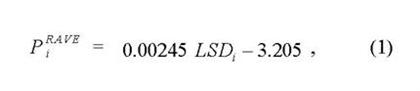
where PRAVE is recent mean annual precipitation, in inches per year, on the basis of data for rain years 1963—84; LSD is altitude of land surface, in feet above sea level; and i is an index referring to location.
Regression equation 1 was fitted by hand from figure 7B, which is a graph of data presented in figure 7C, with an emphasis on data from the west side of the valley where the bulk of the more transmissive materials of the ground-water system are present (figure 4). Predictably, the White Mountain Stations 1 and 2 (sites 19 and 20, figure 7B) fall somewhat below the line. A similar relation that more accurately represents precipitation falling on the east side of the valley could be developed (Lopes, 1988, fig. 3). However, that relation would need to account for the difference between the quantity of precipitation falling on the White Mountains and farther south on the Inyo Mountains (figure 3)—only part of which seems to be attributable to a difference in altitude of the two mountain ranges.
The time period (rain years 1963—84) used to develop equation 1 was chosen on the basis of two criteria: a nearly complete record for all 20 stations and symmetry with the period selected for calibration of the ground-water flow model. Because very little precipitation occurs in the Owens Valley during July through September, precipitation values for a rain year (July 1—June 30) are virtually identical to values for the corresponding water year (October 1—September 30), which is used to summarize streamflow and ground-water pumpage data. Equation 1 can be generalized for a much longer period of record using data for the U. S. Weather Bureau station at Independence (site 10, figure 7C). Long-term mean annual precipitation at this station, for the 99-year period 1886—1985, is 5.10 in/yr (M.L. Blevins, Los Angeles Department of Water and Power, written commun., 1986)—in comparison with 5.98 in/yr for rain years 1963—84. Scaling equation 1 by the ratio 5.10/5.98 produces an estimate of the longterm mean annual precipitation (PLTAVE) at any location along the west side of the valley. This relation is:
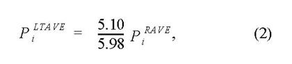
where units of both PLTAVE and PRAVE are inches per year. Precipitation (Pi, jAN) for a particular year (j) can be estimated by using annual precipitation at the Independence station (PInd, jAN) for that same year as a weighting factor:
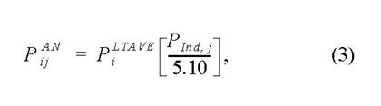
where PAN is annual precipitation, in inches per year; PLTAVE is long-term mean annual precipitation, in inches per year; and PInd is annual precipitation at the U.S. Weather Bureau station at Independence, in inches per year. Estimates of precipitation based on equations 1, 2, and 3 for locations on the valley floor need to be used cautiously because of significant local variability in precipitation (figure 7B).
Although the spatial distribution of mean annual precipitation is well documented and highly correlated with altitude (figure 7B), the spatial distribution of precipitation during specific years is highly variable (Hollett and others, 1991, fig. 3). For example, annual precipitation at Bishop and at Independence was compared for rain years 1935—88 (figure 8). On average, similar quantities of precipitation fall at Bishop and at Independence (sites 2 and 10, respectively, figure 7C). This similarity occurs because both sites are located on the valley floor and differ in altitude by less than 160 ft. As shown in figure 8, however, it is not uncommon for either site to have more, sometimes much more, precipitation during a particular year. C.H. Lee (1912, p. 15) noted that the high variability in precipitation in the Owens Valley is the result of the three distinct types of storms that occur in the area: (1) north Pacific storms that dominate the rainy season and provide most of the precipitation both to the mountain areas and the valley floor, (2) south Pacific storms that migrate north up the valley (usually a few times each year) generating sporadic precipitation, but favoring neither the Sierra Nevada nor the Inyo Mountains, and (3) local storms which occur during summer and which are an important contributor to total precipitation on the east side of the valley. This annual and seasonal variability makes continued monitoring of precipitation at various sites throughout the valley important—especially because both the quantity and the timing of precipitation on the valley floor play a critical role in the water use and the health of native vegetation (Sorenson and others, 1991). Ground-water recharge from precipitation is highly dependent on the quantity of water used by the overlying vegetation and is discussed in the next section on evapotranspiration.
Evapotranspiration
Evapotranspiration by the dominant native vegetation of the valley had not been measured since the detailed lysimeter studies by C.H. Lee (1912) in the early 1900's. Instead, evapotranspiration was estimated as the residual, a very large residual, in numerous water-budget studies (California Department of Water Resources, 1960, 1965, 1966; Los Angeles Department of Water and Power, 1972, 1976, 1978, 1979; Danskin, 1988). A key element of the cooperative studies begun in 1982 by the U.S. Geological Survey, Inyo County, and the Los Angeles Department of Water and Power was to measure evapotranspiration at representative vegetation study sites throughout the valley (figure 2), to relate these data to soil and plant characteristics at the sites, to extend the relations to quantify evapotranspiration throughout the valley, and then to synthesize the results in an analysis of the overall hydrologic system.
As part of the studies of native vegetation, Duell (1990) used micrometeorologic equipment to collect detailed evapotranspiration measurements during 1984—85, a period of relatively abundant surface water and ground water in the valley. The results for high ground-water alkali meadow and alkali scrub communities (figure 6 and table 3), which are summarized in table 5, show that evapotranspiration rates on the valley floor ranged from about 12 in/yr to about 45 in/yr depending on the type and percentage of vegetative cover. Assuming that these rates are representative of average conditions on the valley floor where the depth to water is approximately 3 to 15 ft, then evapotranspiration is about 3 to 6 times greater than the quantity of precipitation that is available.
During the same period and at the same sites, Groeneveld and others (1986a, 1986b) collected transpiration measurements from native vegetation using a porometer, an instrument that encloses a few leaves of a plant and measures water-vapor flux (Beardsell and others, 1972). These measurements can be converted to transpiration from an entire site using measurements of total leaf area per plant and plant density per site. Results from Groeneveld and others (1986a, p. 117) suggest that most of the evapotranspiration measured by Duell (1990) is transpiration from native vegetation.
Coincident monitoring of soil moisture at the same sites indicated that most of the transpired water came from the unsaturated zone, including that part just below the land surface. These findings indicate that the plants, although originally classified as phreatophytes, might be described more accurately as facultative phreatophytes (Sorenson and others, 1991). However, one common plant on the valley floor, Atriplex torreyi (Nevada saltbush) (tables 3 and 5), was found to be restricted to shallow-ground-water zones. The phenology, reproductive processes, and flooding tolerance of Atriplex torreyi suggests that it is an obligate phreatophyte in the Owens Valley (Groeneveld, 1985). This species also was found by Dileanis and Groeneveld (1989) to be among the most drought tolerant of the dominant species on the valley floor.
Soil-moisture monitoring also indicated that much of the precipitation that falls on the valley floor (figure 7) percolates into the near-surface unsaturated zone and later is transpired by native vegetation (Sorenson and others, 1991). Except during brief periods of rainfall or snowmelt, or in areas where the water table is nearly at the land surface, evaporation is not a dominant part of evapotranspiration from the valley floor.
The findings of Duell (1990) and Groeneveld and others (1986a, 1986b; 1987) were combined with extensive mapping of vegetation by the Los Angeles Department of Water and Power (D.D. Buchholz, written commun., 1988) in order to produce an estimate of average annual transpiration from the valley floor (figure 9). The mapping was done in the field using aerial photographs and land-use maps. Data collected for each mapped area (parcel) included information about plant communities, species composition, percentage of bare ground, and land use. The data were compiled on topographic maps at a scale of 1:24,000 and then digitized into data points every 250 m (820 ft) based on the Universal Transverse Mercator grid system (Synder, 1982, 1985, 1987; Newton, 1985). These individual data points of total evapotranspiration were combined with regressed values of precipitation (figure 7) and averaged using the grid of the valleywide groundwater flow model. Evaporation from the water table was assumed to be negligible for most areas of native vegetation and to be of minor importance in the limited areas of riparian plants. To maintain consistency with analysis of the same data done by the Los Angeles Department of Water and Power (R.H. Rawson, written commun., 1988), about 50 percent of the precipitation on the valley floor was assumed to evaporate. This percentage is reasonable but has a high degree of uncertainty (D.N. Tillemans, Los Angeles Department of Water and Power, oral commun., 1987). The resulting transpiration values for native vegetation are summarized in figure 9.
Transpiration by native vegetation from most of the valley floor is less than 1.0 ft/yr, and transpiration from much of the valley floor, particularly along the east side of the valley, is less than 0.5 ft/yr. These estimates are generally lower than previous estimates of transpiration by native vegetation (R.H. Rawson, Los Angeles Department of Water and Power, written commun., 1986) and are lower than calculated values obtained by subtracting a percentage of precipitation from estimated evapotranspiration (Danskin, 1988; C.H. Lee, 1912). This reduction in transpiration is consistent with the lower values of valleywide evapotranspiration calculated by Hollett and others (1991, table 6) in comparison with values from prior studies (C.H. Lee, 1912; Los Angeles Department of Water and Power, 1974b, 1975, 1976, 1978, 1979; Danskin, 1988). These prior studies quantified transpiration or evapotranspiration for periods before the additional diversions of water from the valley in 1913 and 1970. The additional diversions reduced the quantity of water available for transpiration by native vegetation.
In a few areas of the valley floor, infiltration to the water table may occur during part of the year. For example, in meadow areas, such as east of Independence, the water table is nearly at the land surface in winter months and some precipitation likely percolates to the saturated ground-water system. However, the high annual evapotranspiration rates observed by Duell (1990) in those areas—for example, at site L (table 5 and figure 2)—indicate that the meadow areas are net discharge points from the ground-water system. Any water that infiltrates in winter is removed in summer. In other parts of the valley floor, such as small alkali flats or patches that are almost devoid of vegetation (figure 3), net infiltration may result during unusually wet periods when rainfall or local runoff exceeds evapotranspiration. The quantity of infiltration from such microplaya areas, however, is very small because of extremely slow infiltration rates through these characteristically fine-textured, deflocculated soils (Groeneveld and others, 1986a). As in the meadow areas, wet conditions generally are present only in winter, and all the water infiltrated (perhaps with some additional ground water) is removed in summer when evapotranspiration rates increase markedly (Duell, 1990, fig. 24). For the area of the valley fill simulated by the valleywide groundwater flow model (figure 4), average net discharge by evapotranspiration from the saturated aquifer system was estimated to decrease from 112,000 acre-ft/yr for water years 1963—69 to 72,000 acre-ft/yr for water years 1970—84.
In the alluvial fan deposits and volcanic rocks, the depth to water ranges from many tens to many hundreds of feet. Extraction of water by plants from the saturated ground-water system is not possible, and the plants subsist on direct precipitation. Because the precipitation rates are higher than those on the valley floor (figure 7), some recharge to the ground-water system may occur. However, the density of vegetation also is greater at the heads of fans and may balance the increased precipitation (M.O. Smith and others, 1990a, b). Any precipitation that does infiltrate past the root zone eventually recharges the saturated ground-water system, probably at a relatively uniform rate, and flows toward the center of the valley. About 16 percent of the direct precipitation on the alluvial fan areas was estimated to recharge the ground-water system (C.H. Lee, 1912). This percentage equates to about 1.25 to 2.75 in/yr of recharge. Ground-water simulation studies suggest that these rates may be too high and that maximum values of from 0.5 to 1.0 in/yr are more likely (Danskin, 1988; Hutchison, 1988; Hutchison and Radell, 1988a, b; Los Angeles Department of Water and Power, 1988). An investigation of recharge from precipitation in other arid regions indicated that recharge did not occur until precipitation rates exceeded about 8 in/yr (Mann, 1976, p. 368). The area of valley fill in the Owens Valley that has an average precipitation of more than 8 in/yr is limited to the higher attitudes, mostly along the western alluvial fans (figure 7A). On the basis of these findings, equation 2 was used to calculate 5 percent of the average annual precipitation for values greater than 8 in/yr (figure 7A). For the defined aquifer system (figure 2), the total quantity of infiltration from direct precipitation, which occurs primarily on the alluvial fan deposits and volcanic rocks, averages approximately 2,000 acre-ft/yr. Detailed evapotranspiration data on the alluvial fans will help to confirm this approximation.
These conclusions about recharge from precipitation and discharge from evapotranspiration are in general agreement with the assumptions made in previous water-budget studies by C.H. Lee (1912), Los Angeles Department of Water and Power (1972, 1976, 1978, 1979), Hutchison (1986b), and Danskin (1988) and in soil-moisture studies by Groeneveld (1986), Groeneveld and others (1986a, 1986b), and Sorenson and others (1991). All the studies assume that a minimal quantity of recharge occurs from direct precipitation on the valley floor, generally less than 10 percent of the average precipitation rate, and that a somewhat greater potential for recharge from direct precipitation is present on the alluvial fan deposits and volcanic rocks.
An important difference between this study and those done prior to 1983, when the fieldwork and model simulations for this study were begun, is the assumption of a lower infiltration rate from direct precipitation on the alluvial fan and volcanic areas. The lower infiltration rate multiplied by the large size of the affected area results in a substantially lower value of recharge to the saturated ground-water system. This decrease in recharge is matched by a similar decrease in discharge by evapotranspiration from the valley floor. In general, average evapotranspiration rates measured by Duell (1990) and transpiration rates measured by Groeneveld and others (1986a, 1986b) are lower than previous estimates and support the assumption of lower recharge rates from direct precipitation. Because of the recent collection of detailed evapotranspiration data on the valley floor, recharge from direct precipitation on the alluvial fan deposits and volcanic rocks is now the least quantified part of a valleywide ground-water budget. Additional evapotranspiration measurements or soil-moisture studies in these areas would help to confirm present water-budget estimates.
Questions about Owens Valley Hydrogeology? Please contact Wes Danskin (email or address). 619.225.6132
California Water Science Center Home Page