Mojave Groundwater Resources
2018 Mojave Region Water-Level Study
REGIONAL WATER TABLE (2018) IN THE MOJAVE RIVER AND MORONGO AREAS, SOUTHWESTERN MOJAVE DESERT, CALIFORNIA by Meghan C. Dick and Whitney Seymour
2018 Groundwater Levels
Data for groundwater-levels measured in 707 wells during January-July 2018 by the U.S. Geological Survey (USGS), the Mojave Water Agency (MWA), and other local water districts were compiled to construct a regional water-table map which can be viewed as part of an interactive water data map. The regional water-table map shows the elevation of the water table in and around the Mojave River and Morongo areas, in San Bernardino County, California. Due to the dynamic nature of the interactive map, some features referenced in the text may not be visible until zooming in on the map. Previous hydrologic studies (Izbicki and others, 1995; Stamos and Predmore, 1995; Stamos and others, 2001) have modified the boundaries of El Mirage Valley, Upper Mojave River Valley, Middle Mojave River Valley, Lower Mojave River Valley, Harper Valley, Coyote Lake Valley, and Caves Canyon Valley groundwater basins defined by the California Department of Water Resources (California Department of Water Resources, 2016) and herein are collectively referred to as the Mojave River area. Similarly, Trayler and Koczot (1995) modified the boundaries of the Lucerne Valley, Johnson Valley, Means Valley, Bessemer Valley, Ames Valley, Deadman Valley, Twentynine Palms, Copper Mountain Valley, Warren Valley, and Joshua Tree groundwater basins (California Department of Water Resources, 2016) and herein are collectively referred to as the Morongo area. Groundwater levels from the USGS and MWA were measured and compiled as described in the Groundwater Technical Procedures of the USGS (Cunningham and Schalk, 2011). Groundwater levels from other local water districts were measured according to the procedures established by the corresponding agency. Groundwater-level measurements that were furnished by other local water districts but did not meet USGS standards for inclusion in the USGS National Water Information System (U.S. Geological Survey, 2023) are available from the respective well owner upon request. All groundwater levels compiled for the 2018 study were compared to historical data for quality-assurance purposes.
Groundwater-level contours from the 2016 regional water-table map (Dick and Kjos, 2017) were used as a guide to shape the 2018 groundwater-level contours (Dick and Seymour, 2023). Contours are dashed (approximate) on the regional water-table map where data are sparse. Groundwater-level contours for all study years can be displayed on the interactive map by clicking the desired year under the “Water-level Contours” menu. The 2018 groundwater-level data used to create the contours can be displayed on the interactive map for the Mojave River and Morongo areas by clicking the desired year under the “Groundwater Data” menu. Groundwater-level data for 2018 are accessible through this website's data downloads page by following the Water-level Sites link for 2018 Sites (2018 study).
Groundwater-Level Changes
Groundwater-level data from the USGS National Water Information System were used to construct 37 groundwater-level hydrographs to show long-term (1930-2018) and short-term (1990-2018) groundwater-level changes in the Mojave River and Morongo areas. Groundwater-level changes between the spring of 2016 and 2018 were calculated by subtracting depth-to-water below land surface measured in the same well during 2016 and 2018. Groundwater-level changes between any of the study years on this website can be displayed on the interactive map by selecting the “Start Year” and “End Year” from the "Water-Level Changes” menu.
Long-Term Groundwater-Level Hydrographs
There are 25 long-term (1930-2018) hydrographs for the Mojave River and the Morongo areas. Three wells were destroyed or were unable to be measured in 2018 (wells 5N/5W-22E6, 11N/4W-29R1, and 11N/4W-30N1), but the historical groundwater levels are included because they are discussed in previous groundwater-level reports.
In some hydrographs, data from more than one well are included to show groundwater-level changes throughout long periods. Data from multiple wells were combined onto a single hydrograph for wells that went dry due to a decline in the groundwater table, or wells that could no longer be measured, and data from a nearby well could be used to continue the record. Data from different wells on the same hydrograph have differently colored data points.
Mojave River Area
The Mojave River area is divided into six subareas: Este, Alto, Oeste, Alto Transition zone, Centro, and Baja. The long-term hydrographs (1930-2018) for the Mojave River area indicate that groundwater levels generally:
- declined about 20 feet (ft) in the Oeste subarea since 1980 (well 6N/7W-10P2),
- declined more than 50 ft east of the Mojave River in the Alto subarea since the 1930s (well 4N/3W-1M1),
- declined about 57 ft in the eastern part of the Harper (Dry) Lake region of the Centro subarea since the 1930s (wells 11N/3W-28R1, -28R2),
- increased more than 18 ft southwest of Harper (Dry) Lake in the Centro subarea from 1998 to 2018 (well 10N/4W-10D1) because of a sustained reduction in groundwater pumping since the early 1990s (Mojave Basin Area Watermaster, 2019), and
- declined more than 110 ft in the Baja subarea since the late 1940s (wells 9N/2E-20Q1, -20K1, and -20G3).
Morongo Area
The Morongo area is divided into 17 subbasins. All the long-term hydrographs for the Morongo area showed declines in groundwater levels of variable magnitude since the wells were first measured. Groundwater levels generally:
- declined about 46 ft in the central area of the Joshua Tree subbasin since the late 1950s, and increased about 2 ft since 2015 (well 1N/7E-32C1) due to imported water deliveries ( Basin Area Watermaster, 2019),
- declined about 67 ft the Reche subbasin since 1963 (well 2N/6E-18B1),
- declined about 110 ft near Lucerne Lake in the Lucerne Valley subbasin between the early 1950s and the mid-1990s (well 5N/1W-25G1), but groundwater levels have recovered about 11 ft because of a sustained reduction in groundwater pumping since the mid-1990s,
- declined about 138 ft in the eastern part of the Surprise Spring subbasin since 1952 (well 2N/7E-2C1), and
- declined about 39 ft in the western part of the Warren subbasin between 1951 and 2018, and by more than 320 ft between 1951 and the early 1990s, but have increased about 260 ft since 1994 (wells 1N/5E-36K1 and -36K2) in response to managed recharge with imported water infiltrated from ponds at the Morongo Basin recharge sites (Mojave Water Agency, 2021).
Short-Term Groundwater-Level Hydrographs
Twelve short-term hydrographs were constructed from data collected between 1990 and 2018 in the Mojave River area. Most hydrographs are for wells located along the Mojave River, which display effects of seasonal recharge from streamflow in the Mojave River, managed recharge, and evapotranspiration. Groundwater levels generally:
- fluctuated due to recharge from intermittent stormflows in the Mojave River in the Alto (wells 4N/3W-19G5, -31L9, and 4N/4W-1C5) and Centro (wells 9N/2W-2E1, -6P2, and 9N/3W-23F4) subareas since 1992,
- increased slightly as a result of recharge from treated wastewater that is discharged about 4 miles upstream by the Victor Valley Wastewater Reclamation Authority (VVWRA) in the Alto Transition zone subarea (well 7N/5W-23R3),
- declined in the regional aquifer in the Oeste subarea (wells 6N/7W-10P2 and 6N/7W-17K1), and
- declined due to minimal recharge from stormflows in the Baja subarea (wells 9N/1E-10Q4 and 10N/3E-27J4).
Groundwater-Level Changes from 2016 to 2018
Groundwater levels were measured at 528 wells in the Mojave River and Morongo areas in both 2016 and 2018. Groundwater-level changes between both years (or any two years) can be viewed by selecting those years on the groundwater-level change map (groundwater-level change maps can be created using the "Water-Level Changes" menu). The groundwater-level data for 2016 were collected during the tail end of a 5-year drought (Mount and others, 2021). Though 2017 had a wet winter, late 2017 and early 2018 were drier than average. Some wells had declines or increases in groundwater levels that were in the opposite direction of other wells in the same area; these anomalies likely are a result of fluctuations in local pumping and distance to managed recharge areas. From 2016 to 2018, groundwater levels generally:
- increased between 15.01 and 45 ft in about 4 percent of the wells (20),
- increased between 5.01 and 15 ft in about 5 percent of the wells (28),
- increased between 0.51 and 5 ft in about 13 percent of the wells (67),
- remained within 0.50 ft of 2016 levels in about 25 percent of the wells (132),
- declined between 0.51 and 5 ft in about 42 percent of the wells (223),
- declined between 5.01 and 30 ft in about 11 percent of the wells (57), and
- declined more than 30 ft in 1 well.
Mojave River Groundwater Basin
Of the 375 wells within the Mojave River area, groundwater levels:
- increased between 15.01 and 30 ft in about 2 percent of the wells (8),
- increased between 5.01 and 15 ft in about 5 percent of the wells (19)
- increased between 0.51 and 5 ft in about 12 percent of the wells (44)
- remained within 0.50 ft of 2016 groundwater levels in about 19 percent of the wells (70),
- declined between 0.51 and 5 ft in about 50 percent of the wells (187),
- declined between 5.01 and 15 ft in about 11 percent of the wells (43), and
- declined more than 15 ft in about 1 percent of the wells (4).
About 62 percent of the wells in the Mojave River area had groundwater-level declines greater than 0.5 ft, and about 19 percent remained within 0.5 ft of 2016 groundwater levels. In the Alto subarea, most groundwater-levels in wells outside of the Mojave River declined between 0.5 and 5 ft. Groundwater levels in wells north of the Amethyst Basin managed recharge site declined more than 5 ft, and 2 declined more than 15 ft. Water deliveries at Amethyst basin during this period (Christy Huiner, Mojave Water Agency, written comm., 2022) have not been sufficient to offset effects of local pumping. In the Alto Transition zone, the majority of groundwater levels between Oro Grande and Helendale increased by less than 5 ft or remained unchanged because of infiltration from the treated wastewater discharged by the Victor Valley Wastewater Reclamation Authority and infiltration of surface-water flow in the Mojave River downstream from the Lower Narrows (10261500; Mojave Basin Area Watermaster, 2019). Northwest of the Southern California Logistics Airport, wells 6N/5W-4J1 and 7N/5W-34G1, which are about 1.2 miles apart, have large differences in groundwater levels which Stamos and others (2001) suggested can be explained by the presence of three faults (not shown on interactive map). Further study would help determine the nature of the structure and the effects of any subsurface features that affect groundwater flow in this area. Most wells along the Mojave River in both the Centro and Baja subareas continued to show groundwater-level declines between 5 and 15 ft. Groundwater levels in the center of the Centro subarea west of Barstow continue to decline due to sustained pumping for agricultural uses and groundwater remediation activities (Mojave Basin Area Watermaster, 2019). In southeast Harper Valley, groundwater levels either increased or remained within 0.5 ft of measurements made in 2016, except for well 11N/3W-21R6, which declined 1.5 ft. In the Baja subarea, wells south of the Mojave River had groundwater-level declines between about 0.3 and 5 ft, except for a well near the Newberry Springs managed recharge site, where an increase in groundwater-level likely was due to the delivery of imported water at the site (Christy Huiner, Mojave Water Agency, written comm., 2022). The declines in groundwater levels south of the Mojave River in the Baja subarea were likely due to continued pumping of groundwater for agricultural and domestic uses (Mojave Basin Area Watermaster, 2019). Most wells north of the Mojave River near Coyote (Dry) Lake had less than 0.5 ft of groundwater-level change.
Morongo Groundwater Basin
Of the 153 wells within the Morongo area, groundwater levels:
- increased between 30.01 and 45 ft in about 3 percent of the wells (4),
- increased between 15.01 and 30 ft in about 5 percent of the wells (8)
- increased between 5.01 and 15 ft in about 6 percent of the wells (9)
- increased between 0.51 and 5 ft in about 15 percent of the wells (23)
- remained within 0.50 ft of 2016 levels in about 40 percent of the wells (62)
- declined between 0.51 and 5 ft in about 24 percent of the wells (36),
- declined between 5.01 and 15 ft in about 6 percent of the wells (9),
- declined more than 15 ft in about 1 percent of the wells (2).
About 31 percent of wells had groundwater-level declines exceeding 0.5 ft since 2016. Groundwater levels in the Fry, Johnson, Upper Johnson, Giant Rock, and Deadman subbasins were mostly unchanged between 2016 and 2018. Most of the wells in the Surprise Spring subbasin had groundwater-level declines of less than 5 ft, and the groundwater level at well 2N/7E-2C1 increased about 13 ft, which can be attributed to a reduction in nearby pumping (Chris Elliott, U.S. Marine Corps, written comm., 2021). Groundwater-level changes in the Mainside subbasin were generally within 0.5 ft, but two wells had groundwater-level declines of less than 2 ft. Groundwater levels in 2 wells northeast of the Ames-Reche recharge site increased, while groundwater levels in the rest of the Reche subbasin were within 0.5 ft or declined less than 2 ft, with one well declining over 11 ft. The increased groundwater levels are likely due to imported water deliveries at the Ames-Reche managed recharge site (Christy Huiner, Mojave Water Agency, written comm., 2022) and changes in local pumping. Groundwater levels at wells in the Means subbasin declined by less than 2 ft. The greatest groundwater-level changes continued to be observed in the Warren subbasin, where managed-recharge operations in Yucca Valley, along with a reduction in groundwater pumpage (Stamos and others, 2013), have caused groundwater levels to increase more than 275 ft (well 1N/5E-36K2) since 1994. The well with the largest groundwater-level decline (about 20 ft) is in the Joshua Tree basin at well 1N/6E-25J2. This well is adjacent to the Joshua Basin recharge site and the localized, short-term groundwater-level changes are likely due to the timing of the sporadic delivery of imported water to the recharge site.
Mojave Region Maps
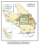
General Location
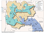
Detailed Location Map
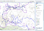
Interactive Data Map
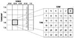
Well-Numbering System

To view PDF documents, you must have Adobe Reader installed on your computer.