Mojave Groundwater Resources
Mojave Water Studies References
Amelung, Falk, Galloway, D.L., Bell, J.W., Zebker, H.A., and Laczniak, R.J., 1999, Sensing the ups and downs of Las Vegas : InSAR reveals structural control of land subsidence and aquifer-system deformation: Geology, v. 27, no. 6, p. 483-486., https://doi.org/10.1130/0091-7613(1999)027<0483:STUADO>2.3.CO;2.
Ball, J.W., Izbicki, J.A., 2004, Occurrence of hexavalent chromium in ground water in the western Mojave Desert, California. Applied Geochemistry 19, p. 1123-1135.
Bawden, G.W., Sneed, M., Stork, S.V., and Galloway, D.L., 2003, Measuring human-induced land subsidence from space: U.S. Geological Survey Fact Sheet 069-03, 4 p., https://doi.org/10.3133/fs06903.
Bayer, B., Simoni, A., Schmidt, D., and Bertello, L., 2017, Using advanced InSAR techniques to monitor landslide deformations induced by tunneling in the Northern Apennines, Italy: Engineering Geology, v. 226, p. 20-32, http://dx.doi.org/10.1016/j.enggeo.2017.03.026.
Brandt, J. T., 2021, Interferometric Synthetic Aperture Radar Data, Mojave River and Morongo Groundwater Basins, Southwestern Mojave Desert, California, 2014-19, U.S. Geological Survey Data Release, https://doi.org/10.5066/P99OIM8N.
Brandt, J.T., and Sneed, M., 2017, Land subsidence in the southwestern Mojave Desert, California, 1992-2009: U.S. Geological Survey Fact Sheet 2017-3053, 6 p., https://doi.org/10.3133/fs20173053.
Brandt, J.T., and Sneed, M., 2021, Land Subsidence in the Mojave River and Morongo Groundwater Basins, Southwestern Mojave Desert, California, 2014-19: U.S. Geological Survey website, unpaginated, https://doi.org/10.5066/P9306T67.
Bortugno, E.J., 1986, Map showing recency of faulting, San Bernardino Quadrangle, California Division of Mines and Geology Regional Geologic Map Series, San Bernardino Quadrangle-map no. 3A, scale 1:250,000, https://www.conservation.ca.gov/cgs/Documents/Publications/Regional-Geologic-Maps/RGM_003A/RGM_003A_SanBernardino_1986_Sheet5of5.pdf
California Department of Public Health, 2010, Drinking Water Notification Levels and Response Levels: An Overview, accessed December 2, 2014, at https://www.waterboards.ca.gov/drinking_water/certlic/drinkingwater/documents/notificationlevels/notificationlevels.pdf.
California State Water Resources Control Board, 2014, California Regulations Related to Drinking Water, July 1, 2014, accessed December 2, 2014, at https://www.waterboards.ca.gov/drinkingwater/certlic/drinkingwater/documents/lawbook/dwregulations-2014-07-01.pdf.
California Department of Water Resources, 1964, Names and areal code numbers of hydrologic areas in the Southern District: California Department of Water Resources Office Report, 57 p.
California Department of Water Resources, 1967, Mojave River ground-water basins investigation: California Department of Water Resources Bulletin 84, 151 p.
California Department of Water Resources, 2003, California’s groundwater: California Department of Water Resources, Bulletin 118, Update 2003, accessed March 30, 2016, at https://www.water.ca.gov/groundwater/bulletin118/report2003.cfm.
California Department of Water Resources, 2016, California's groundwater—Working toward sustainability: California Department of Water Resources Bulletin 118 Interim Update 2016, 45 p., accessed September 21, 2021, at https://cawaterlibrary.net/document/bulletin-118-californias-groundwater-interim-update-2016/.
Christensen, A. H., Fields-Garland, L.S., 2001, Concentrations for total dissolved solids, arsenic, boron, fluoride, and nitrite-nitrate for wells sampled in the Mojave Water Agency Management Area, California, 1991-97: U.S. Geological Survey Open-File Report 2001-84, 1 CD, https://pubs.er.usgs.gov/publication/ofr0184.
Cox, B.F., and Wilshire, H.G., 1993, Geologic map of the area around the Nebo Annex, Marine Corps Logistics Base, Barstow, California: U.S. Geological Survey Open-File Report 93-568, 36 p., 1 map sheet, scale 1:12000, https://pubs.er.usgs.gov/usgspubs/ofr/ofr93568.
Cox, B.F., and Wilshire, H.G., 1994, Geologic map of the Yermo Annex and vicinity, Marine Corps Logistics base, Barstow, California: U.S. Geological Survey Open-File Report 94-681, 18 p., 1 map sheet, scale 1:12,000, https://pubs.er.usgs.gov/usgspubs/ofr/ofr94681.
Cunningham, W.L., and Schalk, C.W., comps., 2011, Groundwater technical procedures of the U.S. Geological Survey: U.S. Geological Survey Techniques and Methods 1-A1, 151 p., https://pubs.usgs.gov/tm/1a1/.
Dawson, B.J.M., and Belitz, K., 2012, Status of groundwater quality in the California Desert Region, 2006-2008: California GAMA Priority Basins Project, U.S. Geological Survey Scientific Investigations Report 2012-5040, 102 p., https://doi.org/10.3133/sir20125040.
Dick, M.C., 2017, Regional Water Table (2016) in the Mojave River and Morongo Groundwater Basins, Southwestern Mojave Desert, California: U.S. Geological Survey Data Release, https://doi.org/10.5066/F7GB2291.
Dick, M.C., and Kjos, A.R., 2017, Regional water table (2016) in the Mojave River and Morongo groundwater basins, southwestern Mojave Desert, California: U.S. Geological Survey Scientific Investigations Map 3391, scale 1:170,000, https://doi.org/10.3133/sim3391.
Dick, M.C. and Seymour, W.A., 2023, Regional Water Table (2018) in the Mojave River and Morongo Areas, Southwestern Mojave Desert, California: United States Geological Survey data release, http://doi.org/10.5066/P9BQCTHF.
Fielding, E.J., Blom, R.G., and Goldstein, R.M., 1998, Rapid subsidence over oil fields measured by SAR interferometry: Geophysical Research Letters, v. 25, p. 3215., https://www-radar.jpl.nasa.gov/s323/IntSARapps/LH-Belridge_GRL.html.
Freeze, A.R, and Cherry, J.A., 1979, Groundwater: Englewood Cliffs, New Jersey, Prentice-Hall, 604 p.
French, J.J., 1978, Ground-water storage in the Johnson Valley area, San Bernardino Country, California: U.S. Geological Survey Water-Resources Investigations Report 77-130, 35 p., https://doi.org/10.3133/wri77130.
Galloway, D.L., Jones, D.R., and Ingebritsen, S.E., 1999, Land subsidence in the United States: U.S. Geological Survey Circular 1182, 177 p., https://doi.org/10.3133/cir1182.
Galloway, D.L., Jones, D.R., and Ingebritsen, S.E., 2000, Measuring land subsidence from space: U.S. Geological Survey Fact Sheet 051-00, 4 p., https://pubs.usgs.gov/fs/fs-051-00/.
Goldstein, R.M., and Werner, C.L., 1998, Radar interferogram filtering for geophysical applications: Geophysical Research Letters, v. 25, n. 21, p. 4035-4038, https://doi.org/10.1029/1998GL900033.
Hanson, R.T., 1989, Aquifer-system compaction, Tucson Basin and Avra Valley, Arizona: U.S. Geological Survey Water-Resources Investigations Report 88-4172, 69 p., https://doi.org/10.3133/wri884172.
Hardt, W.F., 1971, Hydrologic analysis of Mojave River basin, California, using electric analog-model: U.S. Geological Survey Open-File Report, 84 p., https://doi.org/10.3133/ofr72157.
Helm, D.C., 1978, Field verification of a one-dimensional mathematical model for transient compaction and expansion of a confined aquifer system, in Verification of mathematical and physical models in hydraulic engineering: Proceedings, 26th annual Hydraulics Division specialty conference, University of Maryland, College Park, Maryland, August 9-11, 1978, American Society of Civil Engineers, New York, p. 189-196.
Helsel, D.R., 2005, Nondetects and Data Analysis: Statistics for Censored Environmental Data, John Wiley & Sons, Inc., New York, 268 p.
Helsel, D.R., and Hirsch, R.M., 2002, Statistical methods in water resources: U.S. Geological Survey Techniques of Water-Resources Investigations, book 4, chap. A3, 510 p., https://doi.org/10.3133/twri04A3.
Hoffmann, Jörn, Zebker, H.A., Galloway, D.L., and Amelung, Falk, 2001, Seasonal subsidence and rebound in Las Vegas Valley, Nevada, observed by synthetic aperture radar interferometry: Water Resources Research, v. 37, no. 6, p. 1551-1566., https://www.rsmas.miami.edu/users/famelung/Publications_files/HoffmannZebkerGallowayAmelung_WRR_2001.pdf.
Holzer, Thomas L. and Pampeyan, Earl H., 1981, Earth fissures and localized differential subsidence, Water Resources Research, v. 17, p. 223-227, http://doi.org/10.1029/WR017i001p00223.
Huff, J.A., Clark, D.A., and Martin, Peter, 2002, Lithologic and ground-water data for monitoring sites in the Mojave River and Morongo ground-water basins, San Bernardino County, California, 1992-98: U.S. Geological Survey Open-File Report 02-354, 416 p., https://pubs.usgs.gov/of/2002/ofr02354/main_text.html.
ICF International, 2013, Comprehensive Groundwater Cleanup Strategy for Historical Chromium Discharges from PG&E's Hinkley Compressor Station, San Bernardino County, Final Environmental Impact Report, Volume 2, Revised Draft EIR, May, (ICF 00122.11.) San Francisco, CA, Prepared for California Regional Water Quality Control Board, Lahontan Region, South Lake Tahoe, CA., https://www.waterboards.ca.gov/lahontan/water_issues/projects/pge/docs/feir/covertoces_ch1.pdf.
Ireland, R.L., Poland, J.F., and Riley, F.S., 1984, Land subsidence in the San Joaquin Valley, California, as of 1980, U.S. Geological Survey Professional Paper 437-I, 93 p., https://doi.org/10.3133/pp437I.
Izbicki, J.A., Ball, J.W., Bullen, T.D., Sutley, S.J., 2008. Chromium, chromium isotopes and selected trace elements, western Mojave Desert, USA. Applied Geochemistry v. 23, p. 1325-1352.
Izbicki, J.A., Bullen, T.D., Martin, P., Schroth, B., 2012, Delta chromium-53/52 isotopic composition of native and contaminated groundwater, Mojave Desert, USA. Applied Geochemistry, v. 27, p. 841-853.
Izbicki, John A., Martin, P., and Michel, R.L., 1995, Source, movement and age of groundwater in the upper part of the Mojave River Basin, California, USA. Proceedings of the 1994 International Symposium on Application of Tracers in Arid Zone Hydrology, Vienna, 22-26 August 1994., p. 43-56.
Kaab, A., Huggel, C., Fischer, L., Guex, S., Paul, F., Roer, I., Salzmann, N., Schlaefli, S., Schmutz, K., Schneider, D., Strozzi, T., and Weidmann, Y., 2005, Remote sensing of glacier- and permafrost-related hazards in high mountains: an overview: Natural Hazards and Earth System Sciences, v. 5, p. 527-554.
Kaplan, E.L., and Meier, O., 1958, Nonparametric estimation from incomplete observations, Journal of the American Statistical Association, v. 53, no. 282, 457-481.
Langbein, John, 2008, Noise in GPS displacement measurements from Southern California and Southern Nevada: Journal of Geophysical Research, v. 113, B05405, 12 p.
Lewis R.E., 1972, Ground-water resources of the Yucca Valley-Joshua Tree area, San Bernardino County, California: U.S. Geological Survey Open-File Report 72-234, 51 p., https://pubs.er.usgs.gov/publication/ofr72234.
Li, Zhen, and Martin, Peter, 2011, Geohydrology, simulation of regional groundwater flow, and assessment of water-management strategies, Twentynine Palms area, California: U.S. Geological Survey Scientific Investigations Report 2010-5249, 106 p., https://doi.org/10.3133/sir20105249.
Lines, G.C., 1996, Ground-water and surface-water relations along the Mojave River, Southern California: U.S. Geological Survey Water-Resources Investigations Report 95-4189, 43 p., https://doi.org/10.3133/wri954189.
Lohman, S.W., 1972, Definitions of selected ground-water terms—Revisions and conceptual refinements: U.S. Geological Survey Water-Supply Paper 1988, 21 p., ttps://doi.org/10.3133/wsp1988.
Londquist, C.J., and Martin, Peter, 1991, Geohydrology and ground-water-flow simulation of the Surprise Spring Basin aquifer system, San Bernardino, California: U.S. Geological Survey Water-Resources Investigations Report 89-4099, 41 p., https://doi.org/10.3133/wri894099.
Massonnet, D., Briole, P., and Arnaud, A., 1995, Deflation of Mount Etna monitored by spaceborne radar interferometry: Nature, v. 375, p. 567-570, https://www.nature.com/nature/journal/v375/n6532/abs/375567a0.html.
Massonnet, D., Holzer, T., and Vadon, H., 1997, Land subsidence caused by the East Mesa geothermal field, California, observed using SAR interferometry: Geophysical Research Letters, v. 24, p. 901-904., https://www.agu.org/pubs/crossref/1997/97GL00817.shtml.
Massonnet, D., Rossi, M., Carmona, C., Adragna, F., Peltzer, G., Feigl, K., and Rabaute, T., 1993, The displacement field of the Landers earthquake mapped by radar interferometry: Nature, v. 364, p. 138-142., https://earth.esa.int/applications/tandem/eeo3.355/0676b.html.
Mathany, T.M., and K. Belitz, 2009, Groundwater quality data in the Mojave study unit, 2008 — Results from the California GAMA program: U.S. Geological Survey Data-Series Report 440, 69 p., https://doi.org/10.3133/ds440.
McMahon, P.B., and Chapelle, F.H., 2008, Redox processes and water quality of selected principal aquifer systems: Ground Water, v. 46, no. 2, p. 259-271.
Mendez, G.O., and Christensen, A.H., 1997, Regional water table (1996) and water-level changes in the Mojave River, Morongo, and Fort Irwin ground-water basins, San Bernardino County, California: U.S. Geological Survey Water-Resources Investigations Report 97-4160, 34 p., map in pocket, https://doi.org/10.3133/wri974160.
Meinzer, O.E., 1928, Compressibility and elasticity of artesian aquifers, Economic Geology, v. 23, no. 3, p. 263-291, https://econgeol.geoscienceworld.org/cgi/content/abstract/23/3/263.
Metzger, L.F., Landon, M.K., House, S.F., and Olsen, L.D., 2015, Mapping selected trace elements and major ions, 2000-2012, Mojave River and Morongo Groundwater Basins, Southwestern Mojave Desert, San Bernardino County, California: U.S. Geological Survey Data Release, https://ca.water.usgs.gov/mojave/mojave-water-quality.html, doi:10.5066/F7Q23X95.
Mojave Basin Area Watermaster, 1995, First annual report of the Mojave Basin Area Watermaster 1993-1994, vol II, accessed November 2, 2015 at https://www.mojavewater.org/wp-content/uploads/2022/04/1ar9394.pdf.
Mojave Basin Area Watermaster, 2015, Twenty-first annual report of the Mojave Basin Area Watermaster, 2013-14, Appendix L, accessed November 2, 2015 at https://www.mojavewater.org/wp-content/uploads/2022/04/21AR1314.pdf.
Mojave Basin Area Watermaster, 2016, Twenty-third annual report of the Mojave Basin Area Watermaster, 2015-16, Appendix L, accessed April 17, 2017 at https://www.mojavewater.org/wp-content/uploads/2022/04/23AR1516.pdf.
Mojave Basin Area Watermaster, 2019, Twenty-fifth annual report of the Mojave Basin Area Watermaster, 2017-18, Appendix L, accessed December 17, 2021 at https://www.mojavewater.org/wp-content/uploads/2022/04/25AR1718_Revised.pdf.
Mojave Basin Area Watermaster, 2020, Twenty-sixth annual report of the Mojave Basin Area Watermaster, 2018-19: Mojave Basin Watermaster annual report, accessed December 17, 2021, at https://www.mojavewater.org/wp-content/uploads/2022/04/26AR1819_Revised.pdf
Mojave Basin Area Watermaster, 2021, Twenty-seventh annual report of the Mojave Basin Area Watermaster, 2019-20: Mojave Basin Watermaster annual report, accessed December 17, 2021 at https://www.mojavewater.org/wp-content/uploads/2022/04/27AR1920_Revised.pdf.
Mojave Water Agency, 2004, 2004 Regional Water Management Plan, prepared by Schlumberger Water Services, Apple Valley, California, accessed August 4, 2014 at https://www.mywaterplan.com/files/mwa-2004-rwmp.pdf.
Mojave Water Agency, 2014, Final Mojave Region Integrated Regional Water Management Plan, prepared by Kennedy/Jenks Consultants, Oxnard, California, accessed August 4, 2014 at https://www.mywaterplan.com/files/Mojave_IRWM-Plan_Final_062614.pdf.
Mojave Water Agency, 2021, Morongo Subarea Hydrographs 2021: Mojave Water Agency website accessed February 21, 2023 at https://www.mojavewater.org/wp-content/uploads/2022/08/MorongoHyd2021.pdf.
Mount, J., Escriva-Bou, A., and Sencan, B., 2021, Droughts in California: Public Policy Institute of California website, accessed December 2, 2021 at https://www.ppic.org/publication/droughts-in-california.
Moyle, W.R., Jr., 1984, Bouguer gravity anomaly map of the Twentynine Palms Marine Corps Base and vicinity, California: U.S. Geological Survey Water-Resources Investigations Report 84-4005, scale 1:65,500, 1 sheet, https://doi.org/10.3133/wri844005.
Nishikawa, T., Izbicki, J.A., Hevesi, J.A., Stamos, C.L., and Martin, P., 2004, Evaluation of geohydrologic framework, recharge estimates, and ground-water flow of the Joshua Tree area, San Bernardino County, California: U.S. Geological Survey Scientific Investigations Report 2004-5267, 115 p., https://pubs.usgs.gov/sir/2004/5267/.
Oblinger-Childress, C.J., Foreman, W.T., Connor, B.F., and Maloney, T.J., 1999, New Reporting Procedures Based on Long-Term Method Detection Levels and Some Considerations for Interpretations of Water-Quality Data Provided by the U.S. Geological Survey National Water Quality Laboratory, U.S. Geological Survey Open-File Report 99-193, 19 p., https://doi.org/10.3133/ofr99193.
Poland, J.F., ed., 1984, Guidebook to studies of land subsidence due to ground-water withdrawal, v. 40 of UNESCO Studies and Reports in Hydrology: Paris, Frane, United Nations Educational, Scientific and Cultural Organization, 305 p., 5 appendixes, https://wwwrcamnl.wr.usgs.gov/rgws/Unesco/PDF-Chapters/Title.pdf.
Rantz, S.E., 1969 (1972), Mean annual precipitation in the California region: U.S. Geological Survey Open-File Map, 5 p., (includes two sheets, scale 1:1,000,000).
Riley, F.S., 1969, Analysis of borehole extensometer data from central California, in Tison, L.J., Land subsidence: International Association of Hydrological Sciences Publication 89, v. 2, p. 423-431, https://unesdoc.unesco.org/ark:/48223/pf0000014816.
Riley, F.S., 1998, Mechanics of aquifer systems The scientific legacy of Joseph F Poland in Borchers, J.W., ed., Land subsidence case studies and current research Proceedings of the Dr Joseph F Poland Symposium on Land Subsidence: Belmont, California, Star Publishing Co., Association of Engineering Geologists Special Publication 8, p. 13-27.
Saucedo and others, 2000, Digital database of faults from the Fault Activity Map of California and Adjacent Areas: California Department of Conservation, Division of Mines and Geology, CD-ROM 2000-006.
Schaefer, D.H., 1978, Ground-water resources of the Marine Corps Base, Twentynine Palms, San Bernardino County, California, U.S. Geological Survey Water-Resources Investigations Report 77-37, 29 p., https://doi.org/10.3133/wri7737.
Schaefer, D.H., 1979, Ground-water conditions and potential for artificial recharge in Lucerne Valley, San Bernardino County, California: U.S. Geological Survey Water-Resources Investigations Report 78-118, 37 p., https://doi.org/10.3133/wri78118.
Schlumberger Water Services, 2010.
Westbay System brochure: Multi-level, Multi-parameter, Subsurface Monitoring, Houston, Texas,
accessed January 15, 2014 at https://www.swstechnology.com/pdfs/brochures/westbay_system/pdf.
Scripps Orbit and Permanent Array Center: Time Series Data, Available at: ftp://garner.ucsd.edu/pub/timeseries/measures/ats/WesternNorthAmerica/, last access: December 11, 2019.
Seymour, W.A. and Dick, M. C., 2023, Regional Water Table (2020) in the Mojave River and Morongo areas, Southwestern Mojave Desert, California: United States Geological Survey data release, http://doi.org/10.5066/P9J61E01.
Smith, G.A., 2002, Regional water table (2000) and ground-water-level changes in the Mojave River and the Morongo ground-water basins, San Bernardino County, California: U.S. Geological Survey Water-Resources Investigations Report 02-4277, https://pubs.usgs.gov/wri/wri024277/.
Smith, G.A., and Pimentel, M.I., 2000, Regional water table (1998) and ground-water-level changes in the Mojave River and the Morongo ground-water basins, San Bernardino County, California: U.S. Geological Survey Water-Resources Investigations Report 00-4090, 107 p., map in pocket, https://doi.org/10.3133/wri20004090.
Smith, G.A., Stamos, C.L., Glockhoff, C.S., House, S.F., and Clark, D.A., 2011, Regional water table (2010) in the Mojave River and Morongo groundwater basins, Southwestern Mojave Desert, California: U.S. Geological Survey Scientific Investigations Report 2011-5234, unpaginated, https://doi.org/10.3133/sir20115234.
Smith, G.A., Stamos, C.L., and Predmore, S.K., 2004, Regional water table (2002) and water-level changes in the Mojave River and the Morongo ground-water basins, Southwestern Mojave Desert, California: U.S. Geological Survey Scientific Investigations Report 04-5081, https://water.usgs.gov/pubs/sir/2004/5081/.
Sneed, M., and Galloway, D.L., 2000, Aquifer-system compaction and land subsidence: Measurements, analyses, and simulations-the Holly Site, Edwards Air Force Base, Antelope Valley, California, U.S. Geological Survey Water-Resources Investigations Report 00-4015, 65 p., https://pubs.usgs.gov/wri/2000/wri004015/.
Sneed, M., Ikehara, M.E., Stork, S.V., Amelung, F., and Galloway, D.L., 2003, Detection and Measurement of Land Subsidence Using Interferometric Synthetic Aperture Radar and Global Positioning System, San Bernardino County, Mojave Desert, California, U.S. Geological Survey Water-Resources Investigations Report 03-4015, 60 p., https://pubs.usgs.gov/wri/wri034015/.
Sneed, M., Brandt, J.T., and Solt, M., 2014, Land subsidence, groundwater levels, and geology in the Coachella Valley, California, 1993-2010: U.S. Geological Survey, Scientific Investigations Report 2014-5075, 62 p., http://dx.doi.org/10.3133/sir20145075
Sneed, M., and Brandt, J.T., 2020, Detection and measurement of land subsidence and uplift using Global Positioning System surveys and interferometric synthetic aperture radar, Coachella Valley, California, 2010-17: U.S. Geological Survey Scientific Investigations Report 2020-5093, 74 p., https://doi.org/10.3133/sir20205093.
Solt, M., and Sneed, M., 2014, Subsidence (2004-2009) in and near lakebeds of the Mojave River and Morongo groundwater basins, southwest Mojave Desert, California: U.S. Geological Survey Scientific Investigations Report 2014-5011, unpaginated, https://dx.doi.org/10.3133/sir20145011.
Stamos, C.L., Christensen, A.H., and Langenheim, V.E., 2017, Preliminary hydrogeologic assessment near the boundary of the Antelope Valley and El Mirage Valley groundwater basins, California: U.S. Geological Survey Scientific Investigations Report 2017-5065, 44 p., https://doi.org/10.3133/sir20175065.
Stamos, C.L, Glockhoff, C.S, McPherson, K.R, and Julich, R.J, 2009, Water-level and land-subsidence studies in the Mojave River and Morongo groundwater basins: U.S. Geological Survey Scientific Investigations Report 2007-5097, unpaginated, https://pubs.usgs.gov/sir/2007/5097/.
Stamos, C.L, Huff, J.A., Predmore, S.K., and Clark, D.A., 2004, Regional Water Table (2004) and water-level changes in the Mojave River and Morongo ground-water basins, southwestern Mojave Desert, California: U.S. Geological Survey Scientific Investigations Report 2004-5187, https://pubs.usgs.gov/sir/2004/5187/.
Stamos, C.L., Martin, P., Everett, R.R., and Izbicki, J.A., 2013, The effects of artificial recharge on groundwater levels and water quality in the west hydrogeologic unit of the Warren Subbasin, San Bernardino County, California: U.S. Geological Survey Scientific Investigations Report 2013-5088, 88 p., https://doi.org/10.3133/sir20135088.
Stamos, C.L., Martin, P., Nishikawa, T., and Cox, B.F., 2001, Simulation of ground-water flow in the Mojave River basin, California: U.S. Geological Survey Water-Resources Investigations Report 01-4002, 129 p., https://pubs.usgs.gov/wri/wri014002/.
Stamos, C.L., Martin, P., and Predmore, S.K., 2002, Simulation of Water-Management Alternatives in the Mojave River Ground-Water Basin, California: U.S. Geological Survey Open-File Report 02-430, 38p., https://pubs.usgs.gov/of/2002/ofr02430/.
Stamos, C.L., McPherson, K.R., Sneed, M., and Brandt, J.T., 2007, Water-Level and Land-Subsidence Studies in the Mojave River and Morongo Ground-Water Basins: U.S. Geological Survey Scientific Investigations Report 2007-5097, https://pubs.usgs.gov/sir/2007/5097/.
Stamos, C.L., and Predmore, S.K., 1995, Data and water-table map the of the Mojave River ground-water basin, San Bernardino County, California, November 1992: U.S. Geological Survey Water-Resources Investigations Report 95-4148, scale 1:125,000, 1 sheet, https://doi.org/10.3133/wri954148.
Teague, N.F., Dick, M.C., House, S.F., Clark, D.A., 2014, Regional Water Table (2012) in the Mojave River and Morongo Groundwater Basins, Southwestern Mojave Desert, California: U.S. Geological Survey Web page, https://dx.doi.org/10.5066/F7CJ8BHF.
Teague, N.F., Dick, M.C., House, S.F., Clark, D.A., 2016, Regional water table (2014) in the Mojave River and Morongo groundwater basins, southwestern Mojave Desert, California, 2016: U.S. Geological Open-File Report 2016-1105, 1 sheet, scale 1:170,000, https://dx.doi.org/10.3133/ofr20161105.
Terzaghi, Karl, 1925, Principles of soil mechanics: IV—Settlement and consolidation of clay: Engineering News-Record, v. 95, no. 3, p. 874-878.
Trayler, C.R., and Koczot, K.M., 1995, Regional water table (1994) and water-level changes in the Morongo Basin, San Bernardino County, California: U.S. Geological Survey Water-Resources Investigations Report 95-4209, scale 1:125,000, 1 sheet, https://doi.org/10.3133/wri954209.
U.S. Environmental Protection Agency, 2014, National Primary Drinking Water Regulations: List of Contaminants and their (MCLs), accessed December 2, 2014, at https://water.epa.gov/drink/contaminants/index.cfm#List.
U.S. Geological Survey, 2014, National field manual for the collection of water-quality data: U.S. Geological Survey Techniques of Water-Resources Investigations, book 9, chaps A1-A9, accessed June 27, 2014, at https://pubs.water.usgs.gov/twri9A.
U.S. Geological Survey, 2023, USGS water data for the Nation: U.S. Geological Survey National Water Information System database, accessed February 8, 2023, at https://doi.org/10.5066/F7P55KJN.
Werner C., U. Wegmüller, and T. Strozzi, 2002, Processing strategies for phase unwrapping for INSAR applications, 4th European Conference on Synthetic Aperture Radar (EUSAR), Cologne, Germany, June 4-6, 2002, Conference paper, p 353-356.
Williams, S.D.P., Bock, Y., Fang, P., Jamason, P., Nikolaidis, R.M., Prawirodirdjo, L., Miller, M., and Johnson, D.J., 2004, Error analysis of continuous GPS position time series: Journal of Geophysical Research, v. 109, B03412, 19 p.
Wright, M.T., and Belitz, K., 2010, Factors controlling the regional distribution of vanadium in groundwater, Groundwater, v. 48, no. 4, p. 515-525.
Zebker, H.A., Rosen, P.A., and Hensley, S., 1997, Atmospheric effects in interferometric synthetic aperture radar surface deformation and topographic maps, Journal of Geophysical Research, v. 102, p. 7547-7563, https://www.agu.org/pubs/abs/jb/96JB03804/96JB03804.html.
Zerbini, S., Richter, B., Negusisi, M., Romagnoli, C., Simon, D., Domenichini, F., and Schwahn, W., 2001, Height and gravity variations by continuous GPS, gravity, and environmental parameter observations in the southern Po Plain, near Bologna, Italy: Earth and Planetary Science Letters, v. 192, no. 3, p. 267-279.
Zilkoski, D.B., D'Onofrio, J.D., and Frakes, S.J., 1997, Guidelines for establishing GPS-derived ellipsoid heights (Standards: 2 cm and 5 cm), version 4.3: Silver Spring, Md, National Geodetic Survey, 10 p, 3 appendixes, https://www.ngs.noaa.gov/PUBS_LIB/DRAFTGuidelinesforEstablishingGPSderivedOrthometricHeights.pdf.
Mojave Region Maps
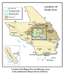
General Location
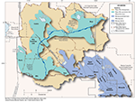
Detailed Location Map
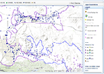
Interactive Data Map
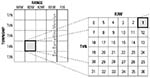
Well-Numbering System

To view PDF documents, you must have Adobe Reader installed on your computer.