San Diego Hydrogeology
Project Background
Title: Hydrogeology of the San Diego—Tijuana area, USA and Mexico
Cooperating Agencies: Sweetwater Authority, City of San Diego, Otay Water District, San Diego County Water Authority through State Bonds, and Olivenhain Municipal Water District
Projects Chief: Wes Danskin
Period of Project: Initiated in August 2001; funded through June, 2023.
Problem
No comprehensive geologic and hydrologic study has been made of the San Diego area. As a result it is difficult for state and federal agencies, water purveyors, and consultants to understand the effects of urbanization on the local surface-water, groundwater, and biologic resources or to critique ideas and opportunities for additional groundwater development. This study will provide the integrated geologic and hydrologic knowledge necessary in this important and highly visible area of the United States.
Objectives
The two primary objectives of this study are (1) to develop an integrated, comprehensive understanding of the geology and hydrology of the San Diego area, focusing on the San Diego Formation and the overlying alluvial deposits, and (2) to use this understanding to evaluate expanded use of the alluvial deposits and the San Diego Formation for recharge and extraction.
Study area map
Click on image to view PDF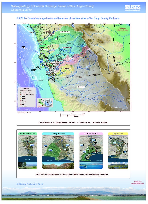
Relevance and benefits
This study will benefit local water purveyors by providing an improved understanding of the source of water to their existing production wells, and the likely effects of increased groundwater extraction. Benefits to others in the San Diego area will be from having a comprehensive investigation of the primary aquifer in the region. Benefits to the nation include quantifying the resources of an important coastal city, and developing the background information necessary to manage a complex coastal biologic-hydrologic environment.
This study addresses five issues (1, 2, 3, 8, and 9) in the USGS Strategic Directions for the Water Resources Division, 1998–2008, and addresses five issues (1, 2, 4, 5, and 6) in the more recent U.S. Geological Survey Science in the Decade 2007–2017.
Approach
To achieve the primary objectives requires (1) collection and analysis of new data, in particular new types of data such as naturally occurring stable and radioactive isotopes found in groundwater; (2) exhaustive review of existing literature and interpretative work; (3) development of comprehensive concepts that integrate geologic, hydrologic, and water-quality data; (4) testing of these concepts with a regional groundwater flow model; and (5) evaluating regional water-management questions with a simulation-optimization model. The study involves five phases with each phase focusing on a specific coastal drainage basin. Data collection and analysis are parallel between phases, but each phase can be tailored to answer specific local questions for different cooperating agencies. Phase I, which has been funded since 2001 by the Sweetwater Authority, focuses on the Sweetwater River drainage basin. Phase II, which was funded beginning in FY2008 via the Otay Water District, focuses on the Otay River drainage basin. Phase III, which has been funded since 2003 by the City of San Diego, focuses on the San Diego River drainage basin. Phase IV, which received initial funding in FY2007 from the City of San Diego, focuses on the San Dieguito River drainage basin. Phase V, which has been funded modestly via the Sweetwater Authority and City of San Diego, focuses on the Tijuana River drainage basin. Ongoing reporting of data and results is being done via a project website, presentations, and short reports. At the end of the study, a comprehensive USGS Professional Paper will summarize results for the overall study.
Progress
Since the project's inception in August 2001, the primary focus has been collection of data. More than 50 surface-water-quality samples have been taken from streams throughout the five drainage basins with the goal of identifying the interaction between surface-water and groundwater. Seven multiple-depth monitoring wells have been drilled to depths of about 1,500 feet, and two additional multiple-depth wells have been rehabilitated and sampled for water quality. About 80 groundwater-quality samples have been collected from these multiple-depth wells, as depth-dependent samples from production wells, and as bulk samples from production wells. An additional 50 groundwater-quality samples were obtained via the state-funded GAMA program. Preliminary geochemical analysis of the groundwater-quality samples is ongoing, and results were presented at a national USGS water-quality conference. A preliminary groundwater-flow model was developed for the area of phases I, II, III, and V.
Project Chief: Wes Danskin
Phone: 619-225-6132
Email: wdanskin@usgs.gov
Welcome to the United States Geological Survey (USGS) San Diego Hydrogeology (SDH) project website, which provides geologic and hydrologic information for the transboundary San Diego–Tijuana area, USA and Mexico. This website provides background information about the project; a variety of news items; a large amount of data, in particular for USGS multiple-depth, monitoring-well sites; geologic and hydrologic models; and additional resources including photos, illustrations, and references.
Last updated: July 2023.
Some additional data may be available from the USGS database National Water Information System (NWIS).
Questions about San Diego Hydrogeology? Please contact Wes Danskin (email: wdanskin@usgs.gov or send a letter). 619.225.6132