Cuyama Valley
Geologic Framework of the Cuyama Valley Groundwater Basin
An evaluation and simulation of groundwater resources are most effectively achieved through an understanding of the subsurface geologic framework through which the water moves. As a part of the overall groundwater evaluation of Cuyama Valley, scientists sought to gain a conceptual understanding of the geologic setting of the basin, and document the construction of three-dimensional digital models of the geologic framework and grain-size variations within the study area. The resulting data provide the physical geologic framework that is being used within a numerical groundwater-flow model (Randall Hansen, U.S. Geological Survey, written commun., 2013).
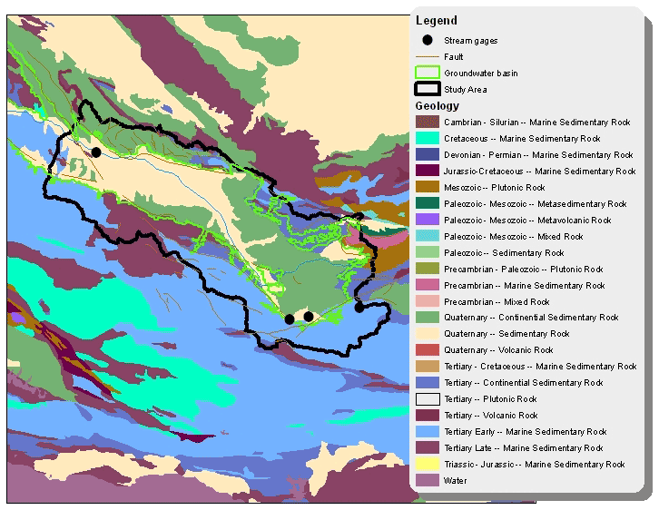
Analysis of the basin's geologic structure reveals that the valley is composed of sub-basins. Groundwater samples indicate that water does not move freely between these different formations, or between different geologic regions within the Cuyama Valley. Because of the differences in geology, hydrology and water quality, there are unique conditions and issues for each subbasin, in addition to a need for a whole-basin understanding of the system.
Geology of the Cuyama Valley
Initial Geological Analysis
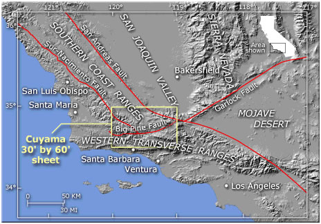
The Cuyama 30' x 60' quadrangle is in a region of major geologic structures and geologically recent to ongoing structural deformation. From Geology of the Coastal Ranges in Southern California, Geologic Framework of the Cuyama 30' x 60' Quadrangle
Previous studies of the Cuyama Valley by the USGS (Upson and Worts, 1951; Singer and Swarzenski, 1970) documented the geohydrologic conditions of the area from 1939-1966. Upson and Worts (1951) summarized existing well records, water-level fluctuations, pumpage, natural discharge, and water quality for 1939-1946. Singer and Swarzenski (1970) defined aquifers and estimated recharge, natural discharge, pumpage, and storage changes for 1947-1966. Since these studies were completed, water levels have declined into the deeper formations that were not previously investigated in detail. Because the Cuyama Valley is a sole-source aquifer, it is important to define the water-bearing and water-quality properties of the deeper stratigraphic sections of the groundwater basin.
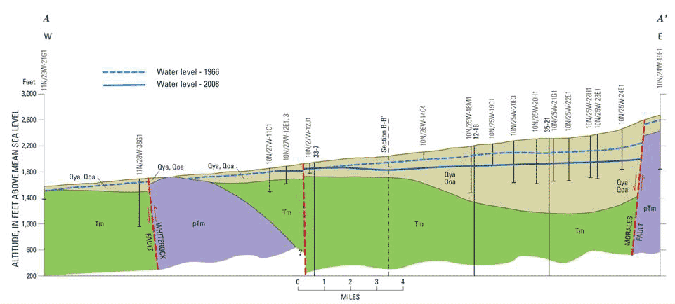
The Cuyama Valley is a downfaulted block or graben that is bordered on the north by the Morales and Whiterock faults and on the south by the South Cuyama and Ozena faults. The eastern part of the central valley is underlain by a trough-like geologic structure, or syncline, whose downward fold runs parallel to the elongation of the valley and plunges towards the northwest. The north limb of this fold is truncated against the Morales fault. Faults in the alluvium along Graveyard and Turkey Trap Ridges and at the mouth of the Santa Barbara Canyon affect the movement of groundwater.
The main water-bearing deposits in the study area are the saturated portions of the younger and older alluvium and the Morales Formation. As stated previously, all rocks that are older than the Morales Formation are considered by previous investigators to be non-water-bearing. Historically, most of the water pumped from the study area came from the younger and older alluvium. Large-capacity wells perforated in the alluvium yield 1,000-3,000 gallons per minute (gpm). Specific capacities of the alluvium range from 100 to 200 gpm per foot.
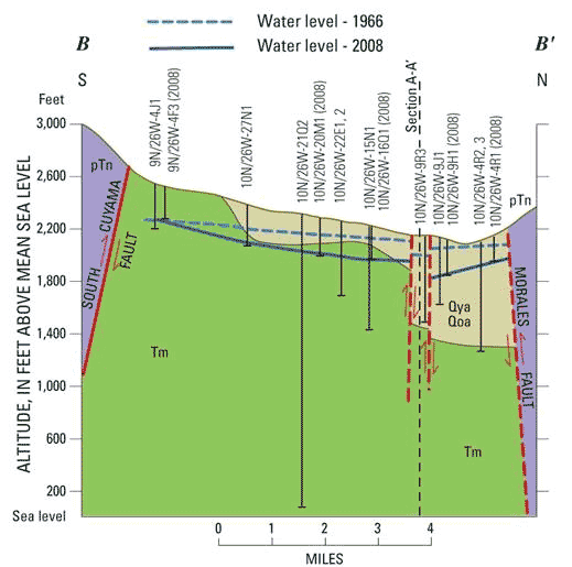
North-South Profile
East-West Profile
North-South and East-West Profiles modified from Singer and Swarinski, 1970
The water-bearing properties of the Morales Formation are not well defined, but available data shows that the hydraulic conductivity of the formation varies greatly both spatially and with depth. Wells perforated in the Morales Formation in the western part of the valley have specific capacities of 5 to 25 gpm per foot; whereas, wells perforated along the northern margin of the central valley have specific capacities of 25-50 gpm per foot. Inspection of available geologic and geophysical logs suggest that the hydraulic conductivity of the Morales Formation decreases with depth.
New Geological Findings
Previous work has outlined the overall shape of the basin, located many of the faults, and defined and characterized aquifers that historically have yielded most of the water pumped in the study area. This study builds on that work by creating three-dimensional digital datasets suitable for incorporation within a numerical groundwater-flow model and includes greater detail for the deeper stratigraphic units of the groundwater basin, which were not previously investigated in detail.
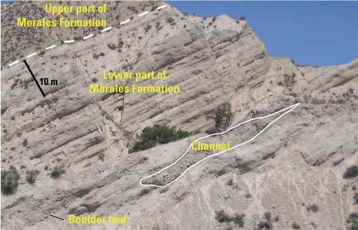
Morales Formation in the Quatal Canyon of Cuyama Valley, California.
A several hundred meter-thick section of Pliocene continental deposits and Pleistocene alluvial sediments constitutes the principal groundwater aquifer of the Cuyama Valley groundwater basin. This section can be subdivided into three principal stratigraphic units: Qya, younger alluvium; Qoa, older alluvium; and QTm, the Morales Formation. The two alluvial units are distinguished on the basis of degree of cementation and the amount of dissection and deformation. The QTm is an alluvial and fluvial deposit characterized by relatively fine-grain size, general lack of coarse channel deposits, and greater amounts of clay compared to the overlying section. Consolidated rocks that lie beneath the Morales Formation are generally non-water bearing.
The Geological Framework Model
A geologic framework model was constructed to represent the subsurface geometry of the stratigraphic units, Qya (younger alluvium), Qoa (older alluvium), QTm (the Morales Formation), and a composite pre-QTm bedrock unit, by extracting and combining information from a variety of datasets, including existing lithologic and electrical geophysical logs from oil and gas wells and water wells, cross sections, and geologic maps. The framework model was constructed by creating gridded surfaces that represented the altitude of the top of each stratigraphic unit from the input data and then combining these surfaces within a three-dimensional geologic modeling software package. In order to better characterize the aquifer-system deposits, lithologic data were compiled from approximately 235 oil and gas and water wells in the study area. Sediment grain size was interpreted for subsurface intervals ranging in depth from 12 to 1,637 ft below land surface. These data were used to create a two-dimensional (2D) texture model for each aquifer suitable for use in an integrated hydrologic flow model.
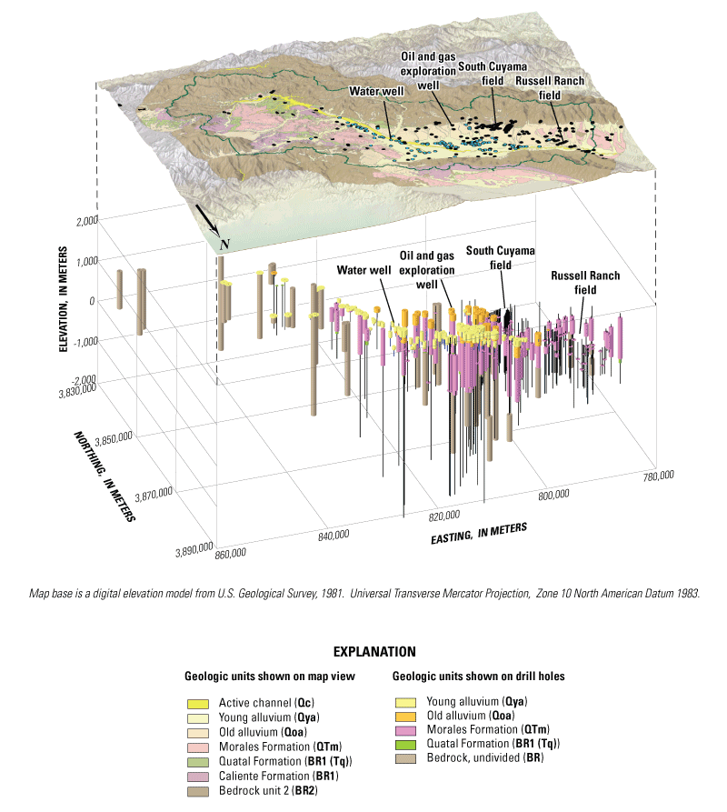
Colored cylinders represent stratigraphic units intercepted downhole in oil and gas exploration holes and water wells. Thin vertical lines represent parts of the borehole where stratigraphy was not interpreted. Colors appear variable due to the effects of illumination from below and southeast. View is from the northeast (020 degrees) looking to the southwest from an elevation of 30 degrees above the horizon. Map vertical exaggeration is 2X; wells have a vertical exaggeration of 8X. Horizonal and vertical scale is variable due to the effects of perspective view.
Cooperators
Prepared in cooperation with Santa Barbara County Water Agency
![]()
Publications
- Hanson, R.T., Flint, L.E., Faunt, C.C., Gibbs, D.R., and Schmid, W., 2014,
- Hydrologic models and analysis of water availability in Cuyama Valley, California: U.S Geological Survey Scientific Investigations Report 2014-5150, 150 p., http://dx.doi.org/10.3133/sir20145150.
- Hanson, Randall T., and Sweetkind, Donald, 2014,
- Cuyama Valley, California hydrologic study—An assessment of water availability: U.S. Geological Survey Fact Sheet 2014-3075, 4 p., http://dx.doi.org/10.3133/fs20143075.
Contacts
Claudia C. Faunt, Ph.D., P.E.
Program Chief, Groundwater Availability and Use Assessments
U.S. Geological Survey
California Water Science Center
4165 Spruance Road, Suite 200
San Diego, CA 92101
619.225.6100
ccfaunt@usgs.gov
Matthew Scrudato
Senior Hydrologist
Santa Barbara County Public Works Department
620 West Foster Road
Santa Maria, CA 93455
mscruda@cosbpw.net