California's Central Valley


The Central Valley: San Joaquin Basin

Map of the San Joaquin Valley

Population

The total population of the San Joaquin Basin in 2000 was approximately 2 million (Great Valley Center, 2005).

Major Cities

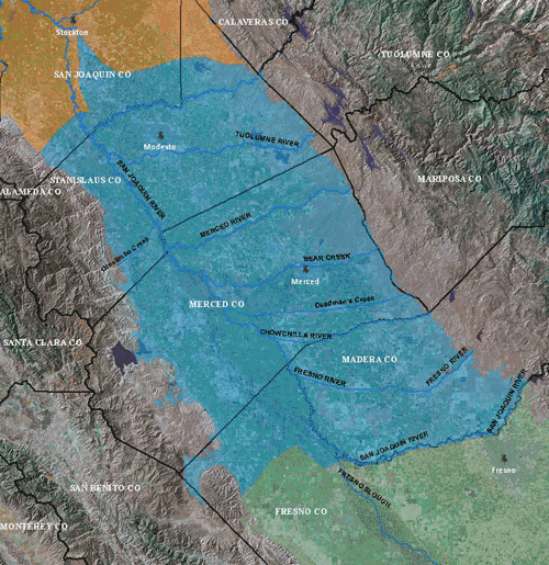
Stockton, Turlock, Merced, and Modesto

Geographic Features

San Joaquin, Stanislaus, Tuolumne, and Merced Rivers, and the southern part of the Delta

Climate

The San Joaquin Basin has mild winters and particularly hot and dry summers.

Land Use

A large part of the population of the basin is involved in all facets of agricultural production. Gradually, the population is shifting towards supporting the large urban areas and industry.

In 2000, approximately 2/3 of the area was used for agriculture. The southwestern half of the San Joaquin Basin has long been known for its cotton fields, but recent drops in cotton prices have caused a rapid shift to other crops, particularly almond orchards. On the eastern side of the San Joaquin Basin, alluvial fans are dominated by deciduous fruit and nut orchards. The remainder of the irrigated area is covered by pasture, truck, and field crops.

Water Use

Although surface water is used when it is available, the region relies heavily on groundwater. Groundwater accounts for about 30% of the annual supply of both types of water used for agricultural and urban purposes (California Department of Water Resources, 2003; Chapter C).Only about 8% of the historic San Joaquin Valley wetland acreage remains today (Moore and others, 1990).

The Central Valley

Delta & Eastside Streams

Sacramento Valley

San Joaquin Basin

Tulare Basin


San Joaquin County Groundwater Basin Studies

Public Workshop

Implications for water quality & groundwater recharge

Movement of recharge water from land surface to wells

Chloride mapping on the basis of electromagnetic log data

Assessment of Water Quality in the Northern San Joaquin Basin

Central Valley Hydrologic Model (CVHM)

Development of Hydrologic Model of Modesto Region

Land Subsidence along the Delta-Mendota Canal in the Northern Part of the Joaquin Valley, California

Land Subsidence along the Delta-Mendota Canal in the Northern Part of the Joaquin Valley, California

Groundwater Flow Model for Evaluation of Hydrologic Effects of the San Joaquin River Restoration


Valley Facts

  • More than 250 different crops are grown in the Central Valley with an estimated value of $17 billion per year
  • Approximately 75% of the irrigated land in California and 17% of the Nation's irrigated land is in the Central Valley
  • Using fewer than 1% of U.S. farmland, the Central Valley supplies 8% of U.S. agricultural output (by value) and produces 1/4 of the Nation's food, including 40% of the Nation's fruits, nuts, and other table foods.
  • The predominate crop types are cereal grains, hay, cotton, tomatoes, vegetables, citrus, tree fruits, nuts, table grapes, and wine grapes.
  • About 20% of the Nation's groundwater demand is supplied from pumping Central Valley aquifers, making it the second-most-pumped aquifer system in the U.S.
  • The Central Valley is one of the more notable structural depressions in the world.