California's Central Valley
Central Valley Hydrologic Model: Numerical Model
The CVHM encompasses the alluvial deposits of the entire Central Valley extending from the Cascade Ranges on the north to the Tehachapi Mountains on the south and bounded on the east by the Sierra Nevada and on the west by the Coast Ranges. The only outlet is through Carquinez Strait, a narrow tidal strait that is part of the tidal estuary of the Delta of the Sacramento and San Joaquin Rivers.
Spatial Discretization and Layering
To create enough detail to be practical for water-management decisions, the aquifer was divided spatially into 20,000 model cells. The model has a uniform horizontal discretization of 1 x 1 mile and is oriented parallel to the valley axis, 34 degrees west of north.
The CVHM comprises 10 layers that generally thicken with depth. The top layer (layer 1) has an upper altitude of land surface and a base equal to 50 ft below land surface. Except where the Corcoran Clay Member of the Tulare Formation (hereafter referred to as the Corcoran Clay) exists, the layers range in thickness from 50 to 400 ft, increasing by 50 ft with each progressively deeper layer. Where the Corcoran Clay exists, the layers were morphed to explicitly represent the clay with layers 4 and 5.The layering for the texture model and the flow model are the same.
For the CVHM, the bottom of the model was specified on the basis of well-completion records to incorporate the part of the aquifer system that is stressed by pumpage. The model bottom extends to 1,800 ft below land surface, and where the Corcoran Clay is present, to 1,500 ft below the Corcoran Clay. For the most part, saline water is deeper than the model bottom and may be as much as 2,500 ft deep (Berkstresser, 1973; Planert and Williams, 1995). The deeper wells are simulated in model cells where wells are perforated and presumably freshwater is present.
Temporal Discretization
The CVHM is discretized into stress periods and time steps. In order to represent the growing season adequately, the annual hydrologic cycle was divided into 12 monthly stress periods. Specified inflows and outflows, including pumpage, precipitation, evapotranspiration (ET), surface-water diversions, and water deliveries are constant within each stress period. Variations in stresses are simulated by changing stresses from one stress period to the next. Stress periods were further divided into two time steps for which water levels and flows were calculated.
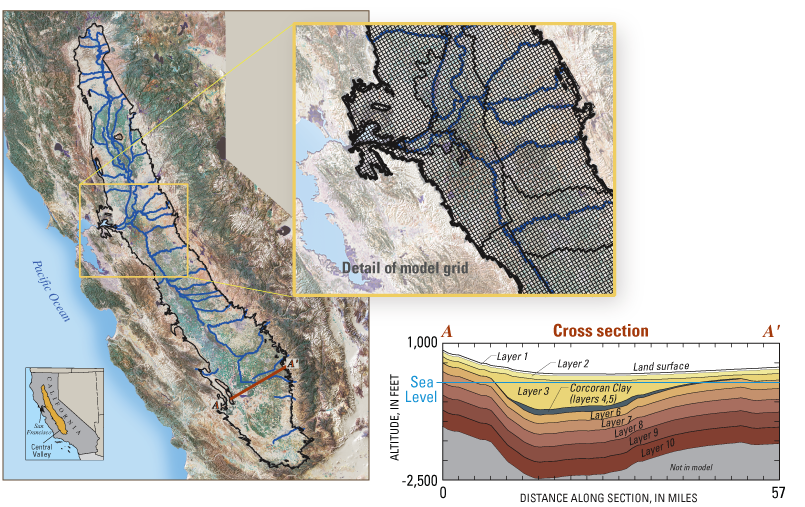
The aquifer was divided spatially into 20,000 model cells of 1 square mile each, and vertically into ten layers ranging in thickness from 50 to 750 feet.
Generalized hydrogeologic section (A - A') indicating the vertical discretization of the numerical model of the groundwater-flow system in the Central Valley, California. Line of section shown on map above (altitudes are along row 355; layer numbers indicate model layer).
Learn More about the CVHM
Contacts
Project Chief: Claudia Faunt
Phone: 619.225.6142
Email: ccfaunt@usgs.gov
Data
 Model Datasets:
- Central Valley Spatial Database (Raw Data)
- Central Valley Hydrologic Model Database (Processed Data) ZIP (52.8 MB)
 Numerical Model Data files:
 Texture Model Data files:
Publications
Water availability and land subsidence in the Central Valley, California, USA
Hydrology Journal, November, 2015
Water Availability and Subsidence in California's Central Valley
San Francisco Estuary & Watershed, September, 2015
California's Central Valley Groundwater Study: A Powerful New Tool to Assess Water Resources in California's Central Valley
U.S. Geological Survey Fact Sheet 2009-3057
Groundwater Availability of the Central Valley Aquifer, California
U.S. Geological Survey Professional Paper 1766
Development of a three-dimensional model of sedimentary texture in valley-fill deposits of Central Valley, CA, USA
Hydrogeology Journal (2010) 18: 625-649
The Farm Process Version 2 (FMP2) for MODFLOW-2005 - Modifications and Upgrades to FMP1
U.S. Geological Survey Techniques and Methods 6-A-32