California's Central Valley
Central Valley Hydrologic Model (CVHM)
In an effort to aid water managers in understanding how water moves through the aquifer system, predicting water-supply scenarios, and addressing issues related to water competition, the USGS developed a new hydrologic modeling tool, the Central Valley Hydrologic Model (CVHM). The CVHM is an extensive, detailed three-dimensional (3D) computer model of the hydrologic system of the Central Valley (Faunt, 2009). The Central Valley Hydrologic Model (CVHM) simultaneously accounts for changing water supply and demand across the landscape, and simulates surface water and groundwater flow across the entire Central Valley.
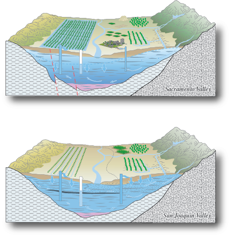
Post-development hydrogeology of the Sacramento and San Joaquin Valleys, California.
Benefits to California Water Managers
The CVHM helps to address water competition issues such as:
- Conjunctive water use (interdependent use of surface water and groundwater)
- Conservation of agricultural land
- Land-use change, including environmental concerns and urbanization, and its effects on water resources
- Effects of climate change
CVHM Components
Geospatial Database
A Geographic Information System (GIS) was used to compile, manage, store, and analyze the large quantities of data in the geospatial database needed to run the model, and to understand and visualize the data output.
Get the DataTexture Model
The texture model is key to understanding how water moves through the Central Valley groundwater system. Scientists developed the geologic texture model to describe the coarseness or fineness of valley-fill materials that make up the aquifer system, and then used it to estimate hydraulic properties for every cell in the model grid. To create the model, lithologic data from approximately 8,500 drillers' logs of boreholes ranging in depth from 12 to 3,000 feet below land surface, along with other information, were compiled and analyzed.
Texture Model DetailsFarm Process
The complex hydrologic system of the Central Valley is simulated using the USGS hydrologic modeling software, MODFLOW. Combined with the Farm Process, MODFLOW simulates natural and human-induced water movement and consumption over the landscape and accounts for supply-constrained and demand-driven conjunctive use of surface and groundwater in agricultural, urban, and natural settings. For the Central Valley, the tool simulates unmetered historical pumping and surface-water deliveries for 21 water-balance regions for water years 1962 to 2003.
Learn MoreNumerical Model
A numerical groundwater-flow model capable of being accurate at scales relevant to water-management decisions was developed for the Central Valley, California.
Learn MoreLearn More about the CVHM
Contacts
Project Chief: Claudia Faunt
Phone: 619.225.6142
Email: ccfaunt@usgs.gov
Data
 Model Datasets:
- Central Valley Spatial Database (Raw Data)
- Central Valley Hydrologic Model Database (Processed Data) ZIP (52.8 MB)
 Numerical Model Data files:
 Texture Model Data files:
Publications
Water availability and land subsidence in the Central Valley, California, USA
Hydrology Journal, November, 2015
Water Availability and Subsidence in California's Central Valley
San Francisco Estuary & Watershed, September, 2015
California's Central Valley Groundwater Study: A Powerful New Tool to Assess Water Resources in California's Central Valley
U.S. Geological Survey Fact Sheet 2009-3057
Groundwater Availability of the Central Valley Aquifer, California
U.S. Geological Survey Professional Paper 1766
Development of a three-dimensional model of sedimentary texture in valley-fill deposits of Central Valley, CA, USA
Hydrogeology Journal (2010) 18: 625-649
The Farm Process Version 2 (FMP2) for MODFLOW-2005 - Modifications and Upgrades to FMP1
U.S. Geological Survey Techniques and Methods 6-A-32