California's Central Valley
California Aqueduct: Evaluation of Groundwater Conditions and Land Subsidence Along the California Aqueduct
Groundwater and the California Aqueduct
Click to enlarge
There are concerns that fluctuating land-surface elevations due to subsidence and uplift in the valley could cause serious operational-maintenance and design construction problems for the California Aqueduct surface-water delivery system. As a result, the USGS has undertaken this study to develop a greater understanding of the location, extent, and magnitude of subsidence along the California Aqueduct, as well as to help understand the relationship of groundwater levels and land subsidence. By providing new tools to better understand the availability and sustainability of water resources, this study will aid State Water Contractors in better managing water resources, minimizing the impacts of land subsidence, and efficiently managing the California water conveyance systems.
Land Subsidence Along the California Aqueduct
Background
The San Joaquin Valley is one of the most productive agricultural regions in the nation. Beginning around the 1920's farmers relied upon groundwater for water supply. Over time, overpumping caused groundwater-level declines and associated aquifer-system compaction and land subsidence that resulted in permanent aquifer-system storage loss. By 1970, significant land subsidence (more than one foot) had occurred in about half of the San Joaquin Valley, or about 5,200 square miles (Poland and others, 1975), and locally, some areas had subsided by as much as 28 feet.
Surface-water imports via the California Aqueduct in the late 1960's and early 1970's, and the associated decrease in groundwater pumping, resulted in a steady recovery of water levels and a reduced rate of compaction. During the droughts of 1976-77, 1987-92, and 2007-09, diminished deliveries of imported water prompted increased groundwater pumping to meet irrigation demands. This increased pumping resulted in water-level declines reaching near historic lows and periods of renewed compaction. Following each of these droughts, recovery to pre-drought water levels was rapid and compaction virtually ceased.
Land Subsidence
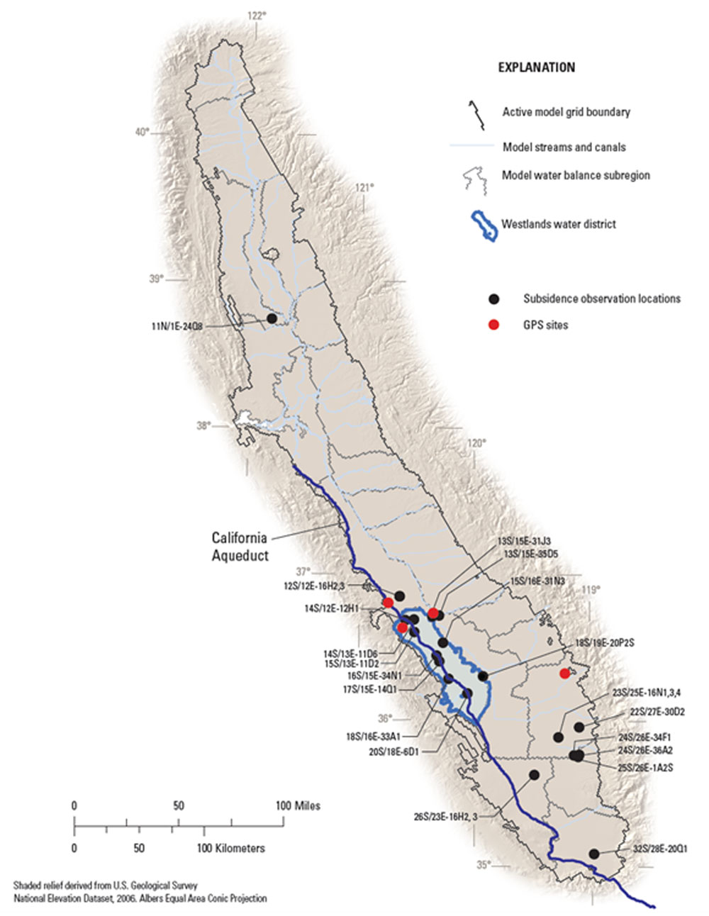
Historically, land subsidence in the San Joaquin Valley has been measured by repeat land surveys and by recording compaction at extensometers at specific locations in the valley over time. Recently, several continuously measured Global Positioning System (GPS) sites have been installed in the valley that provide a continuous measurement of land subsidence at specific locations (see map above). Each of these techniques is relatively expensive and does not provide detailed spatial resolution of the extent and magnitude of land subsidence. GPS surveying could be used to measure the areal distribution of land subsidence; however, the technique relies on field surveys that are time consuming and expensive.
InSAR methods can provide spatially detailed maps (interferograms) of changes in land-surface elevations. The resolution of the vertical displacement of land surface measurable by InSAR techniques can be as high as about 5 mm; whereas, the expected vertical resolution of geodetic surveying techniques is lower, about 20 mm or more. The spatial resolution of InSAR is orders of magnitude higher than any economical terrestrial methods. However, results of previous studies indicate that conventional InSAR methods are not ideal for large areas of the valley because agricultural land use disturbs the ground surface and causes decorrelation of the processed image, which cannot be readily interpreted (Brandt and others, 2005). However, the more recently-developed persistent scatterer technique may improve the results in these areas. The persistent scatterer InSAR technique algorithmically detects and selects points or targets (persistent scatterers) based on spectral and intensity properties, then computes interferograms for those points only, which greatly reduces decorrelation (Werner and others, 2003; Hoffmann and others, 2005; Strozz and others, 2005). If enough persistent scatterers, such as buildings, roads, and other structures are identified, this technique may enable detection and measurement of land subsidence for the considerably large study area. For such large areas, using other techniques to measure land subsidence, such as spirit leveling or GPS would be prohibitively expensive, and would not provide the spatial or temporal detail possible with InSAR. The persistent scatterer technique may provide a temporally and spatially dense time series of land subsidence for periods during 2003-10. This new monitoring method may provide managers with the subsidence information needed to manage the water conveyance systems.
Relationship of Groundwater Levels and Land Subsidence
Groundwater-level data for 2003-10 was obtained from the California Department of Water Resources (DWR), Westlands Water District and USGS databases to assess the relationship of groundwater levels to land-surface-elevation changes for 2003-10. Locations of wells will be compared to locations of subsidence and changes in groundwater levels will be compared with changes in land-surface elevations.
Two continuous GPS sites are currently in operation in the northern part of the Westlands area (see map above). Data from these continuous GPS sites will provide information on the time history of land-surface elevation change. A continuously operating pressure transducer was installed in an existing well near one of the continuous GPS sites to provide information on water-level changes near a known area of subsidence. The continuous GPS and water-level data can then be used for stress-strain analysis (subject to data availability). If water levels fluctuate in the elastic range of stress, the elastic storage coefficient will be computed. The elastic storage coefficient is a standard measure of aquifer storage and governs the recoverable (reversible) deformation of the aquifer system. If water levels continue to decline beyond historically low levels (the inelastic range of stress), it may be possible to compute the inelastic storage coefficient that governs the persistent compaction of the aquifer system. If water levels are fluctuating in both ranges of stress (fluctuating seasonally and declining annually), both the elastic and inelastic storage coefficients could be computed. All water-level data collected for this study will be stored in the USGS database (National Water Information System).
Publications
- Sneed, M., Brandt, J., Solt, M., 2013
- Land Subsidence along the Delta-Mendota Canal in the Northern Part of the San Joaquin Valley, California, 2003-10: U.S. Geological Survey Scientific Investigations Report 2013-5142, 87 p.
- Faunt, Claudia C. (editor), 2009,
- Groundwater Availability of the Central Valley Aquifer, California: U.S. Geological Survey Professional Paper 1766, 227 p.
Contacts
Project Chief Michelle Sneed
Phone 916.278.3000
Email micsneed@usgs.gov
Cooperators
California Department of Water Resources
State Water Contractors