Mojave Groundwater Resources
1994 Mojave Region Water-Level Study
Groundwater Levels
Static water-level measurements collected during January-October 1994 by the U.S. Geological Survey (USGS) and other agencies from about 260 wells were used to construct a regional water-table map, which shows the altitude of the water table and general direction of groundwater movement in the Morongo groundwater basin. Additional water-level data (from 11 wells) collected prior to 1994 also were used to construct the map where current data could not be obtained or in areas of sparse data and little water-level fluctuation. In addition to being available on the interactive map, the 1994 water-level data and contours are shown on a PDF formatted plate. Historical water-level data were used in conjunction with data collected from this study to construct 21 water-level hydrographs to show long-term (as early as 1940) water-level changes in different parts of the basin.
Water-Level Changes
Available data for wells in the Morongo Basin were evaluated to determine water-level changes in different parts of the basin. Twenty-one long-term hydrographs for selected wells are shown on the large map (PDF formatted plate, hydrographs). Water levels have remained relatively constant in the Deadman, Emerson, Mesquite, Mainside, Copper Mountain, Johnson, Upper Johnson, and Fry Basin (location map), where the resident population is small and pumpage is minimal or nonexistent. Available data were insufficient to determine fluctuations of the water table in the Pipes, Emerson, or Giant Rock Basins. Water-table declines have occurred in parts of the Reche, Joshua Tree, Twenty-nine Palms, Surprise Spring, and Warren Basins. In the Reche Basin, the water levels has declined about 36 ft since 1963 at well 2N/6E-18B1, probably the result of pumpage to supply the town of Landers; in the Joshua Tree and Twentynine Palms Basins, pumpage to supply the towns of Joshua Tree and Twentynine Palms has caused declines of about 25 ft since 1963 at well 1N/7E-32C1, and about 54 ft since 1940 at well 1N/8E-36A1; in the Surprise Spring Basin, the water levels had declined 110 ft since 1960 at well 2N/7E-2C1 as a result of pumpage for the USMCAGCC; and in the Lucerne Basin, the water levels has declined as much as 94 ft since 1954 at well 5N/1E-17D1, near the town of Lucerne Valley (location map).
The largest observed water-level decline in the study area is in the Warren Basin, at Yucca Valley, where the combined decline since 1947 is 309 ft at well 1N/5E-36K1 (destroyed) and nearby well 1N/5E-36K2 (combined hydrograph ). The data for these two wells were combined to give a better indication of total decline in this area. In the western part of Warren Basin, the decline at well 1N/5E-34N1 is about 178 ft since 1958. These large declines probably result from increased pumpage to supply the growing population of Yucca Valley. The magnitude of those declines indicates small storage in compartments of the aquifer that are bounded by faults in combination with minimal natural recharge.
Mojave Region Maps
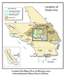
General Location
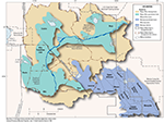
Detailed Location Map
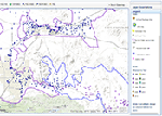
Interactive Data Map
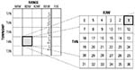
Well-Numbering System

To view PDF documents, you must have Adobe Reader installed on your computer.