Mojave Groundwater Resources
1992 Mojave Region Water-Level Study
Groundwater Levels
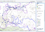
Static water-level measurements collected during mostly during November 1992 by the U.S. Geological Survey (USGS) and local water districts from about 470 wells were used to construct a regional water-table map, which shows the altitude of the water table and general direction of groundwater movement in the Mojave River groundwater basin. Water levels in some areas of the regional aquifer were measured outside this time period in order to substantiate existing data, and to supply data where November 1992 measurements were lacking. These measurements (made during 1991-94) were considered appropriate for use in constructing the map because they are from areas of the regional aquifer where pumping is minimal and water levels are relatively static on a yearly basis. In addition to being available on the interactive map, the 1992 water-level data and contours are shown on a PDF formatted plate.
Water-Level Changes
Pumping also has affected the shape and gradient of the water table over time. The rapid development of the Upper Mojave River Basin—which includes the communities of Hesperia, Apple Valley, and Adelanto—and the subsequent demand for water have caused significant water-level declines. In comparison with 1964 water-level data reported by the California Department of Water Resources (1967), water levels have declined more that 50 ft in some parts of Apple Valley. A large cone of depression, caused by the removal of ground water from aquifer storage, has developed near the city of Adelanto, although suspected subsurface faults also may be affecting the water table. Additional data are needed to better understand the factors affecting groundwater flow in this region. Other areas of large water-level declines since 1964 include the region southeast of the Calico-Newberry Fault in the Baja subbasin, where water level-declines range from 30 to 50 ft (California Department of Water Resources, 1967).
Mojave Region Maps
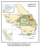
General Location
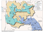
Detailed Location Map
Interactive Data Map
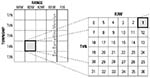
Well-Numbering System

To view PDF documents, you must have Adobe Reader installed on your computer.