By Steven K. Predmore, Kathryn M. Koczot, and Katherine S. Paybins
U.S. Geological Survey Open-File Report 96-629
This section contains well information, which includes information on construction, water quality, water level, pumpage, and location.
CONSTRUCTION

Description:        Well-construction information.

Data type:          DATA TABLE.

Source:             Modified from:
                    (a) Ventura County, Department of Public Works, 1991a,
                    Untitled: Digital data files of well construction
                    information: Ventura County, Calif. (on file with the
                    Department of Public works).

                    (b) U.S. Geological Survey, (ongoing), National Water
                    Information System (Digital data available from the U.S.
                    Geological Survey, 5735 Kearny Villa Road Suite O, San
                    Diego, CA 92123).

                    (c) California Department of Public Works, 1933, Ventura
                    County investigation: California Department of Public
                    Works, Division of Water Resources Bulletin No. 46,
                    244 p., pl. B and XLIX.

Method of entry:    Data were obtained as text files, formatted to meet the
                    data-base input requirements, and imported into a data
                    table.

Quality control:    Information in the data table was verified with the
                    original text files. Erroneous values were identified and
                    corrected.

Final update:       November 30, 1993

Description
of variables:       CONSTRUCTION data table.


Variable     Type        Length  Definition

WELLID       Character   12      Identification number.
BASIN        Character   5       California Department of Public Works subarea code.
QUAD         Character   4       Name of U.S. Geological Survey 7.5-minute
                                 topographic quadrangle in which the well is
                                 located.
PERMIT#      Character   4       Ventura County drilling permit number.
DRILLER      Character   20      Name of the drilling company.
DATE         Character   5       Month and year the well was drilled.
YEAR         Integer     2       The year the well was drilled.
LSE_ACCUR    Character   1       Identifies land-surface elevation as surveyed
                                 or taken from U.S. Geological Survey
                                 7.5-minute topographic quadrangle maps.
LSE          Floating    7       Land-surface elevation, in feet above sea
               decimal           level.
RP_ACCUR     Character   1       Measuring point accuracy.
RP           Floating    7       Measuring point elevation, in feet above sea
               decimal           level.
DEPTH        Integer     5       Depth the well was drilled, in feet below sea
                                 level.
WELL_DIAM    Character   2       Diameter of hole, in inches.
CASING_DEPTH Integer     4       Casing depth, in feet.

CASING_DIAM  Character   4       Casing diameter, in inches.
TOP          Integer     4       Depth to top of screen interval, in feet.
BOP          Integer     4       Depth to bottom of screen, in feet.
DRAWDOWN     Floating    5       Drawdown from pump tests, in feet.
               decimal
LOG          Character   8       Type of drilling log.
AQUIF_DESIG  Character   12      Aquifer where well is screened.
WELL_USE     Character   12      Use classification.
CONDITION    Character   12      Condition classification.
GPM          Floating    6       Production rate, in gallons per minute.
               decimal
SPEC_CAP     Floating    7       Specific capacity, in gallons per minute per
               decimal           foot of draw down.
Description:        Water-quality measurements for wells in the Santa
                    Clara-Calleguas drainage basin,1923 to December 1995.

Data type:          DATA TABLE.

Source:             Modified from:
                    (a) Ventura County Department of Public Works, 1994c,
                    Untitled: Digital data files of water-quality information
                    for 1989 to 1994: Ventura County, Calif. (on file with
                    the Department of Public works).

                    (b) U.S. Geological Survey, (ongoing), National Water
                    Information System (Digital data available from the U.S.
                    Geological Survey, 5735 Kearny Villa Road Suite O, San
                    Diego, CA 92123).

Method of entry:    Water-quality data were obtained as text files,
                    formatted to meet the data-base input requirements, and
                    imported into a data table.

Quality control:    Information in the data table was verified with the
                    original text files. Erroneous values were identified and
                    corrected.

Final update:       December 1995

Description
of variables:       QW.MASTER data table.


Variable     Type       Length  Definition

WELLID       Character  12      Identification number.
DATE         Date       8       Date sample collected.
TIME         Integer    4       Time collected.
TEMPERATURE  Numeric    5       Water temperature of sample, in degrees Fahrenheit.
BASIN        Character  5       California Department of Water Resources identification
                                number of hydrologic subunits.
NAME         Character  30      Name of hydrologic subunit in which the well is located.
SO4          Numeric    7       Sulphate, in milligram per liter (mg/L).
CL           Numeric    7       Chloride, in mg/L.
DBASE        Integer    2       Identifies the original data source.
Description:        Water-level records for wells in the Santa Clara-Calleguas
                    drainage basin, 1912 to December 1995.

Data type:          DATA TABLE.

Source:             Modified from:
                    (a) Ventura County, Department of Public Works, 1994b,
                    Untitled: Digital data files of water-level data for 1989
                    to 1994: Ventura County, Calif. (on file with the
                    Department of Public works).

                    (b) U.S. Geological Survey, (ongoing), National Water
                    Information System (Digital data available from the U.S.
                    Geological Survey, 5735 Kearny Villa Road Suite O, San
                    Diego, CA 92123).

Method of entry:    Water-level data were obtained as text files, formatted to
                    meet the data-base input requirements, and imported into a
                    data table.

Quality control:    Information in the data table was verified with the
                    original text files. Erroneous values were identified and
                    corrected.

Final update:       December 1995

Description
of variables:       MASTER.WL data table.


Variable  Type       Length  Definition

WELLID    Character  12      Identification number.
DATE      Integer    8       Date of water-level measurement.
WSE       Numeric    6       Water-surface elevation, in feet above sea level.
DBS       Numeric    6       Depth of water level below land surface, in feet.
NAME_7.5  Character  30      Name of U.S. Geological Survey 7.5-minute
                             topographic quadrangle in which the well is
                             located.
Description:        Selected reported pumpage for wells in the Santa
                    Clara-Calleguas drainage basin, 1979 to December 1995.

Data type:          DATA TABLE.

Source:             Modified from:
                    (a) United Water Conservation District, 1994, Untitled:
                    Digital data files of pumpage data for 1989 to 1995.
                    Ventura County, Calif., (on file with United Water
                    Conservation District).

                    (b) Ventura County, Department of Public Works, 1989,
                    Untitled: Digital data file of pumpage: Ventura County,
                    Calif. (on file with the Department of Public works).

                    (c) Groundwater Management Agency, 1992, Untitled: Digital
                    data files of pumpage data: Ventura, Calif. (on file with
                    the Groundwater Management Agency).

Method of entry:    Pumpage data were obtained as text files, formatted to meet
                    the data base input requirements, and imported into a data
                    table.

Quality control:    Information in the data table was verified with the
                    original text files. Erroneous values were identified and
                    corrected.

Final update:       December 1995

Description
of variables:       PUMP.ALL data table.


Variable        Type       Length  Definition

WELLID          Character  12      Identification number.
YEAR            Integer    2       Year.
REPT_PERIOD     Integer    1       Identifies reporting period as first half of
                                   year (1) or second half of year (2).
EXTRACT_AG      Floating   10      Pumpage for agricultural use, in acre-feet.
                  decimal
EXTRACT_NON_AG  Floating   10      Pumpage for nonagricultural use, in acre-feet.
                  decimal
EXTRACT         Floating   10      Total pumpage, in acre-feet.
                  decimal
SOURCE          Character  8       Source.
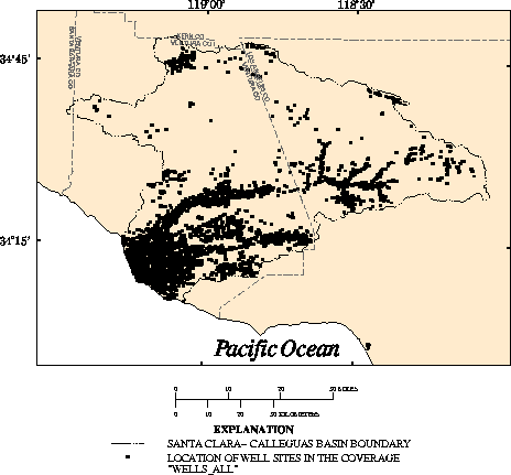
Description:        Wells used in Regional Aquifer-System Analysis study.

Data type:          POINT.

Source:             Modified from:
                    (a) California Department of Water Resources, (ongoing),
                    Untitled: Maps of well locations (on file with California
                    Department of Water Resources).

                    (b) U.S. Geological Survey, (ongoing), National Water
                    Information System (Digital data available from the U.S.
                    Geological Survey, 5735 Kearny Villa Road Suite O, San
                    Diego, CA 92123).

Source scale:       (a) 1:24,000  (b) Not applicable.

Source projection:  (a) Based on U.S. Geological Survey 7.5-minute topographic
                    quadrangles.  (b) Not applicable.

Method of entry:     Well location data were obtained in latitude-longitude
                     coordinates, converted to a coverage, and transformed to
                     UTM coordinates.

Quality control:     The coverage was verified with other information when
                     possible but was generally assumed to be without error.

Projection
of coverage:         Universal Transverse Mecator projection: Zone 11, Y-shift
                     -3.5 million meters.

Final update:        December 12, 1994

Description
of variables:        WELLS_ALL point attribute table.


Variable   Type       Length  Definition

WELLID     Character  12      Identification number.
LAT        Floating   8       Latitude in degrees, minutes, and seconds.
             decimal
LONG       Floating   9       Longitude in degrees, minutes, and seconds.
             decimal
LSE        Floating   9       Land-surface elevation, in feet above sea level.
             decimal
LSE_DEM    Floating   12      Land-surface elevation, in feet above sea level, calculated
             decimal            from the digital elevation model.
NAME_7.5   Character  50      Name of U.S. Geological Survey 7.5-minute topographic
                                quadrangle in which the well is located.
NAME_100K  Character  50      Name of the U.S. Geological Survey 30- x 60-minute
                                topographic quadrangle in which the well is located.
BASIN      Character  4       California Department of Water Resources identification
                                number.
NAME       Character  30      Name of hydrologic subunits.
BASIN_NAME Character  20      Abbreviated name.
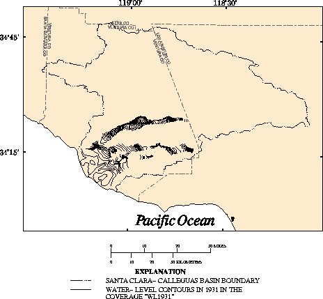
Description:        Selected ground-water levels for autumn 1931 from State of
                    California Department of Public Works.

Data type:          LINE.

Source:             Modified from:
                    California Department of Public Works, 1933, Ventura County
                    investigation: California Department of Public Works,
                    Division of Water Resources Bulletin No. 46, 244 p., pl.
                    XLIX.

Source scale:       1:108,600 (approximate)

Source projection:  Unknown.

Method of entry:    Water levels were manually digitized from a paper source
                    map using an Altek Datatab AC40 digitizing tablet, which
                    has a resolution of 0.002 inch. The geographic features and
                    control points (points of known coordinate locations) were
                    digitized and transformed into real-world coordinates.

Quality control:    The coverage was plotted and compared with the source map.

Projection of data: Universal Transverse Mecator projection: Zone 11, Y-shift
                    -3.5 million meters.

Final update:       July 23, 1993

Description
of variables:       WL1931 line attribute table.


Variable     Type     Length  Definition

CONTOUR(FT)  Integer  6       Ground-water-level elevation above sea level, in feet.