Fact Sheet 94-029
U.S. GEOLOGICAL SURVEY
Fact Sheet 94-029
By Joseph Domagalski and Larry R. Brown
In 1991, the U.S. Geological Survey (USGS) began to implement a full-scale National Water-Quality Assessment (NAWQA) program. The long-term goals of the NAWQA program are to describe the status of and trends in the quality of a large, representative part of the Nation's surface- and ground-water resources and to identify the major natural and human factors that affect the quality of those resources. In addressing these goals, the program will provide a wealth of water- quality information that will be useful to policy makers and managers at the national, State, and local levels.
A major asset of the NAWQA program is that it will allow for the integration of water-quality information collected at several scales. A major component of the program is the study-unit investigation-the foundation of national- level assessment. The 60 study units of the NAWQA program are hydrologic systems that include parts of most major river basins and aquifer systems of the conterminous United States. These study units cover areas of 1,000 to more than 60,000 square miles and represent 60 to 70 percent of the Nation's water use and population served by public water supplies. Investigations of the first 20 study units began in 1991. In 1994, the Sacramento River Basin was among the second set of 20 NAWQA study units selected for investigation.
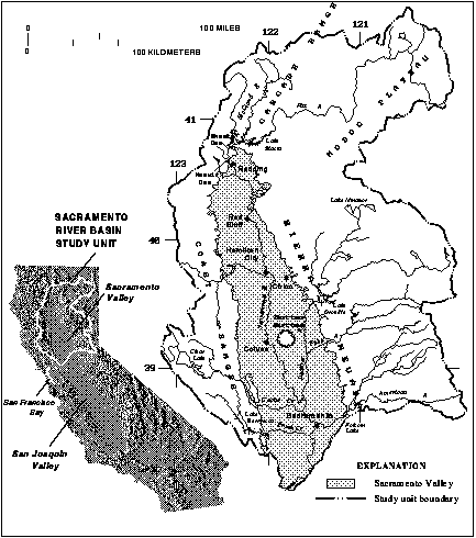
The Sacramento River Basin covers nearly 27,000 square miles. The study unit includes all or parts of five physiographic provinces: the Sacramento Valley, the Sierra Nevada, the Coast Ranges, the Cascade Range, and the Modoc Plateau. The Sacramento River is the largest river in California, with an average annual runoff of 22,000,000 acre-feet. This is approximately one third of the total runoff in the State. The length of the Sacramento River is 327 miles. The river is vital to the State's economy and is a major source of drinking water for residents of northern and southern California. The Sacramento River is a principal source of irrigation water for Sacramento and San Joaquin Valley farmers and freshwater flow to the San Francisco Bay.
Water use in the study unit was 11.6 million acre-feet in 1990, and this amount is expected to rise to 12.4 million acre-feet by the year 2020. Water use in 1990 was 58-percent agricultural, 32-percent environmental, 6-percent urban, and 4-percent other. Up to about 6 million acre-feet per year of water also is exported from the basin, principally to areas in southern California, by local, State, and Federal conveyance facilities. The flows of the Sacramento River are controlled mainly by Shasta Dam and, to a lesser extent, by dams on the Feather, Yuba, and American Rivers. Part of the runoff from winter rains and spring snowmelt is stored in reservoirs and released during the normally dry summer months. Most of the water supplies are derived from these reservoirs.
The Sacramento Valley is a major ground-water basin and can be considered a single-aquifer system. The storage capacity of the Sacramento Valley ground-water basin is about 114 million acre-feet at depths of 20 to 600 feet below land surface. Ground water provides about 22 percent of the water supply and is used extensively as a source of drinking and irrigation water, particularly in areas removed from surface-water supplies.
The Sacramento Valley supports a diverse agricultural economy, much of which depends on the availability of irrigation water. More than 2 million acres are irrigated. Major crops include rice, fruits and nuts, tomatoes, sugar beets, corn, alfalfa, and wheat. Dairy products are also an important agricultural commodity. In the study unit, the Sacramento Valley has the largest cities, including Chico, Red Bluff, Redding, and Sacramento. The Sacramento metropolitan area is home to more than 1 million people, which is nearly half of the total population of 2,208,900 people, in the study unit. The population in the study unit increased by more than a one-half million people between 1980 and 1990. Land cover within the Sierra Nevada and Cascades Range is principally forest. Forest and range land are mixed throughout the Coast Ranges and Modoc Plateau.
The Sacramento River Basin contains a number of species, subspecies, and genetically distinct populations of fish that are presently listed as Federal or State threatened/endangered species or species that appear to be approaching that status. The winter-run race of chinook salmon (Oncorhynchus tschawytscha) that spawn below Keswick Dam in the mainstem Sacramento River is on the Federal list of endangered species. The spring-run chinook salmon that spend the summer in deep, cool pools of streams tributary to the Sacramento River before spawning in the early fall are presently a species of special concern, and efforts are being made to increase its population before the species becomes endangered. The Sacramento splittail, Pogonichthys macrolepidotus, a large minnow native to the Sacramento-San Joaquin drainage and the only remaining representative of the genus in the world, has been officially proposed as a threatened species by the U.S. Fish and Wildlife Service.
The NAWQA study will focus on the quality of ground-water and surface-water resources in the Sacramento Valley, because most of the population, agriculture, and water use are in that part of the study unit. Information for the other physiographic provinces will be used primarily to establish background water- quality conditions or to establish loadings of key water-quality constituents. The major water-quality issues of concern in the Sacramento River Basin study unit are:
Communication and coordination between USGS personnel and other interested scientists, water-management organizations, and public and private interest groups are critical components of the NAWQA program. Each of the study units will have a liaison committee consisting of representatives from Federal, State, and local agencies, universities, environmental groups, and the private sector who have water-resources responsibilities. Specific activities of each liaison committee will include the exchange of information about water-quality issues of regional and local interest; the identification of sources of data and information; assistance in the design and scope of project products; and the review of project-planning documents and reports. The liaison committee for the Sacramento River Basin study unit will be formed in 1994.
Joseph Domagalski
Larry R. Brown
Project Chief--Sacramento River Basin NAWQA Study
U.S. Geological Survey
Placer Hall, Bldg. 56
6000 J Street
Sacramento, California 95819-6129
E-mail: mailto:joedusgs.gov
USGS Sacramento River Basin NAWQA
USGS Headquarters
USGS Water Resources of California
USGS National Water Quality Assessment (NAWQA) Program

![]() U.S. Department of the Interior | U.S. Geological Survey
U.S. Department of the Interior | U.S. Geological Survey
URL: https://pubs.usgs.gov/fs/1994/fs94029
Page Contact Information: Publications Team
Page Last Modified:
Tuesday, 29-Nov-2016 18:02:05 EST
